Let’s be honest: road trips across America give you something flights just can’t. You get to roll through jaw-dropping landscapes, stumble on quirky roadside oddities, and find hidden gems you’d never see from 30,000 feet.
Sure, the original plan is to get from point A to point B. But somewhere along the way, the journey takes over, and suddenly every mile is a story waiting to happen.
The best American road trips are the ones where the drive itself steals the show. Sometimes you’re hugging dramatic cliffs, sometimes you’re winding through forests older than your great-grandparents. You’ll want to slow down, not race ahead.
I’ve pulled together ten routes that capture that magic. Think legendary highways, scenic byways, rugged coasts, and national parks that practically demand a photo stop every five minutes.
Ready? Let’s hit the road.
Pacific Coast Highway: California’s Iconic Coastal Drive
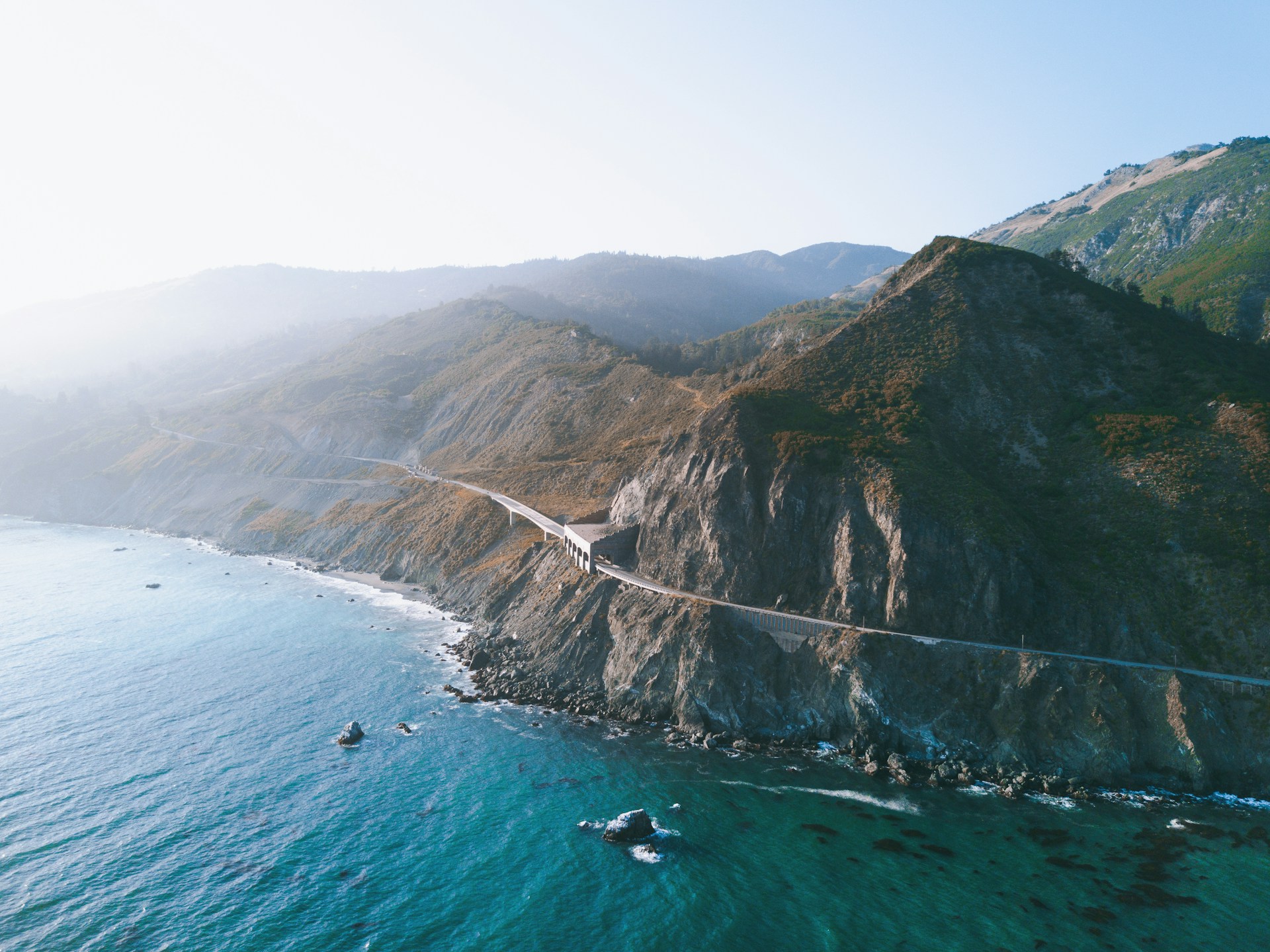
The Pacific Coast Highway (Highway 1) runs for 655 miles, from Dana Point up to Leggett. It’s packed with breathtaking coastal views.
Big Sur sometimes throws a wrench in your plans with landslides, but with a little planning and a few detours, you can still make this legendary drive happen.
Must-See Stops Along Highway 1
Start your adventure in Los Angeles and Santa Monica. I always try to leave before sunrise to skip the infamous LA traffic.
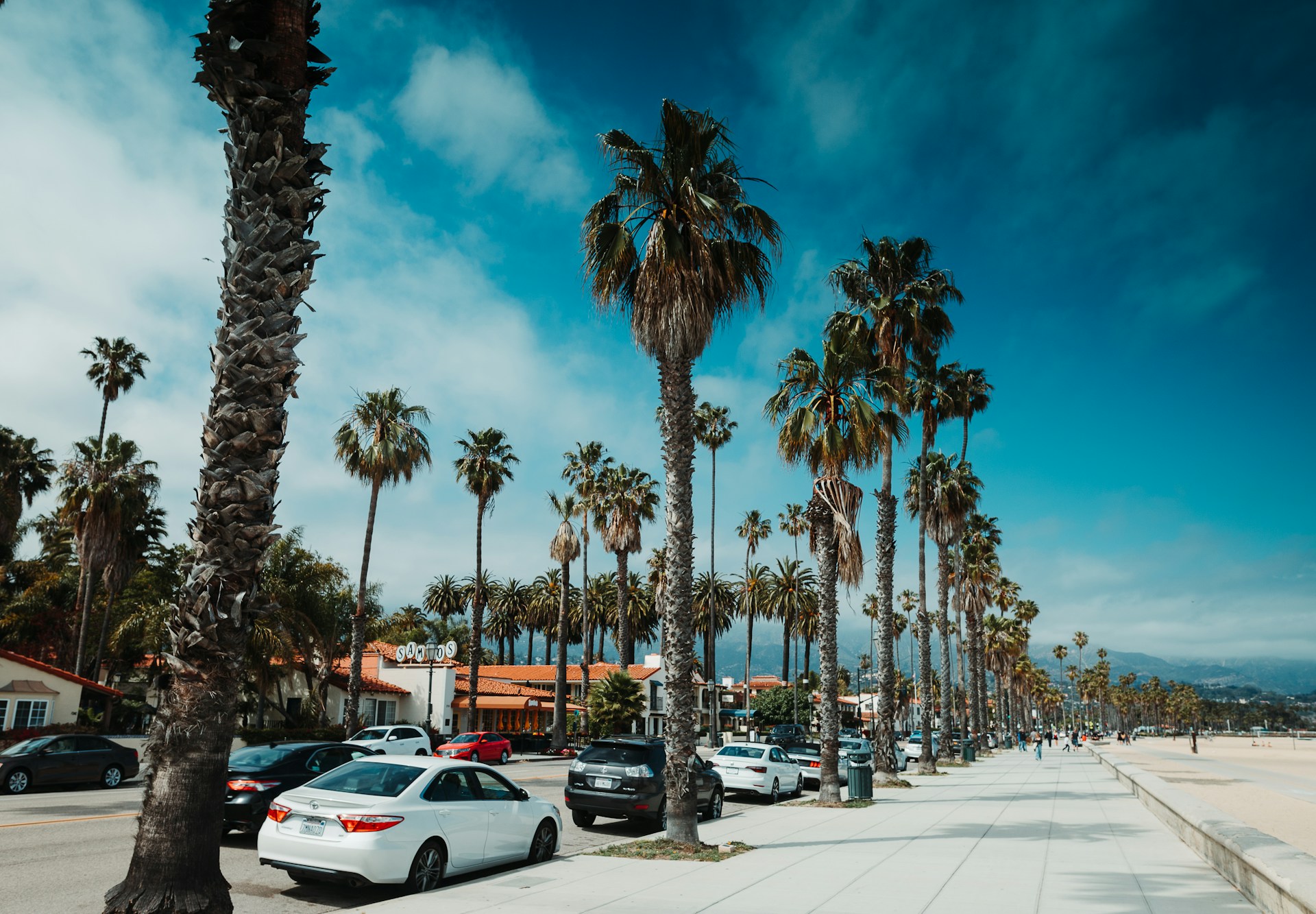
Santa Barbara charms with its Spanish colonial vibes and beaches that make you want to stay all day. Downtown is walkable, full of tempting restaurants and little shops.
Big Sur is the crown jewel of the route. Even with road closures, you can’t skip it. McWay Falls drops dramatically onto the sand, and the Bixby Creek Bridge is so photogenic it’s almost cliché.
Monterey brings you the famous aquarium and Fisherman’s Wharf. Nearby, Carmel-by-the-Sea feels like stepping into a storybook, with its quirky cottages and perfect beaches.
San Francisco wraps things up with the Golden Gate Bridge and those crazy-steep streets. Don’t miss Lombard Street or the sea lions at Fisherman’s Wharf.
Other must-stops:
- Hearst Castle in San Simeon
- Morro Bay and its iconic rock
- Half Moon Bay if you’re into pumpkin patches or just want more coastal charm
Driving Tips for the Perfect Coastal Adventure
Plan ahead. Check for Big Sur closures—landslides happen more often than you’d think. Highway 101 is your main detour.
Don’t risk running out of gas. Fill up whenever you can, especially before the more remote stretches. Gas gets pricier the further you go.
Drive south to north for better ocean views. It’s a small thing, but trust me, it’s worth it.
Pack layers. I’ve gone from sweating in shorts to shivering in a hoodie on the same day.
Download your maps. Cell service drops out in the wild stretches, so don’t count on Google Maps.
Take it slow on those curves. Some sections are twisty with steep drop-offs. Use the pullouts for photos—there’s no rush.
Bring a portable charger. You’ll take more photos than you expect, and dead batteries are the enemy of epic road trips.

Best Time to Experience Big Sur and the Central Coast
February through April is my favorite window. The rains end, the hills turn green, and wildflowers pop up everywhere.
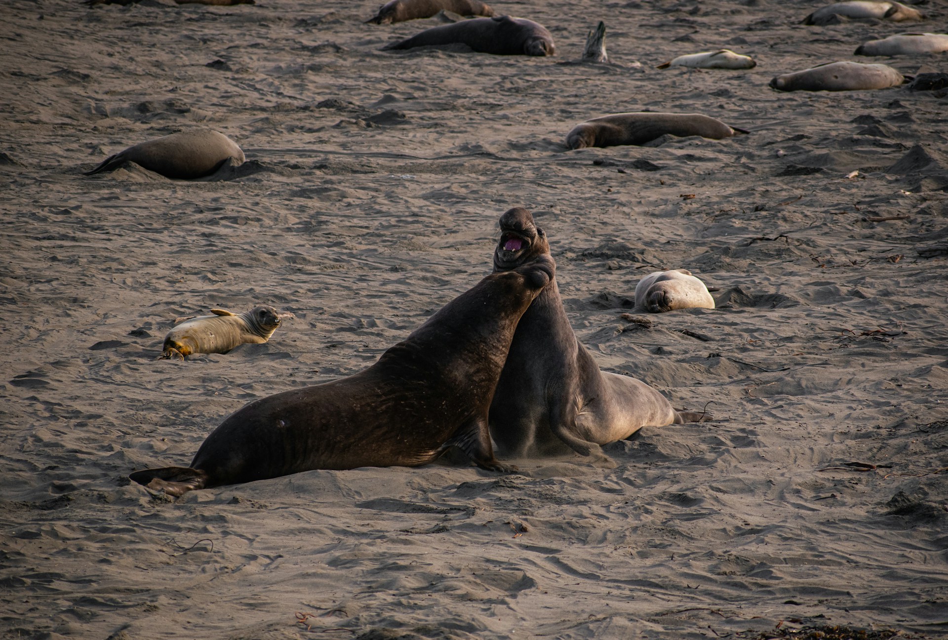
It’s also elephant seal pupping season at Piedras Blancas near San Simeon. Watching those massive creatures is wild.
Whale watching is best from February to May. Gray whales and humpbacks cruise close to shore.
Summer brings golden hills and blue skies, but also more crowds and higher hotel prices.
Fall can be risky with wildfires. Always check for restrictions if you’re camping.
Winter means rain, fog, and the occasional landslide. Road conditions can change fast.
If you want waterfalls and wildflowers, spring is unbeatable.
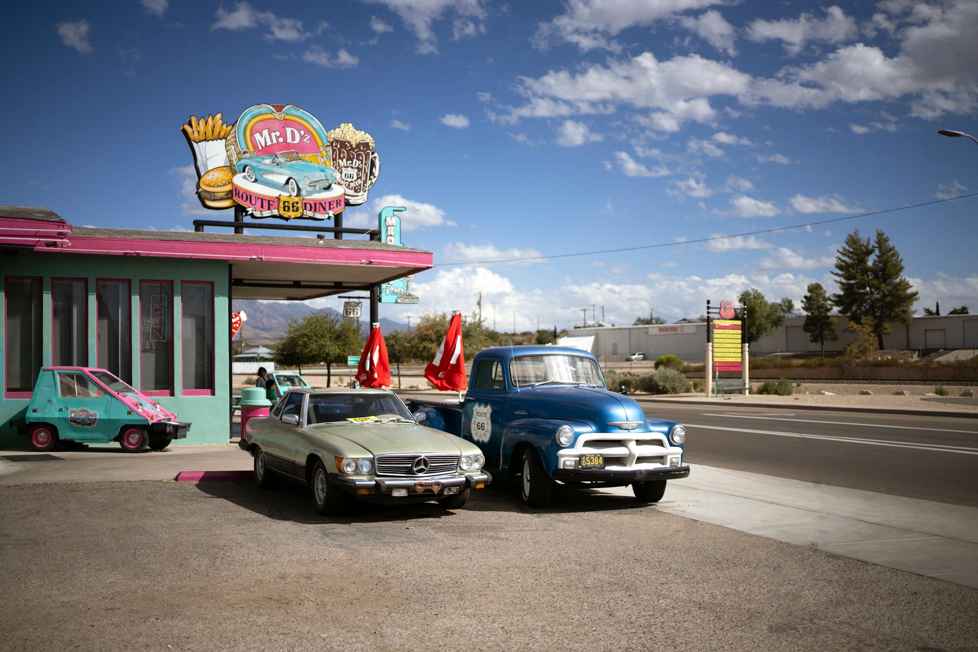
Route 66: Following the Mother Road Across America
Route 66 stretches a whopping 2,448 miles from Chicago all the way to Santa Monica. It’s pure Americana—think classic diners, neon motels, and roadside oddities that make you pull over just to see what’s going on.
Chicago to Santa Monica: Starting and Ending Points
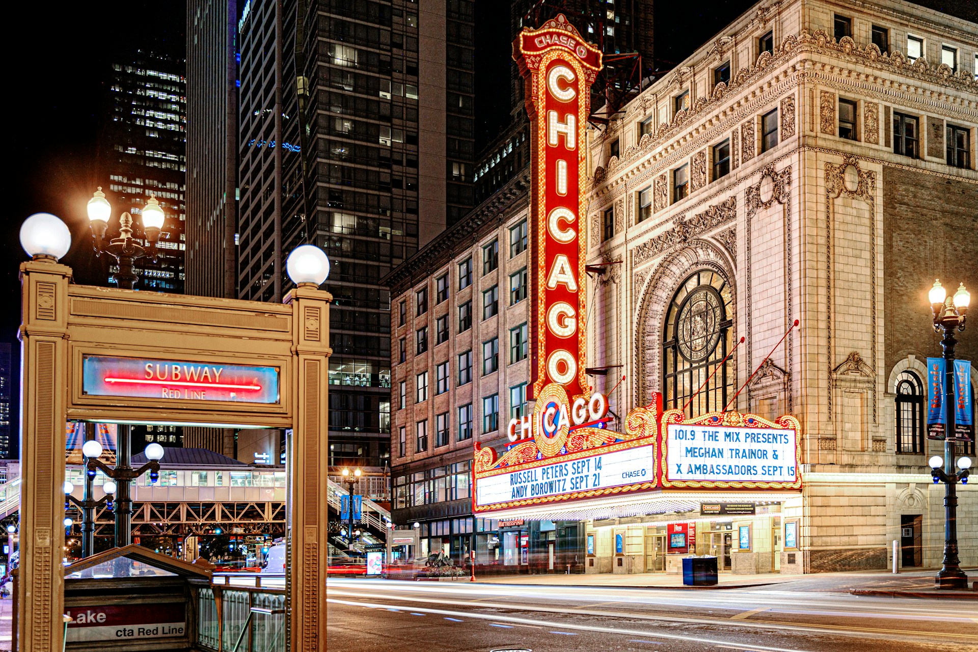
Kick things off at Grant Park in Chicago, the official start of Route 66. I always grab some deep-dish pizza at Lou Malnati’s and stock up on snacks at Lou Mitchell’s before heading out.
Chicago’s got plenty to explore before you hit the open road. The Willis Tower and Navy Pier are worth a quick look, and the Art Institute sets the tone for the American culture you’ll see along the way.
You’ll wrap up the journey at Santa Monica Pier in California. The iconic sign marks the end of Route 66 where it meets the Pacific.
Santa Monica Pier’s carousel and Ferris wheel have greeted road trippers for generations. It’s a pretty sweet contrast to the city buzz of Chicago.
If you want to do the whole thing justice, plan for 10-14 days. You’ll want to linger in some of these small towns.
Unmissable Route 66 Landmarks and Attractions
You can’t miss Cadillac Ranch in Amarillo, Texas. Ten old Cadillacs, half-buried in a field, covered in spray paint. Bring your own can and add to the art.
The Wigwam Motel in Holbrook, Arizona lets you sleep in concrete teepees straight out of the 1950s.
St. Louis brings you the Gateway Arch—a 630-foot monument that feels like the gateway to the West. It’s fun to ride the tram to the top if you’re not claustrophobic.
Detour to Arizona’s Petrified Forest National Park for ancient fossilized trees and otherworldly painted deserts.
The Grand Canyon isn’t technically on Route 66, but it’s close enough to justify a side trip. Those canyon views are unreal.

Essential Americana: Motels, Diners, and Culture
Diners on Route 66 serve up comfort food that’s basically a rite of passage. The Cozy Dog Drive Inn in Springfield, Illinois claims to have invented the corn dog—worth a stop.
You’ll spot neon signs everywhere, glowing reminders of the golden age of road travel.
Classic motor lodges line the route, each with its own weird theme. I always try to stay at the Blue Swallow Motel in Tucumcari, New Mexico. The neon is original, and you feel like you’ve stepped back in time.
Drive-in theaters still exist here, like the Route 66 Drive-In in Carthage, Missouri. Watching a movie under the stars is a treat.
Trading posts and gift shops are packed with Route 66 memorabilia. I’ve found everything from vintage postcards to handmade crafts.
Small towns along the way often have little museums dedicated to Route 66 history. It’s worth popping in if you’re curious about the stories behind the signs.
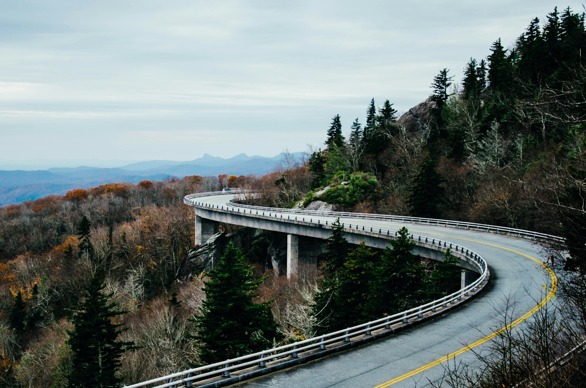
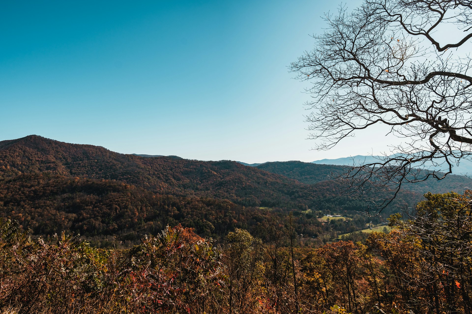
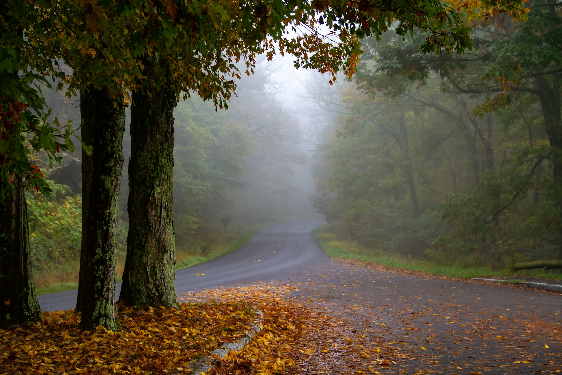
Blue Ridge Parkway: The Appalachian Highlands Journey
The Blue Ridge Parkway runs for 469 miles through Virginia and North Carolina. It links two major national parks and shows off the best of Appalachian scenery.
You’ll pass historic mills, waterfalls, grand estates, and mountain views that change with every turn.
Virginia to North Carolina: Parkway Highlights
Start at Shenandoah National Park in Virginia and head south. The mileposts go from 0 to 469, so it’s easy to keep track.
Key Drive Times:
- Afton to Roanoke (MP 0-120): About 3.5 hours
- Roanoke to Fancy Gap (MP 120-199): 2.5 hours
- Fancy Gap to Blowing Rock (MP 199-293): 3 hours
- Blowing Rock to Asheville (MP 293-382): 3 hours
The speed limit is usually 45 mph. It’s slow, but that’s the point—soak up the scenery.
I recommend at least a weekend to do the whole drive. You could blast through in 10 hours, but honestly, why rush?
The parkway doesn’t charge an entrance fee. You can stop wherever you like, not just at the official overlooks.
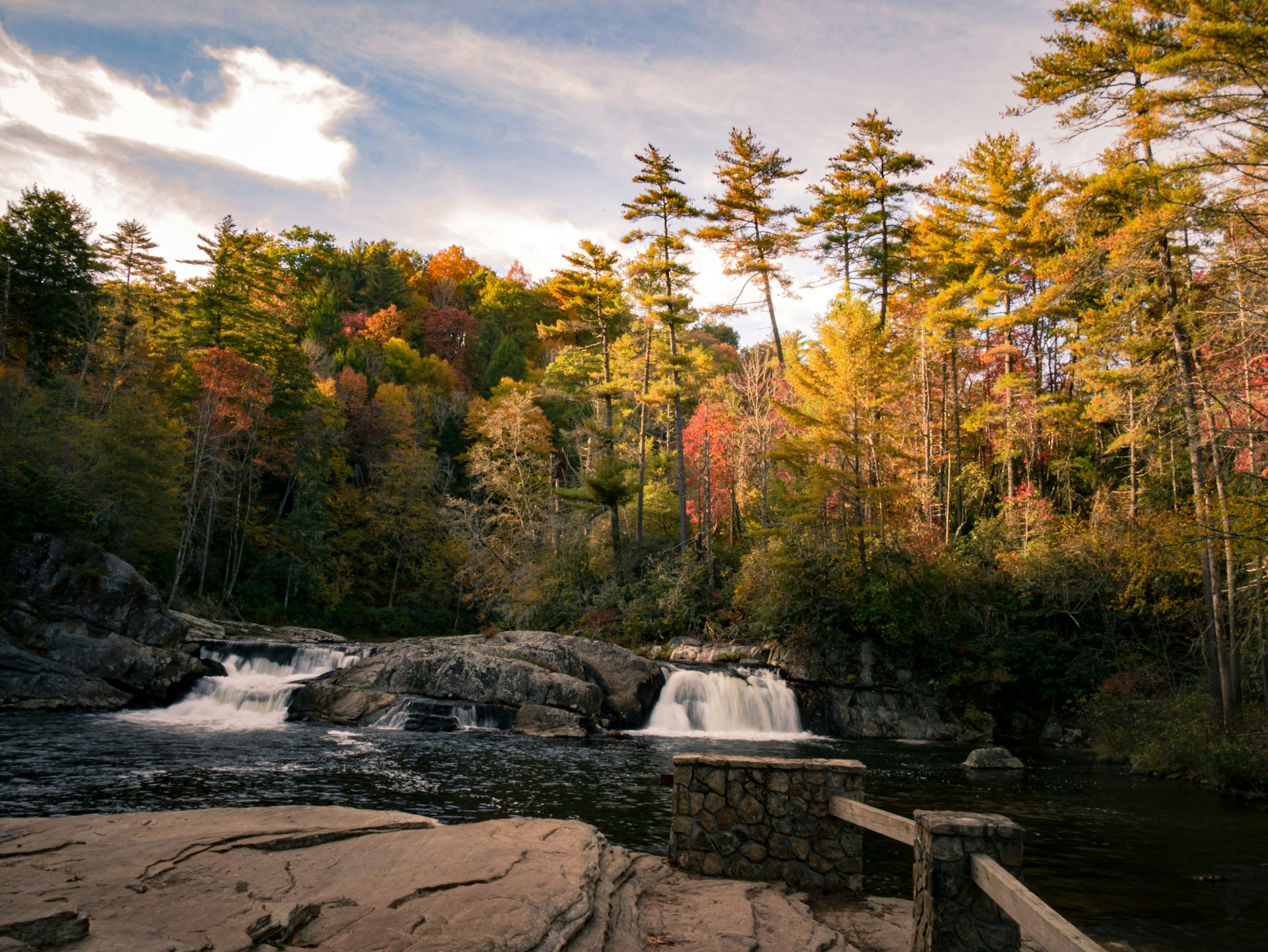
Scenic Spots: Linville Falls and Mabry Mill
Linville Falls in North Carolina is a must. The hike to the falls is short and gives you several great viewpoints. The water drops about 90 feet into Linville Gorge—pretty impressive.
Mabry Mill at milepost 176 in Virginia is one of the parkway’s most photographed spots. This old grist mill from 1910 still runs during certain times of the year.
The pond in front of the mill is perfect for reflection shots. I like to visit in the early morning when the light’s just right.
Both spots have parking and restrooms. Mabry Mill even has a snack bar and gift shop in the busy season.
Exploring Asheville and the Biltmore Estate
Asheville, near milepost 382, is a great base for the southern stretch of the parkway. The city’s got a laid-back vibe, awesome food, and a thriving craft beer scene.
The Biltmore Estate is America’s largest private home. George Washington Vanderbilt II built it in the 1890s, and it’s still jaw-dropping. Buy your tickets ahead of time—especially during busy months.
There are formal gardens, a winery, and miles of trails. Give yourself a full day to explore.
Asheville also gives you easy access to both the Blue Ridge Parkway and Great Smoky Mountains National Park. Hotels and restaurants here know how to cater to road trippers.
Connecting to Shenandoah and Great Smoky Mountains
The Blue Ridge Parkway connects two epic national parks. Shenandoah National Park is the northern launch point at milepost 0.
At the southern end, you’ll roll right into Great Smoky Mountains National Park near Cherokee, North Carolina. It’s a rare chance to hit three protected areas in one trip.
Oconaluftee is the main entrance to the Smokies from the parkway, with a cool farm museum and visitor center.
Grab park passes for both parks if you want to explore beyond the parkway. Each one has extra trails, waterfalls, and wildlife that make your Appalachian road trip even better.
The Great American National Parks Circuit
This route links America’s most stunning national parks with highways that are as memorable as the parks themselves. From Montana’s wild peaks to Utah’s red rocks, every drive brings something new—wildlife, geology, and plenty of “wow” moments.
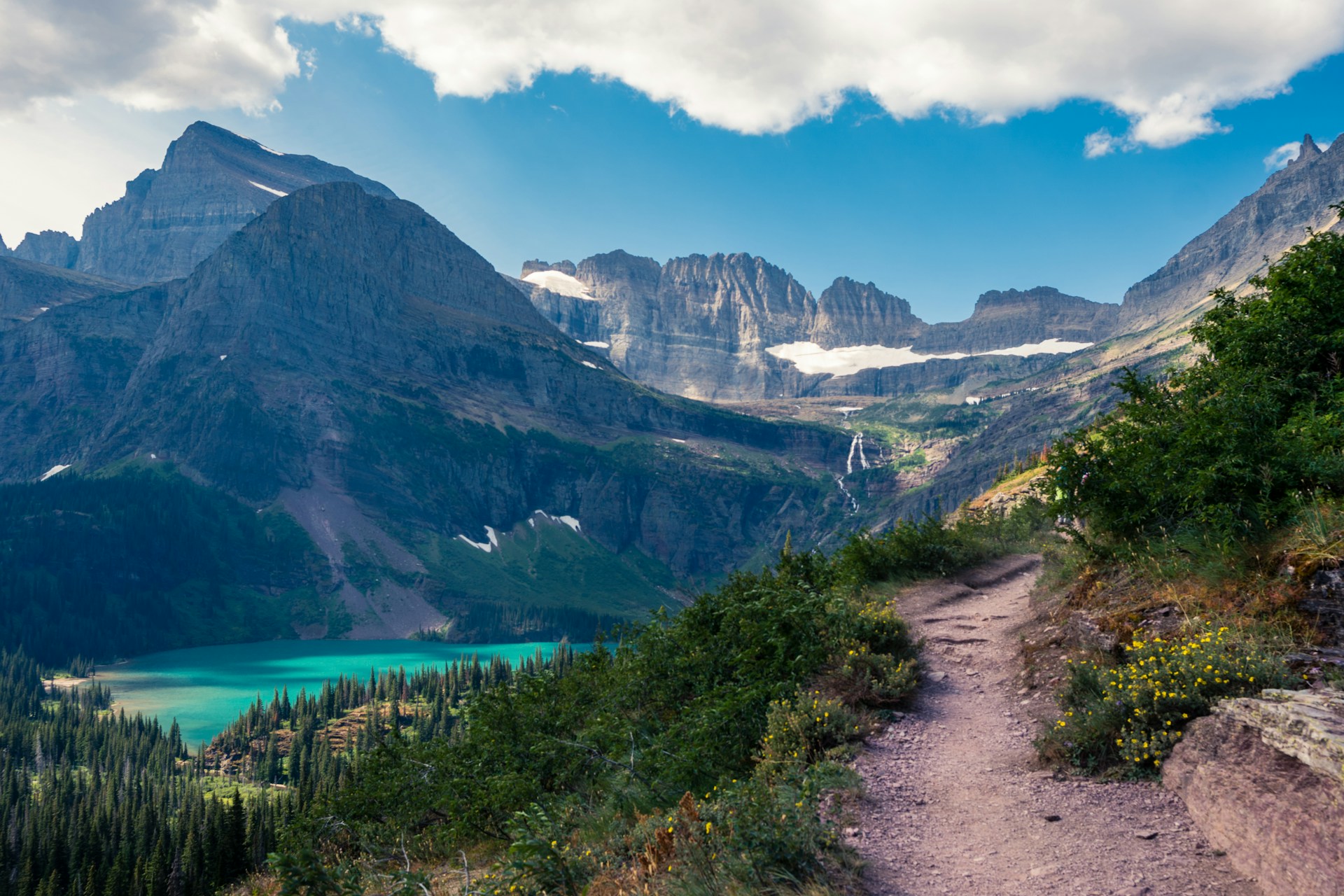
Going-to-the-Sun Road in Glacier National Park
Going-to-the-Sun Road is justifiably famous. This 50-mile stretch cuts right through Glacier National Park in Montana.
The road climbs over 3,000 feet up to Logan Pass, topping out at 6,646 feet. I’ve driven it a few times, and honestly, it never gets old.
Don’t miss:
- Hidden Lake Overlook – An easy 1.5-mile hike from Logan Pass with killer views
- Bird Woman Falls – 492 feet of waterfall you can see from the road
- Weeping Wall – Water pours right onto the road (your car might get a little shower)
The road is narrow and has strict vehicle limits. If your RV is over 21 feet long or 8 feet wide, you’ll have to find another way. Most of the time, snow closes the road in winter.
Keep an eye out for mountain goats and bighorn sheep near Logan Pass. I always start early to avoid the crowds and those pesky afternoon storms.
Utah’s Mighty Five: Arches, Canyonlands, Zion, Bryce Canyon, Capitol Reef
Utah’s five national parks make up one of the best road trips I’ve ever taken. The red rock landscapes change so much from park to park, it’s almost hard to believe you’re still in the same state.
Arches National Park? Over 2,000 natural stone arches—honestly, it’s like nature just kept showing off. Delicate Arch stands out as Utah’s most iconic landmark. The scenic drive winds past Courthouse Towers and the twisted maze of Fiery Furnace.
Canyonlands National Park sits just a quick drive from Arches. Sunrise at Mesa Arch blew me away; the arch frames the distant mountains perfectly. The Island in the Sky district gives you easy access to some jaw-dropping overlooks.
Zion National Park brings you into a world of towering sandstone cliffs and those famous slot canyons. The main road follows the Virgin River right through Zion Canyon, and every bend feels photo-worthy.
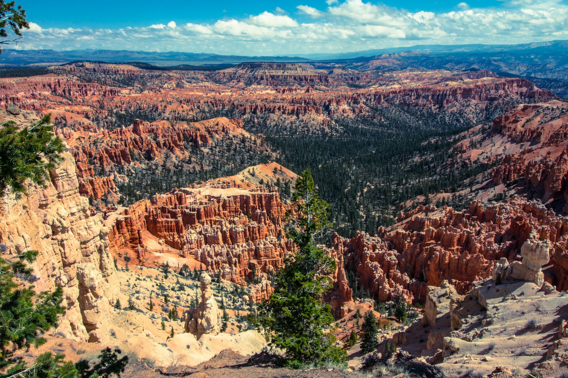
Bryce Canyon National Park is all about hoodoos—thousands of them. Red rock spires crowd together in wild shapes. If you don’t want a tough hike, the rim trail offers insane views with minimal effort.
Capitol Reef National Park protects this massive 100-mile wrinkle in the earth called the Waterpocket Fold. I wandered through historic Fruita, grabbed fresh fruit in season, and soaked up a bit of pioneer history.
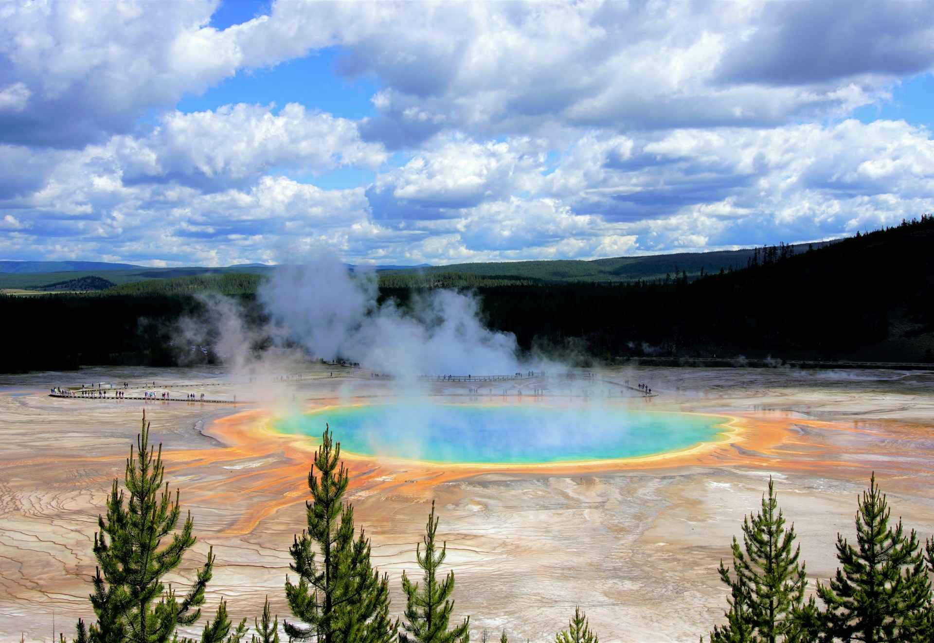
Yellowstone and the Beartooth Highway
Yellowstone National Park in Wyoming connects directly to one of the most breathtaking mountain roads I’ve ever driven. The Beartooth Highway (US-212) links Yellowstone with Montana, and the alpine scenery is just… next level.
The highway climbs to 10,947 feet at Beartooth Pass. It usually opens from late May to mid-October, since snow blocks the way the rest of the year.
Yellowstone’s highlights?
- Old Faithful erupts like clockwork every 90 minutes
- Grand Prismatic Spring glows with wild rainbow colors
- Lamar Valley is the spot for wildlife—think bison, wolves, and elk
Driving the Beartooth Highway, you’ll see glacial lakes, rugged peaks, and sometimes even snow in July. I’ve spotted mountain goats, marmots, and pika along the way—makes the drive feel like a real adventure.
Red Lodge, Montana, marks the northern entrance. You’ll find plenty of places to eat and stay before heading up into the high country.
Wildlife, Scenic Vistas, and Unforgettable Trails
This national parks circuit overflows with wildlife. I’ve watched moose graze in Yellowstone and seen bighorn sheep scale cliffs in Glacier.
My top wildlife viewing spots:
- Lamar Valley, Yellowstone—Wolves, bison, elk at sunrise
- Logan Pass, Glacier—Mountain goats and marmots
- Zion Canyon—Mule deer and wild turkeys
Every park has trails for all skill levels. For easy walks, try Mesa Arch Trail or the Delicate Arch viewpoint. If you’re up for a challenge, Angels Landing in Zion and the Highline Trail in Glacier are epic.
Photographers will have a field day. Golden hour lights up Utah’s red rocks and the peaks in Montana and Wyoming in ways that almost don’t look real.
The drives between parks are just as memorable. I always leave extra time for random photo stops and wildlife sightings—you never know what you’ll see next.

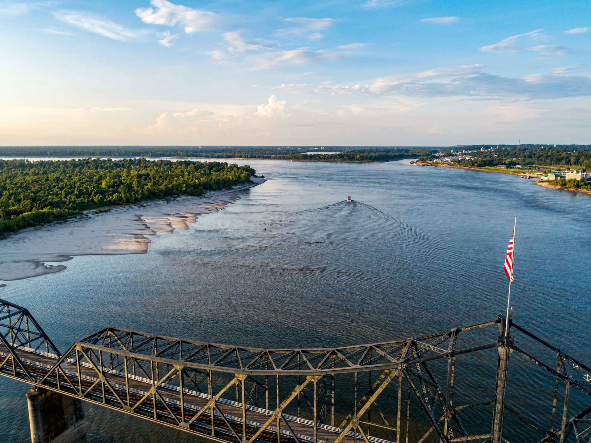
The Great River Road: Tracing the Mississippi’s Legacy
The Great River Road stretches for 3,000 miles along the mighty Mississippi, weaving through 10 states from Minnesota’s Lake Itasca all the way down to Louisiana’s Gulf Coast. If you want to experience real river towns, deep culture, and American history, this is the drive to do.
Minnesota to Louisiana: Route Overview
The Great River Road follows the Mississippi River on a winding journey through America’s heartland. It starts at Lake Itasca in Minnesota, where the river is just a trickle.
The route covers nearly 3,000 miles and passes through Minnesota, Wisconsin, Iowa, Illinois, Missouri, Kentucky, Tennessee, Arkansas, Mississippi, and Louisiana.
Here’s what you need to know:
- Driving time: 36 hours if you never stopped (but why would you do that?)
- Recommended trip length: 4-10 days feels about right
- Route markers: Look for white signs with green pilot’s wheel logos
The road jumps between highways and local roads, sometimes following both sides of the river. Signs are easy to spot, even if you’re not glued to a map.
As you head south, the Mississippi turns from a tiny stream into a powerhouse river, forming state borders and shaping landscapes.
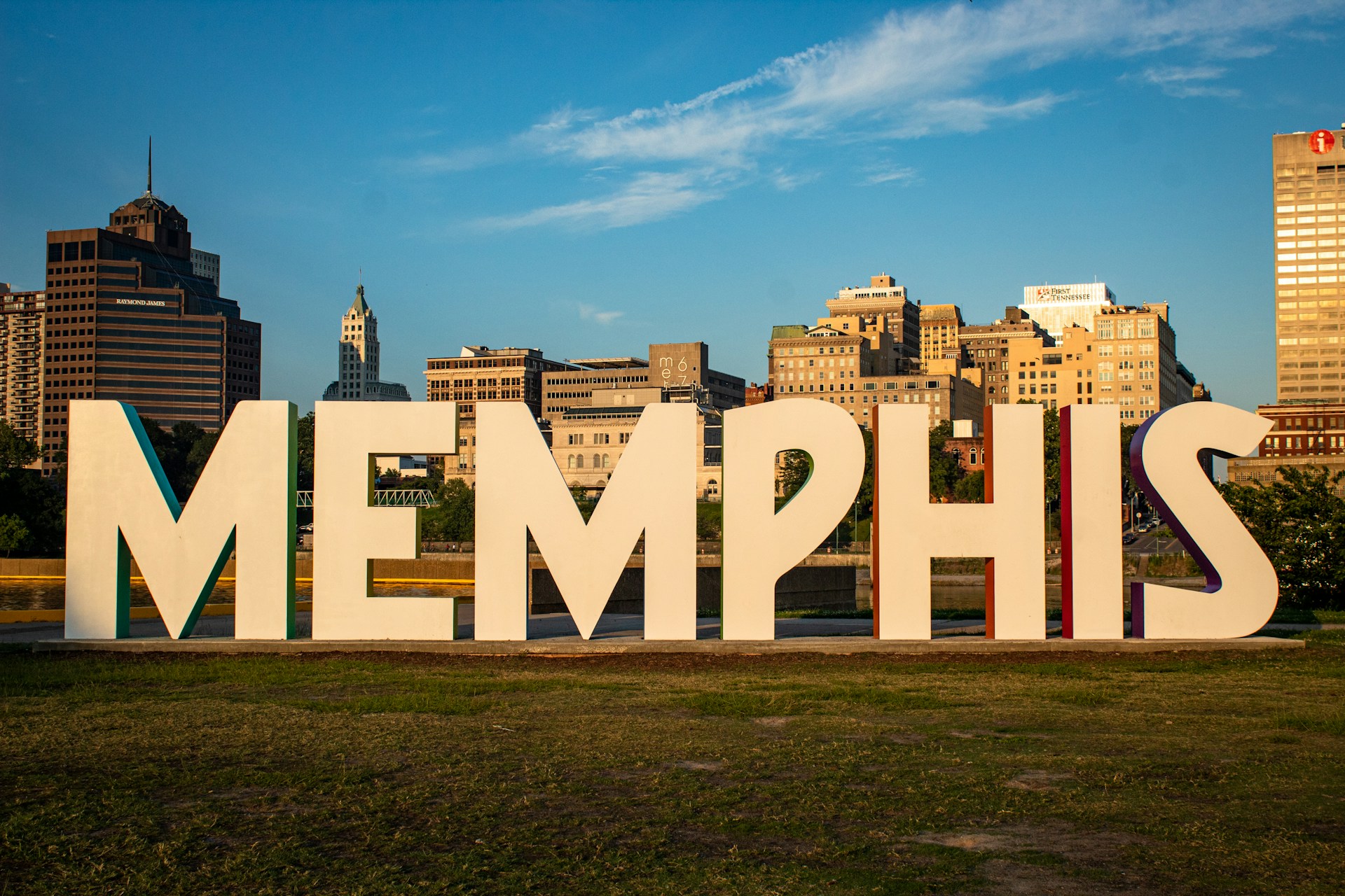
Key Stops—Memphis, Historic River Towns, and Plantations
Memphis is a must-stop. The city sits right on the river and pulses with musical history that shaped America.
Don’t miss in Memphis:
- Beale Street’s live music
- Legendary Sun Studio
- The Mississippi River waterfront
Beyond Memphis, I love exploring the historic river towns sprinkled along the route. Some are tiny, some are bustling, but most have preserved districts and antebellum architecture.
Natchez, Mississippi, and St. Francisville, Louisiana, really wow with their grand plantation homes and lush gardens.
Cool plantation experiences:
- Guided tours of restored mansions
- Wandering historic gardens
- Exhibits on river commerce and life
The Great River Road even connects with Route 66 in southwestern Illinois, so you can tack on another iconic drive if you’re feeling ambitious.
Culture and Cuisine Along the Mississippi
The Mississippi River region gave birth to some of America’s most influential music. Highway 61 through Mississippi? It’s called “Blues Alley” for a reason.
Music lovers, take note:
- The blues started in the Mississippi Delta
- Jazz blossomed in New Orleans
- Country and folk music echo all along the route
Food changes as you go south, and it’s honestly one of my favorite parts. Up north, expect Midwest comfort food—think fish fries and cheese curds. Head south, and you’ll hit barbecue country, then on to Creole and Cajun flavors.
Regional food must-tries:
- Minnesota/Wisconsin: Fish fries, cheese curds
- Memphis: Barbecue ribs, dry rubs
- Louisiana: Gumbo, jambalaya, beignets
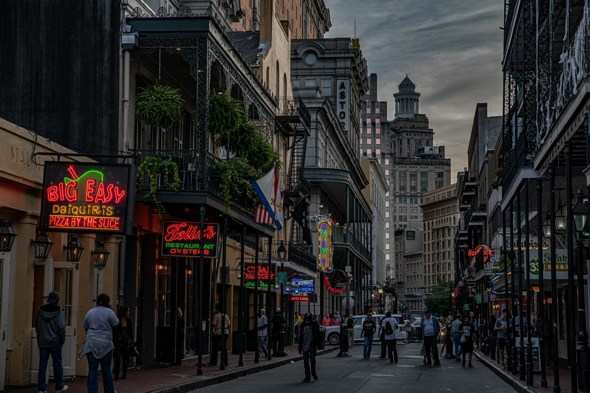
New Orleans caps off the journey with its wild mix of French, Spanish, African, and American influences. The city’s energy is contagious.
If you time your trip right, you’ll stumble into local festivals celebrating everything from music to food to river lore. There’s always something happening.
Coastal Escapes and Dramatic Island Drives
These three routes deliver the thrill of island hopping and endless ocean views. Each drive throws something different at you—sometimes it’s a narrow mountain road, sometimes a bridge that feels like it stretches to the horizon.
Overseas Highway to Key West and the Florida Keys
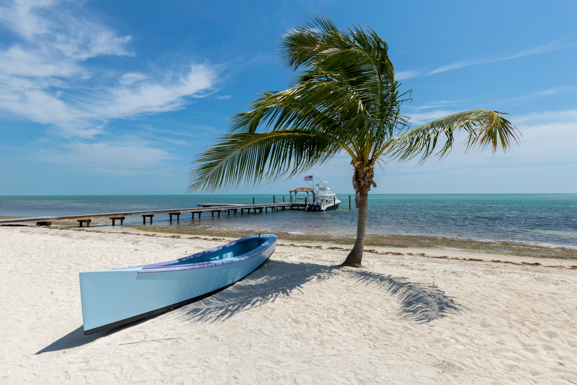
The Overseas Highway runs 113 miles from mainland Florida all the way to Key West. You’ll cross 42 bridges, and the water is almost always that perfect turquoise.
Islamorada makes a great stop for fishing or diving—it’s right between Key Largo and Marathon, so you can’t miss it.
Don’t skip these:
- John Pennekamp Coral Reef State Park—First underwater park in the US
- Islamorada—Sport fishing capital
- Bahia Honda State Park—Arguably the best beach in the Keys
- Key West—Southernmost point in the continental US
The Seven Mile Bridge is the highlight. You’re literally driving above the ocean, with nothing but water on both sides.
I’d plan at least two days for this trip. Key West alone deserves a full day for Duval Street and the quirky historic sites.
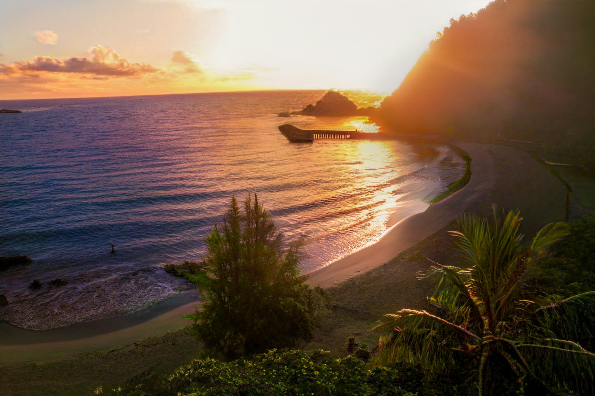
The Hana Highway Adventure in Hawaii
The Road to Hana twists for 64 miles along Maui’s wild northeastern coast. You’ll tackle 620 curves and 59 bridges—yeah, it’s that kind of drive.
Essential stops:
- Twin Falls (mile marker 2)
- Waianapanapa State Park (black sand beach)
- Hana Bay Beach Park
- Oheo Gulch (Seven Sacred Pools)
The Hana Highway isn’t for the faint of heart. Roads get narrow, and you’ll hit plenty of one-lane bridges.
Start early—it takes 3-4 hours without stops, but you’ll want a whole day to enjoy the waterfalls and beaches.
Don’t forget snacks and water. After Paia, gas stations get scarce, so plan ahead.
Outer Banks Scenic Byway Experience
The Outer Banks Scenic Byway stretches for 138 miles along North Carolina’s wild, wind-swept barrier islands. It links Corolla all the way down to Ocracoke Island, and honestly, the drive itself feels like a little adventure.
Must-see attractions:
Wright Brothers National Memorial – This is where the Wright brothers actually launched their first flight. Standing there, you can almost hear the hum of that early engine and imagine the thrill of human flight taking off.
Cape Hatteras Lighthouse – You can’t miss this one. It’s the tallest brick lighthouse in North America, and climbing to the top? Well, it’s a workout, but the view is absolutely worth it.
Jockey’s Ridge State Park – Think of the largest sand dunes on the East Coast. It’s a bit surreal walking up those dunes, especially at sunset when the colors just explode across the sky.
Wild horses just wander around in Corolla. Seriously, you might spot them grazing by the dunes or trotting along the beach. I recommend joining a guided tour if you want the best chance to see them and maybe learn a few local stories.
The byway throws in a twist with ferry rides between Hatteras and Ocracoke islands. Ferries show up every 30 minutes or so during the busy season, and there’s something about rolling your car onto a boat that makes you feel like a real traveler.
If you’re planning this trip, give yourself at least three days. Each island has its own vibe—surfing in Nags Head, poking around the quirky shops and old streets of Ocracoke village, or just letting the sea air clear your head.