Highway 395 snakes through some of California’s wildest landscapes. After a few trips up and down this stretch, I’ve realized some stops just have that extra magic.
This 200-mile ribbon through the Eastern Sierra packs in dramatic rock spires, sparkling alpine lakes, and surreal places that honestly left me gaping out the window. The Alabama Hills, where movie crews have swarmed for decades, and the strange, otherworldly Mono Lake—each spot has its own story, shaped by time and wild forces.
Driving this scenic byway, I stumbled on hidden corners most folks zip right past. The famous stops? They really do live up to the hype.
The Eastern Sierra flips from high desert to jagged peaks in a blink, so the scenery keeps you guessing as you cruise north from Lone Pine toward Nevada.
These seven places, in my opinion, show off the absolute best of Highway 395—whether you’re chasing adventure, snapping photos, or just soaking up some of California’s most jaw-dropping nature. Each one sits right off the main drag, so you can hop out, explore, and get back on the road without a ton of hassle.
The Route: Exploring the Heart of Highway 395
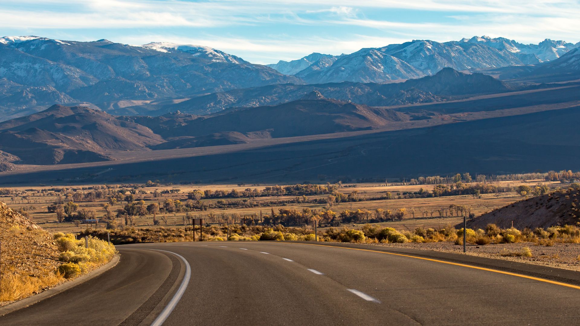
Highway 395 slices through some of California’s boldest terrain. It links desert valleys to snowy peaks along the Sierra’s eastern edge.
The main stretch runs from Lone Pine up through Bishop and beyond. You’ll pass wild natural zones and quirky old towns.
Overview of the Highway 395 Journey
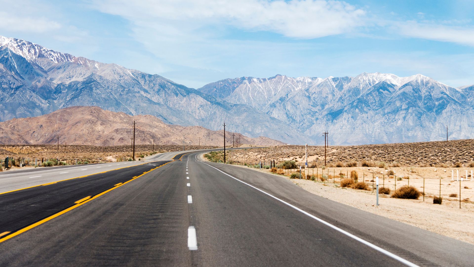
Highway 395 heads north-south, hugging the Sierra Nevada’s eastern base. The most stunning chunk? About 200 miles, from the Mojave Desert up toward Lake Tahoe.
I’ve driven it more times than I can count, and honestly, the variety never gets old. You’ll drop from high desert at 3,000 feet to mountain passes soaring above 8,000 feet.
In just a few hours, you’ll pass through several climate zones. Desert scrub, then pine forests, then wide-open alpine meadows. The Sierra’s snowy peaks always loom to your left.
Key Features:
- Scenic section: roughly 200 miles
- Elevation: 3,000–8,000+ feet
- Drive time: 4–5 hours if you don’t stop (but you’ll want to)
- Best seasons: Late spring through fall
Key Towns and Starting Points
Lone Pine marks the southern door to the Eastern Sierra. This little town sits at 3,727 feet, right beneath Mount Whitney—the highest point in the lower 48.
If you’re coming from L.A., I’d start here. Decent hotels and restaurants, plus it’s your last big supply stop before heading north.
Bishop sits at 4,150 feet and is the biggest town around. It’s a solid base if you want more food and shopping options, and it’s right in the heart of Mono County.
Big Pine is wedged between Lone Pine and Bishop at 3,989 feet. It’s smaller, but it’s the gateway to the Ancient Bristlecone Pine Forest and the Palisade Glacier.
| Town | Elevation | Population | Key Features |
|---|---|---|---|
| Lone Pine | 3,727 ft | ~2,000 | Mount Whitney, Alabama Hills |
| Big Pine | 3,989 ft | ~1,700 | Bristlecone pines, Palisade Glacier |
| Bishop | 4,150 ft | ~3,800 | Largest town, all services |
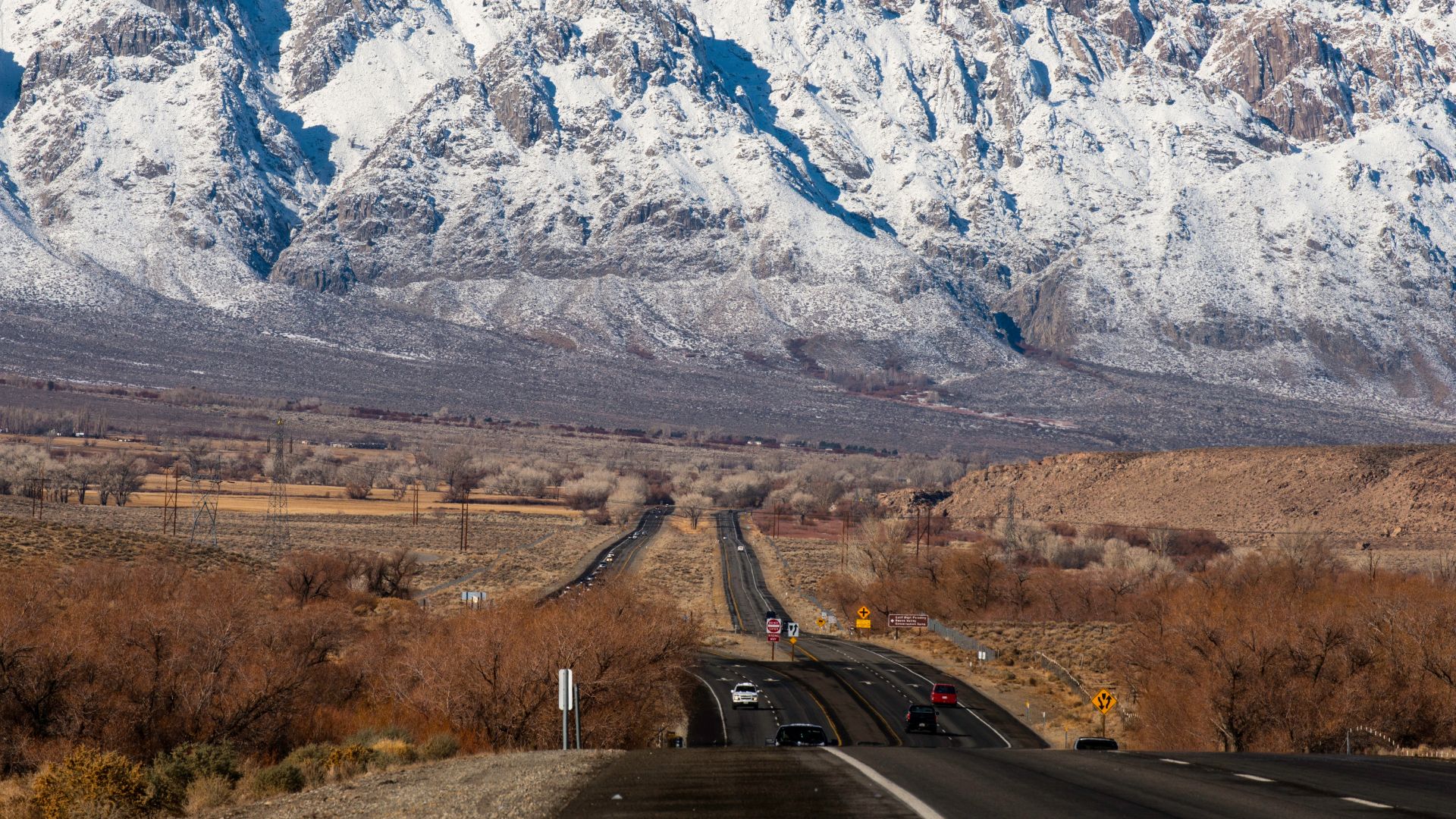
Navigating the Eastern Sierra Section
The Eastern Sierra stretch of 395 takes a little planning. I’ve learned the hard way that a bit of prep can turn an okay trip into an epic one.
Cell service drops out between towns, so I always download my maps and directions ahead of time. I keep my gas tank at least half full, especially if it’s winter.
Weather here is all over the place. You’ll roast in the desert at 100°F, then hit snow at higher passes. I just bring layers, no matter the season.
The highway usually stays open all year, but winter storms can shut things down for a bit. The side roads to the high country? They often close from November through May.
Essential Tips:
- Download offline maps before you go
- Keep your gas tank at least half full
- Double-check road conditions in winter
- Bring extra water and snacks
- Dress in layers (trust me)
Most of the best spots are within 30 minutes of the main road. The Sierra Nevada looms to the west, with peaks shooting up over 14,000 feet. That view alone makes the drive worth it.
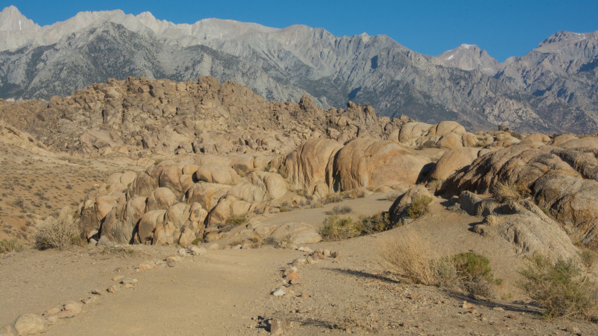
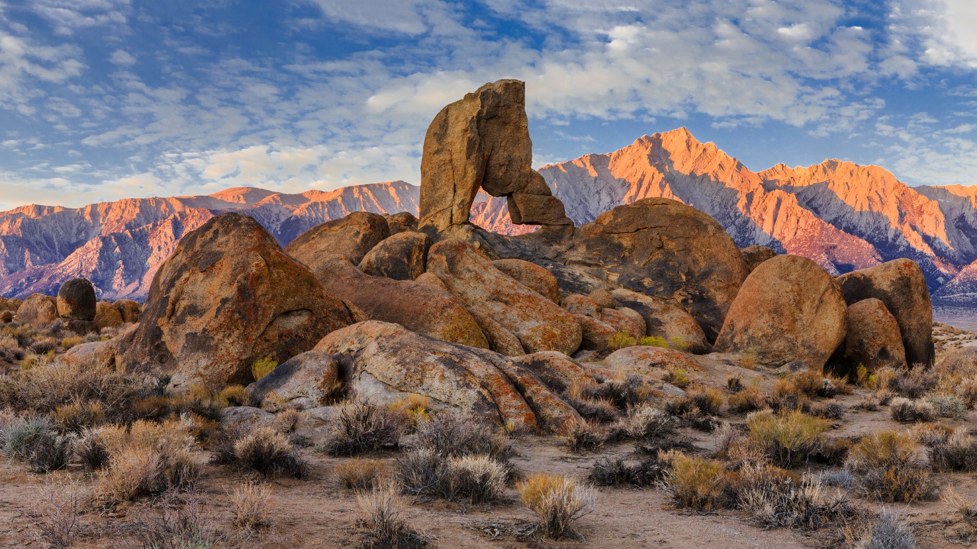
The Alabama Hills: Striking Formations and Cinematic Views
The Alabama Hills are a jumble of round granite boulders, perfectly framing Mount Whitney’s jagged outline. Just outside Lone Pine, this spot has starred in over 400 movies. You’ll find natural arches and winding dirt roads that beg to be explored.
Mobius Arch and Movie Road
Mobius Arch Trail stands out as one of the most satisfying quick hikes I’ve done here. It’s just a 15-minute round trip, and the arch frames Mount Whitney like nature’s own window.
Trailhead Directions:
- Take Highway 395 to Lone Pine
- Head west on Whitney Portal Road for 2.5 miles
- Turn right on Movie Road
- Go 1.5 miles to the Y intersection
- Hang a right and park in the dirt lot on your left
Driving Movie Road is half the fun. You’ll wind through giant boulders, and the Sierra Nevada towers behind you.
Bring your camera. The contrast between the soft, rounded rocks and the razor-sharp peaks is unreal—especially as the light changes.
Mount Whitney and Whitney Portal Road
Mount Whitney completely owns the skyline above the Alabama Hills. At 14,505 feet, it’s the tallest in the lower 48 and makes the granite boulders look tiny.
Whitney Portal Road is the main way into this area. As you drive closer, the view of Whitney keeps shifting and just gets better.
Movie Road has the best spots to see Whitney’s full eastern face. Early morning and late afternoon? That’s when the light really makes the granite glow.
The jump from 4,000 feet in the Alabama Hills to Whitney’s summit is wild. It’s one of the biggest vertical rises you’ll see anywhere in North America. Sunrise and sunset here? Absolutely worth waking up early for.
Hollywood History and Outdoor Activities
Directors have used the Alabama Hills as a backdrop since the 1920s. Old westerns with Tom Mix and Gene Autry? All filmed here.
Famous Films Shot Here:
- Gunga Din
- How the West was Won
- Maverick (1994)
- Django Unchained
- Star Trek Generations
You’ll find photo plaques at over 120 original film sites. Each marker shows a scene from a classic movie filmed right there.
Every October, Lone Pine hosts the Film Festival. There are guest speakers, actors from the old films, and even bus tours to the filming locations.
Besides the movie lore, the Alabama Hills are a playground for rock climbers, hikers, and campers. The granite offers routes for all skill levels. And if you just want to explore, the dirt roads make it easy to get lost in the best way.
Alpine Lakes and Scenic Basins: The Gems of the High Sierra
The Eastern Sierra hides some of California’s most stunning alpine lakes. Crystal-clear water, sharp mountain reflections—it’s the kind of scenery that makes you stop and just stare. Convict Lake, with its dramatic granite backdrop, and the untouched wildness of Little Lakes Valley both stole my heart.
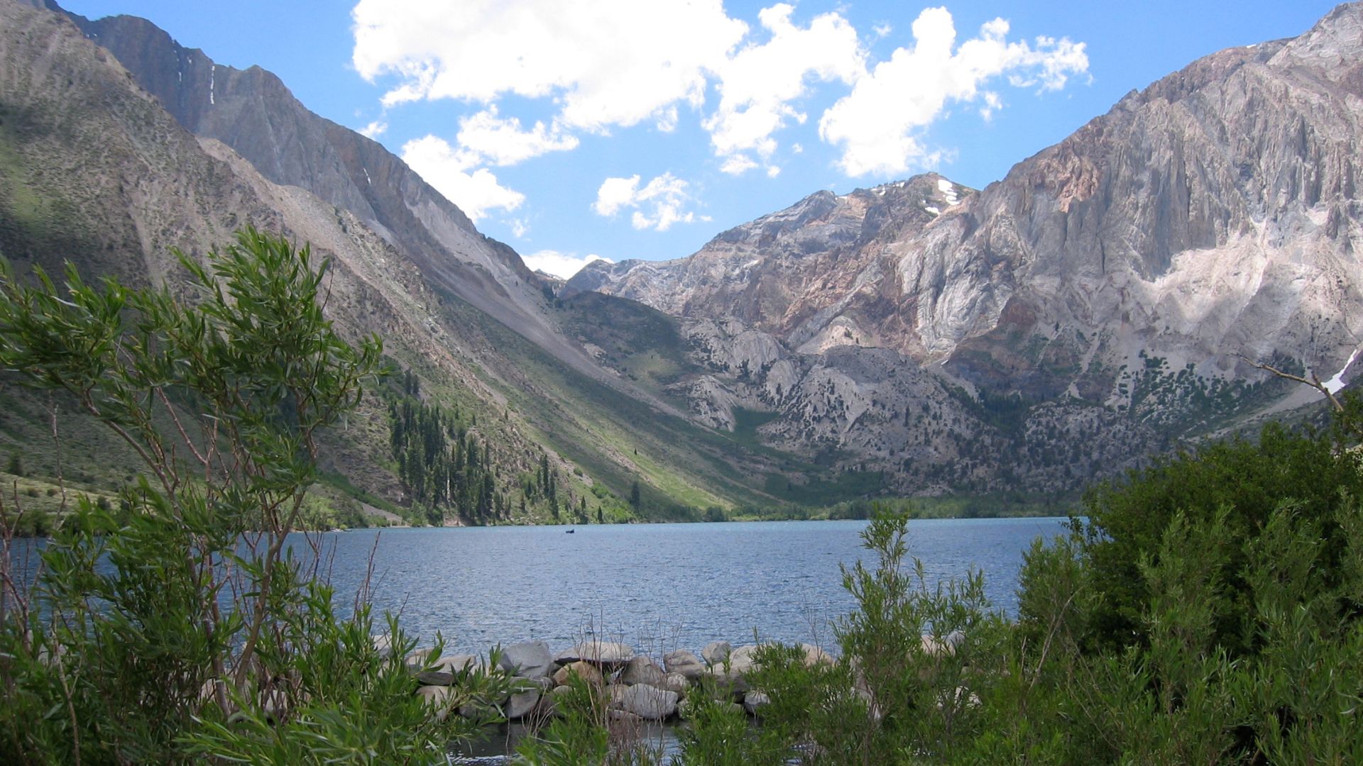
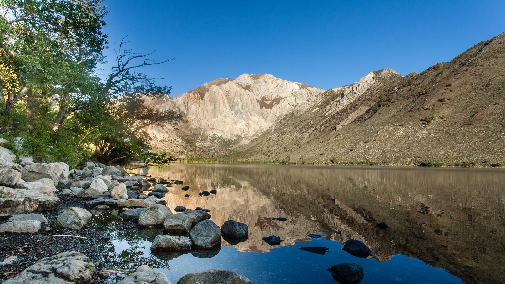
Convict Lake’s Dramatic Beauty
Convict Lake sits like a blue-green jewel, ringed by sheer granite walls, just four miles off Highway 395. I’ve seen a lot of lakes up here, but this one? The setting is next-level.
It got its name from an 1871 shootout between convicts and a posse. These days, people know it for top-notch fishing and easy hiking.
Why Convict Lake is special:
- 2.8-mile loop trail—easy and scenic
- Mirror-like reflections of the cliffs
- Paved road, open year-round
- Resort with boats and a restaurant
The water stays icy even in summer, but the views are worth a little chill. If you can, get there early—the morning light is magic on those granite walls.
Mammoth Lakes Basin and Crystal Lake
The Mammoth Lakes Basin squeezes a dozen alpine lakes into a compact area at 8,900 feet. Crystal Lake is my go-to for a short hike and epic photos.
Crystal Crag looms above, making for one of the most iconic Sierra shots. The hike is just 1.5 miles from the basin, so it’s doable for most folks.
Basin highlights:
- Lake Mary: biggest, with boat rentals
- Lake Mamie: great for a swim
- Horseshoe Lake: spooky dead tree forest
- Crystal Lake: unbeatable mountain backdrop
The Lakes Basin Path links everything, so you can wander from lake to lake without worrying about your car. I’ve spent whole weekends here, just exploring on foot.
June Lake Loop and Silver Lake
The June Lake Loop is a 16-mile scenic detour past four alpine lakes. Silver Lake, sitting highest, has the most dramatic mountain scenery.
June Lake itself has a laid-back resort town vibe. In summer, it’s all about fishing and water sports.
Loop highlights:
- June Lake: main town, restaurants, lodging
- Silver Lake: highest, with hiking trails
- Grant Lake: biggest, best for boating
- Gull Lake: smallest, super peaceful
Carson Peak towers over Silver Lake. The Rush Creek Trail starts here and heads deep into the Ansel Adams Wilderness.
Whenever I’m on the loop, I always stop at Silver Lake. The short walk to the inlet streams gives you mountain reflections that honestly rival Yosemite’s.

Little Lakes Valley and Heart Lake
Little Lakes Valley packs more alpine lakes into a small space than anywhere else I’ve seen in California. I’ve counted over 20 named lakes in this glacial basin.
You’ll start at 10,300 feet near Mosquito Flat. Heart Lake, true to its name, is shaped like a heart and makes for one-of-a-kind photos.
Valley features:
- Elevation: 10,300 to 12,000 feet
- 20+ alpine lakes within easy reach
- 360° mountain views
- Access to several 13,000-foot peaks
The hike to Heart Lake is just 2 miles and gains only 500 feet. Most of these lakes stay frozen until July, so the hiking season is short but incredible.
I’ve never found another spot in California with this kind of alpine lake density. It’s like stumbling into a secret lake district.
Otherworldly Landscapes: Mono Lake and Surroundings
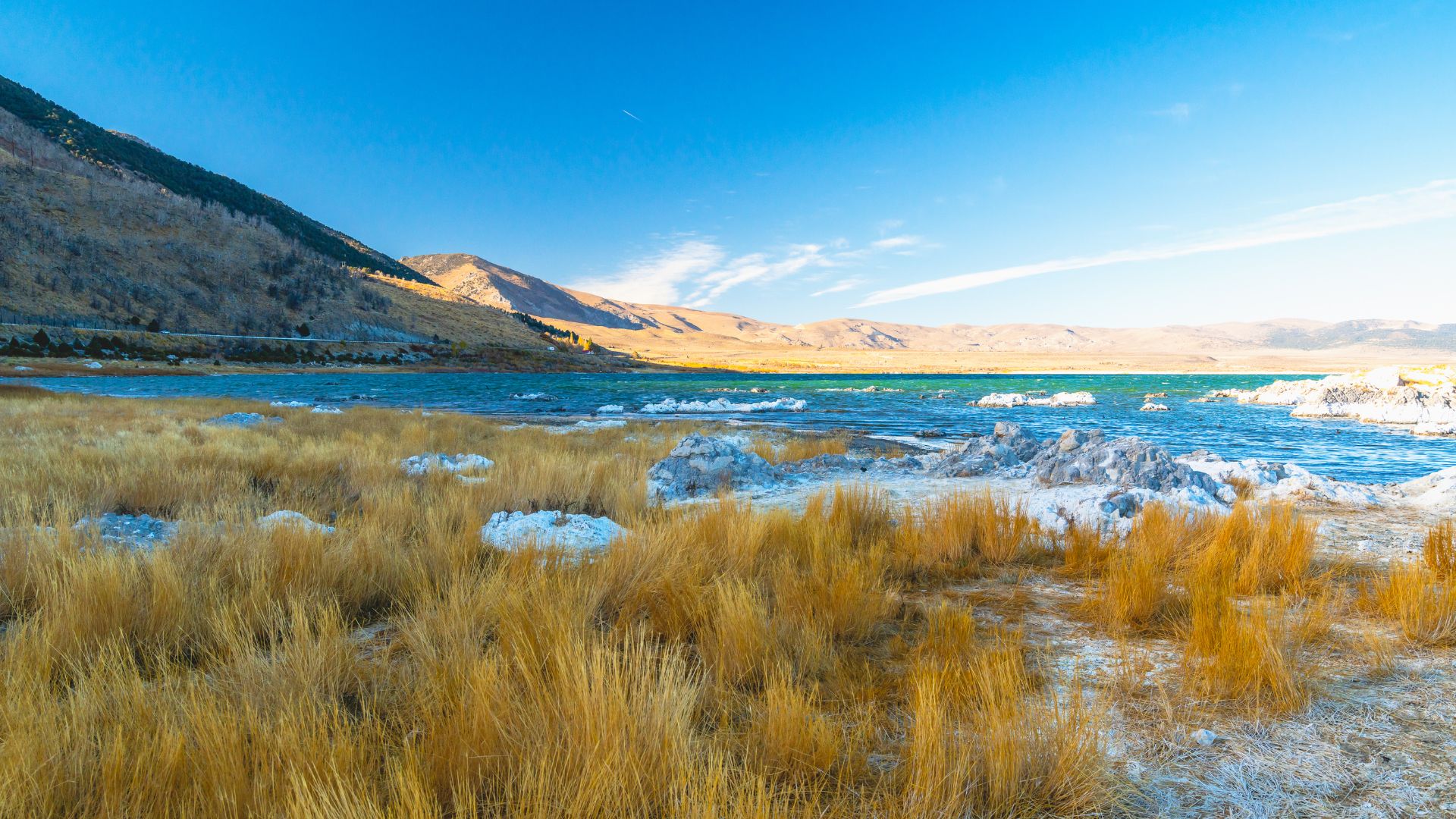
Mono Lake is one of California’s weirdest and most fascinating natural wonders. Its limestone tufa towers rise from salty, alkaline water like something from another planet. The light here at sunrise and sunset is unreal, and Bodie State Historic Park is just up the road.
Tufa Formations and Tufa Towers
The first time I saw Mono Lake’s tufa towers, I just stood there, slack-jawed. These limestone columns form when calcium-rich springs bubble up into the alkaline lake, building the towers inch by inch over centuries.
The South Tufa Area is the easiest place to check them out. A short trail winds through dozens of towers, some over 30 feet tall. The mix of white rock and deep blue water is just wild.
Navy Beach gives you a different angle. You can wade into the shallow water and see tufa formations below the surface. It feels like walking on another planet, and the salty water makes you float whether you want to or not.
Best viewing spots:
- South Tufa Area (easy access)
- Navy Beach (wade right in)
- Mono Lake County Park (boardwalk views)
Sunrise and Sunset Photography
Mono Lake turns into a photographer’s playground at golden hour. The tufa towers mirror perfectly on the still water, doubling the drama.
Sunrise at South Tufa is my favorite. The limestone glows orange and pink as the sun comes up. I usually get there half an hour before sunrise to claim a good spot. The light changes fast, so every few minutes you get a whole new look.
For sunset, Navy Beach is the place. The Sierra Nevada frames the sun as it drops. I like to bring a tripod and play with long exposures—the water smooths out and the towers look even more surreal.
Photography tips:
- Get there early for the best spots
- A polarizing filter cuts glare
- Wide-angle lens helps fit it all in
- Pack warm layers—it gets chilly fast
Nearby Ghost Towns: Bodie State Historic Park
Bodie State Historic Park sits about 20 miles north of Mono Lake. This preserved ghost town lets you step straight into California’s gold rush era.
Honestly, it feels like the perfect side trip if you’re already at Mono Lake. Over 100 buildings stand in what’s called “arrested decay.”
Park rangers keep the structures stable but don’t restore them. When I wandered through Bodie, it really felt like 1880 was just yesterday.
Some houses still have old furniture, dishes, even personal items—it’s a little eerie, but fascinating. I spent three hours poking around the main street, the old schoolhouse, and the cemetery.
The Methodist Church and Miners’ Union Hall really show what life was like in this once-bustling mining town. At its peak, more than 10,000 people called Bodie home.
Visitor information:
- Open seasonally (closed in winter)
- $8 entrance fee for adults
- Last 3 miles on unpaved road
- Allow 2-3 hours for full exploration

Unforgettable Natural Wonders and Outdoor Adventures
The Eastern Sierra has three natural wonders that always surprise me with their variety. Waterfalls, geothermal spots, and wild mountain passes—it’s a region that just keeps giving.
You won’t find these experiences anywhere else in California. It’s wild, sometimes unpredictable, and always worth the trip.
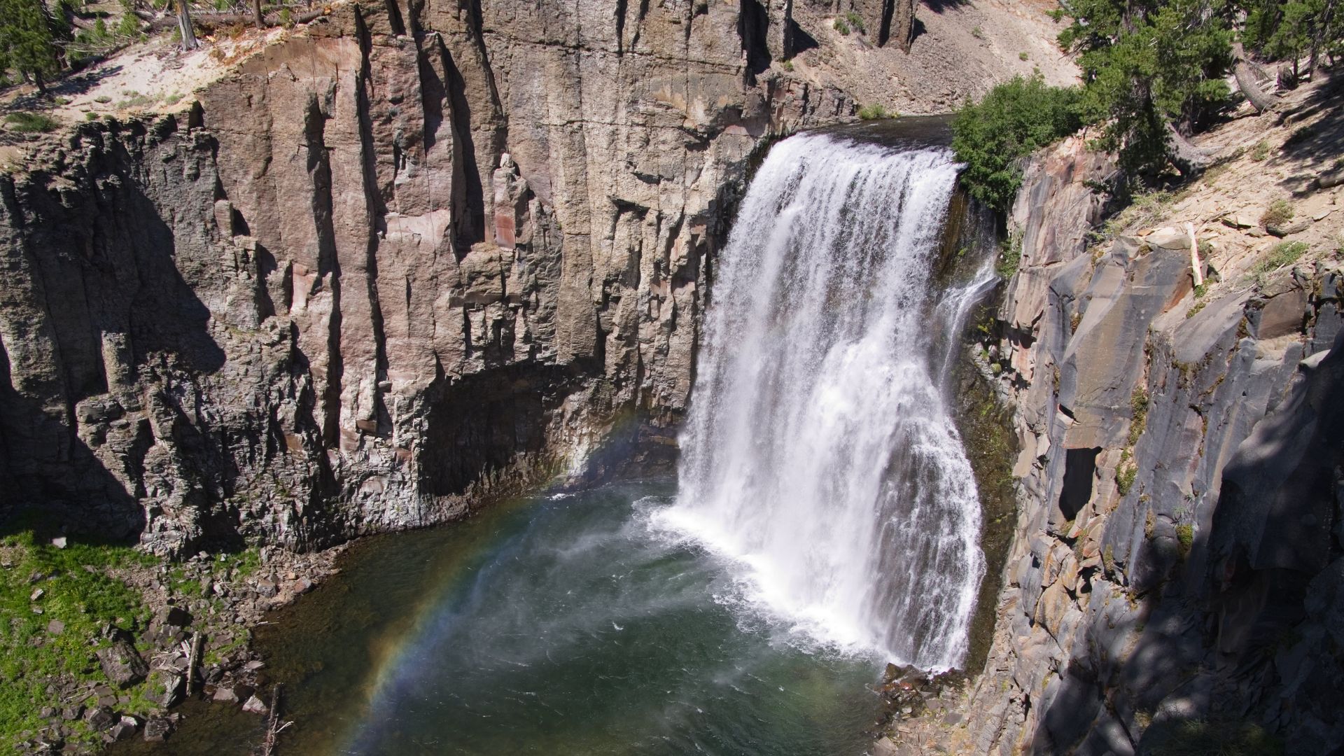
Rainbow Falls: Waterfall Magic
Rainbow Falls is hands-down one of the most spectacular waterfalls in the Eastern Sierra. The water plunges 101 feet over a granite cliff inside Devils Postpile National Monument.
If you ask me, the best time to visit is midday. Sunlight hits the mist, and suddenly rainbows are everywhere.
Getting There:
- 5-mile round trip hike from Devils Postpile
- Moderate difficulty level
- Best visited June through October
The trail follows the San Joaquin River through thick forest. Bring a camera—if you have a polarizing filter, even better.
Spring snowmelt makes the waterfall roar, but even in late summer, it’s still a sight. The water volume drops, but you won’t leave disappointed.
Hot Creek Geologic Site
Hot Creek is where the area’s volcanic personality really shows up. Bubbling hot springs and steam vents pop up in a mountain valley, and the whole place feels almost otherworldly.
I watched boiling water gush up from underground springs, sometimes reaching 180 degrees. The mix of hot springs and icy creek water creates a wild, surreal scene.
What to Expect:
- Wooden boardwalks for safe viewing
- Educational signs about geothermal activity
- No swimming allowed (seriously, it’s dangerous)
Geologists use this spot to study volcanic activity. Turns out, the heat comes from magma deep below the surface.
If you want dramatic photos, come in the morning. The steam rises thickest when the air’s cool.
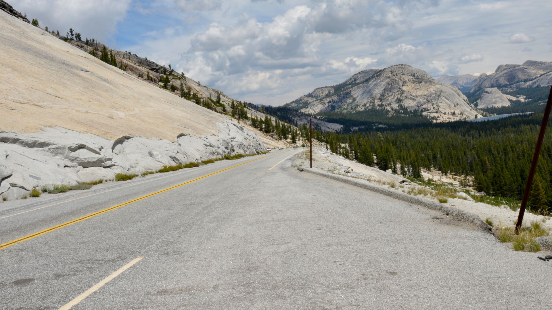
High-Altitude Passes: Tioga Pass and Alpine Meadows
Tioga Pass, at 9,943 feet, connects the Eastern Sierra to Yosemite National Park. This high mountain road opens up a world of alpine meadows and wildflowers.
The pass usually opens in late May or June, depending on snow. The wildflower show is short but intense, peaking in July and August.
Alpine Meadow Highlights:
- Tuolumne Meadows: Huge subalpine grassland
- Dana Meadows: Smaller and feels more hidden
- Lembert Dome: Granite dome that’s great for hiking
High elevation means the growing season barely lasts a few months. During peak bloom, I saw fields of lupine, paintbrush, and mountain aster.
Planning Tips:
- Always check road conditions before you go
- Bring layers—the weather changes fast
- Start hikes early to dodge afternoon thunderstorms
Once winter hits, snow closes the pass completely.
Seasonal Wonders and Unique Experiences
The Eastern Sierra seems to reinvent itself every season. Fall brings an explosion of color, while summer opens up the lakes and high country.
Eastern Sierra Fall Colors
September and October turn the region into a painter’s dream. Aspen groves along Highway 395 burst into gold and yellow.
Some of my favorite spots are near Convict Lake and along the June Lake Loop. The mix of golden aspens and dark evergreens is a photographer’s dream.
Prime Fall Color Locations:
- June Lake Loop (Highway 158)
- Convict Lake area
- McGee Creek Road
- Lundy Canyon
Colors usually peak in late September at higher elevations. Lower spots catch up about a week later.
Weather can shift the timing, though. Cold nights and sunny days seem to make the colors pop the most.
Kayaking and Paddleboarding Hotspots
Summer turns the Eastern Sierra’s lakes into the ultimate playground. I’ve paddled a bunch of these alpine lakes, and each one feels a little different.
Top Paddling Destinations:
- Convict Lake: Calm water, epic mountain views
- June Lake: Easy rentals and access
- Silver Lake: Fewer crowds, gorgeous reflections
- South Lake: High elevation, super clear water
June Lake is the easiest for rentals and launching. Mornings are best—the wind usually picks up later.
Convict Lake always takes my breath away. If you love paddleboarding with a view, the mirrored peaks in the morning are unforgettable.
Hidden Alpine Trails and Lakes
The high country keeps its secrets close, only sharing them with those who actually lace up their boots and wander off the main path. I’ve stumbled upon some amazing alpine lakes that most folks never even hear about, let alone see.
Must-Visit Alpine Lakes:
- Long Lake: You’ll find it along the Bishop Pass Trail.
- Emerald Lakes: Tucked away above South Lake—these really feel like hidden treasures.
- Thousand Island Lake: Only accessible if you’re up for an overnight backpacking adventure.
- Ruby Lake: Perfect for a day hike from Little Lakes Valley.
Long Lake sits way up at 10,800 feet. The views of the Palisades? Absolutely wild. You get there by hiking about five miles from South Lake. It’s a bit of a workout, sure, but I think most hikers can handle it if they take their time.
Ruby Lake is a little friendlier on the legs. The trail’s only about three miles, winding through a gentle valley dotted with smaller lakes. I always end up stopping just to soak in the quiet.
Snow and ice usually linger on these lakes until late June. If you want the best hiking weather and maybe even a quick dip, July through September is your sweet spot.