Just west of Lone Pine, California, the Alabama Hills rise from the desert floor like a movie set frozen in time.
This wild landscape has played host to more than 400 films, and it’s a dream for anyone who loves exploring quirky rock formations, natural arches, and the famous Mobius Arch Loop Trail.
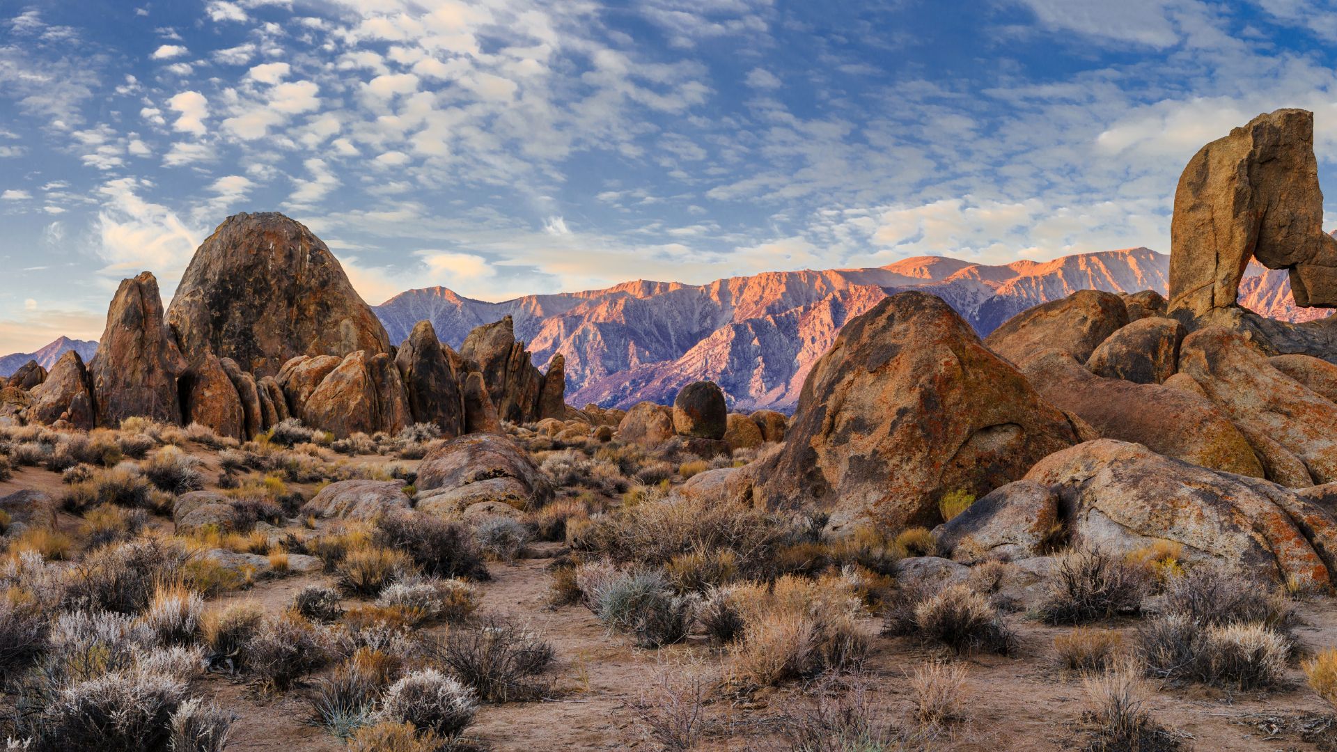
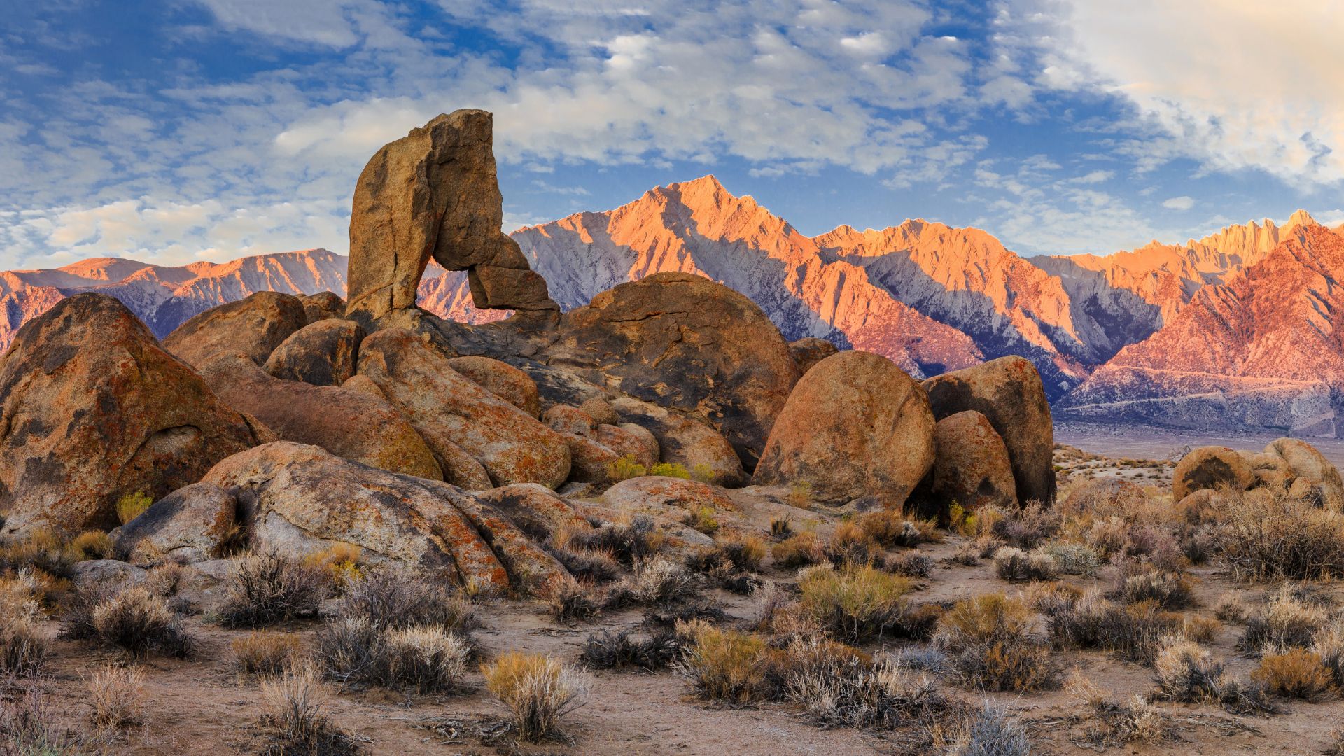
The golden granite boulders against the snow-capped Sierra Nevada mountains? It’s honestly one of California’s most striking desert destinations.
I’ve wandered these hills and found myself caught between Hollywood nostalgia and raw, rugged beauty.
The Alabama Hills sit just off Highway 395, so they’re super easy to reach—no crowds, no fuss, just wide-open adventure.
Whether you’re following the footsteps of movie stars or just craving an easy hike with epic views, this place delivers.
From cruising along Movie Road to scrambling up ancient boulders, you’ll find plenty of ways to stretch your legs and imagination here.
With year-round access and the mighty Eastern Sierra right next door, it’s the perfect launchpad for both desert wanderings and mountain escapades.
Discovering Alabama Hills and Its Cinematic Legacy
For over a century, Alabama Hills have starred as Hollywood’s backdrop.
Their wild shapes and golden glow have appeared in more than 400 films and TV shows.
This rugged landscape near Lone Pine picked up its name from Civil War-era mining claims and quickly became the defining location for Westerns.
History and Naming of Alabama Hills
During the Civil War, Confederate sympathizers mining here named their claims after the C.S.S. Alabama, a Confederate warship famous for attacking Northern ships.
But the Alabama’s glory days didn’t last.
In 1864, the U.S.S. Kearsarge sank the Alabama off Normandy’s coast in a dramatic gun battle.
Union supporters in the area fired back in their own way.
They named a mining district, a mountain pass, a peak, and even a town “Kearsarge” to honor the Union victory.
So, the region ended up with a patchwork of names that reflect both sides of the conflict.
The Alabama Hills kept their Confederate connection, while nearby Kearsarge features salute the Union.
Famous Films and TV Shows Shot Here
Movie studios rolled in during the 1920s and just kept coming back.
Directors loved the dramatic rocks and the bright, clear desert light.
Classic Western stars like Tom Mix, Hopalong Cassidy, Gene Autry, and the Lone Ranger filmed right here.
Locals even started calling the area “Movie Flats” because it seemed like someone was always shooting a film.
Some big-name movies and shows that filmed here:
- Gunga Din (1939)
- How the West Was Won (1962)
- Star Trek Generations (1994)
- Iron Man (2008)
- Django Unchained (2012)
Even now, filmmakers pick Alabama Hills for everything from quirky monster flicks like Tremors to modern superhero blockbusters.
Movie Road cuts right through the heart of it all.
You can drive along and spot the same views that once filled cinema screens.
Role of Alabama Hills in Western Cinema
Alabama Hills basically shaped how we all picture the Old West.
Those rounded granite shapes and the jagged Sierra backdrop? Instantly iconic.
Directors couldn’t resist the contrast.
Every shot looked epic, almost larger than life.
It helped that Lone Pine made it easy for crews to get in and set up, and the desert air meant perfect lighting.
Over 400 productions have used these rocks as their set.
No other spot in America has shown up in more Westerns.
The film legacy is alive and well.
Every October, Lone Pine throws a big Film Festival to celebrate its movie history.
If you wander the hills, you’ll spot photo plaques marking the exact spots where famous scenes were shot.
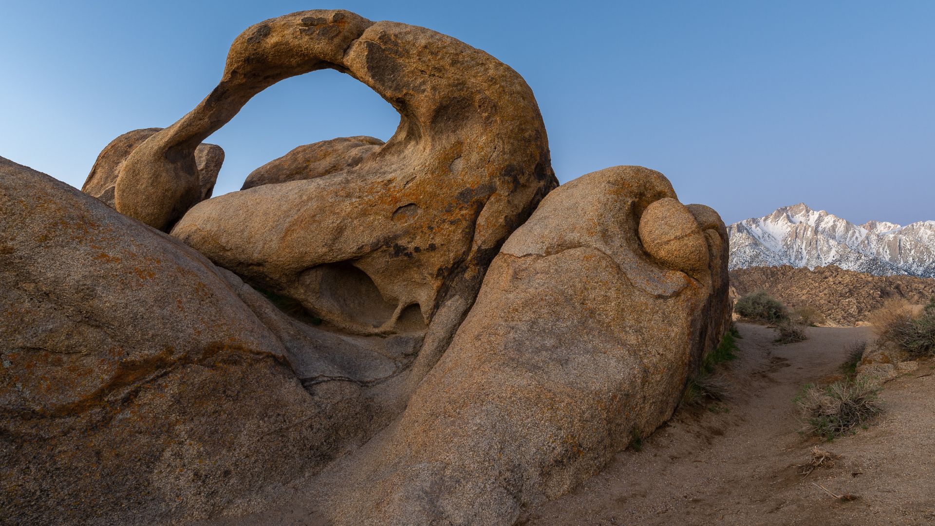
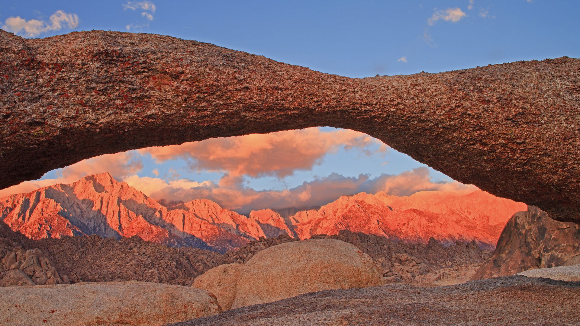
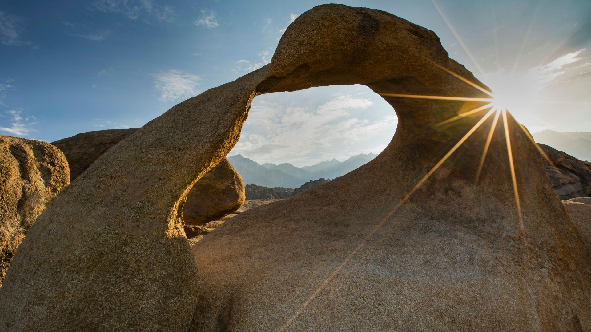
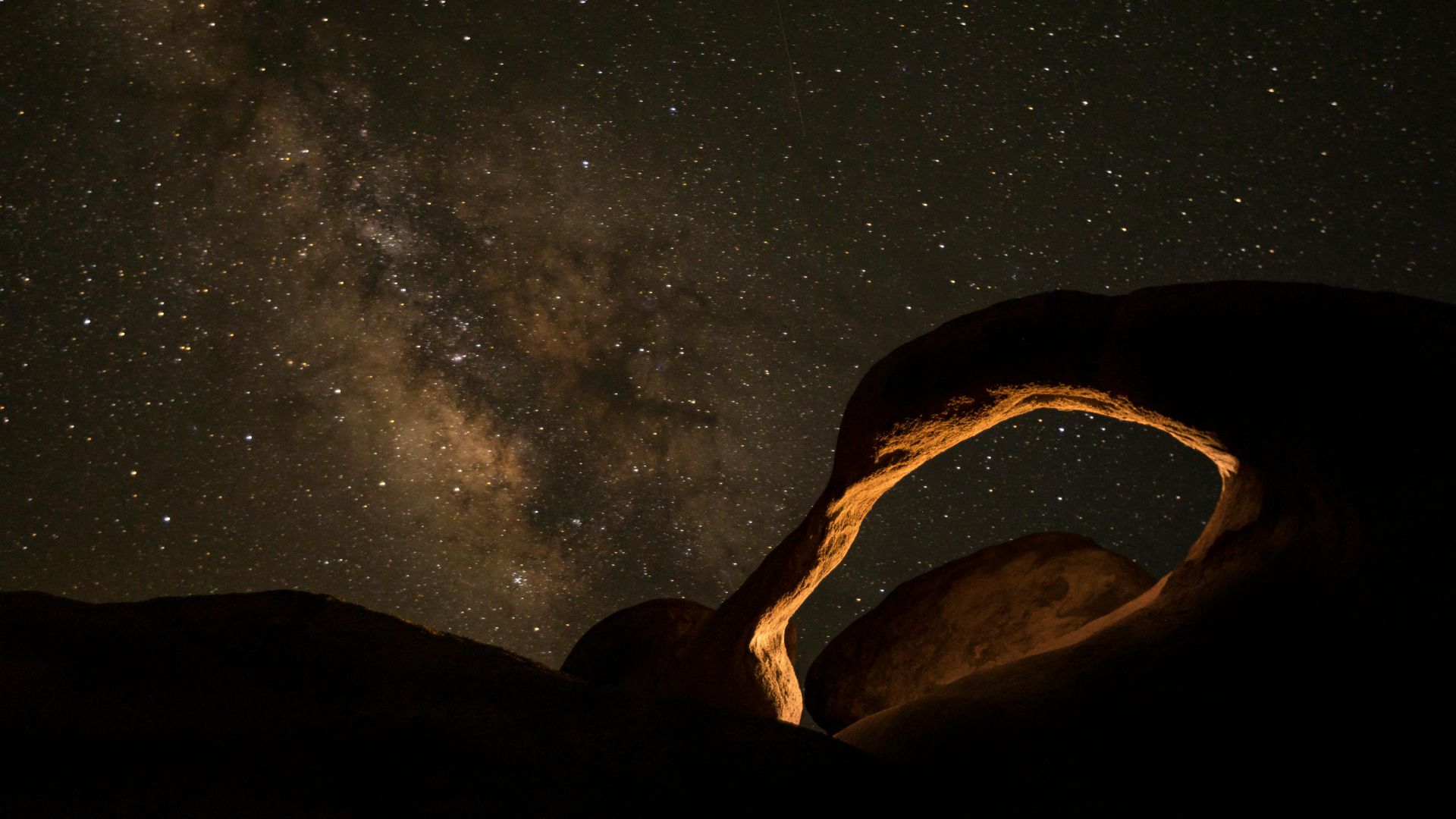
Mobius Arch: The Iconic Natural Wonder
Mobius Arch stands out as the Alabama Hills’ most famous natural rock formation.
It’s about 6 feet high and 17 feet across—a perfect granite window framing Mount Whitney.
Honestly, it’s one of the best photo ops in the Sierra Nevada.
Mobius Arch Loop Trail Guide
The Mobius Arch Loop Trail is short—just half a mile.
It’s a breeze for hikers of all abilities.
You’ll find the trailhead off Movie Road, about 2.5 miles west of Lone Pine along Whitney Portal Road.
Here’s how you get there:
- Take Highway 395 to Lone Pine
- Turn west at the stoplight onto Whitney Portal Road
- Drive 2.5 miles, then turn right onto Movie Road
- Go 1.5 miles to the “Y” intersection, turn right, and park in the dirt lot on your left
Trail markers line both sides of the parking area.
Since it’s a loop, you can start from either end.
The path winds through classic desert plants—think barrel cactus and desert needle grass.
Expect sandy washes and granite boulders underfoot.
If you use mobility equipment, plan ahead since the trail width changes.
Most folks finish the hike in 30 to 45 minutes if you take it slow.

Best Times for Visiting and Photography
If you’re after killer photos, aim for golden hour—just before sunset or right after sunrise.
That warm light really makes the rocks glow and the shadows pop.
Best times for photos:
- Sunrise: 30 minutes before to 1 hour after
- Sunset: 1 hour before to 30 minutes after
- Blue Hour: 20-30 minutes after sunset
Winter brings the clearest views of snow-capped Mount Whitney.
Spring is great for wildflowers.
Summer? It gets hot, so go early if you can.
The arch faces east, which makes sunrise shots especially magical.
At sunset, swing around to the west side and you’ll catch the mountains glowing in the evening light.
Mobius Arch and Mount Whitney Views
Mobius Arch frames Mount Whitney, the tallest peak in the lower 48 at 14,505 feet.
From some angles, you can also spot Lone Pine Peak through the arch.
Wind and time carved the granite into this smooth, curved window, kind of like a mobius strip—hence the name.
It’s roughly 17 feet wide and 6 feet tall.
Photo tips:
- Bring a wide-angle lens to fit the arch and mountains in the shot
- Add some foreground rocks for extra depth
- Move around and try different frames—each angle offers something new
- Please don’t climb on the arch; let’s keep it around for future visitors
The warm granite against the snowy Sierra makes for unforgettable photos.
Mount Whitney’s east face rises over 10,000 feet above the valley, so you’re in for a dramatic view.
Exploring Alabama Hills: Top Rock Formations and Scenic Drives
Alabama Hills packs in dozens of quirky rock formations and natural arches.
You can reach most of them via two main scenic routes.
Movie Road is the classic for photography, while Whitney Portal Road gives you those big mountain vistas.
Notable Rock Formations and Natural Arches
Mobius Arch is the star of the show.
If you want that iconic sunrise shot, get there early to catch the alpenglow on Mount Whitney and Lone Pine Peak through the arch.
The 0.6-mile Mobius Arch Loop Trail starts from Movie Flat Road at a marked lot.
It’s mostly easy, with just a bit of climbing.
Lathe Arch sits close by on the same loop.
It’s smaller and hugs the ground, but frames the Sierra beautifully.
Heart Arch is visible from the Mobius Arch parking area.
Take the right fork in the trail instead of left and you’ll find it.
Eye of the Alabama Hills Arch is easy to spot from Movie Flat Road.
There are pullouts nearby for a quick stop.
Boot Arch looks like—well, a lady’s boot.
It’s farther down Movie Flat Road and makes for fun photos, day or night.
Movie Road: Route, Landmarks, and Photo Spots
Movie Road starts as Movie Flat Road, just off Whitney Portal Road, about 2.7 miles east of Lone Pine.
After you pass the Eye of the Alabama Hills Arch, it becomes Movie Road.
This 12-mile dirt road usually works for regular cars if it’s dry.
But after rain or snow, check conditions first.
Look out for these landmarks:
- Movie Plaque celebrating Hollywood history
- Roy Rogers Movie Flats filming site
- Lone Ranger Canyon
- Gunga Din Canyon
The straight stretches of Movie Road are perfect for those classic photos with the Sierra in the background.
Go early or late for the best light and fewer people.
Most roads here aren’t marked, but you can explore side routes if you’re careful and the weather’s good.
The Lone Pine Visitor Center always has the latest road info and can help with directions.
Whitney Portal Road and Scenic Overlooks
Whitney Portal Road is your main way into Alabama Hills from Lone Pine.
After about 2.5 miles, you’ll hit the Alabama Hills Recreation Area entrance.
Whitney Portal Arch sits right along this road.
You can spot it from your car, and there’s a trailhead parking area just over 5 miles from town.
The trail to Whitney Portal Arch gives you wide-open views of Mount Whitney and the whole Sierra range.
It’s usually less crowded than spots along Movie Road.
Whitney Portal Road keeps climbing up to the Whitney Portal trailhead.
Along the way, you’ll find pullouts perfect for photos or just soaking in the scene.
If you’re up for a little adventure, take one of the unnamed dirt roads branching off to discover quiet corners and new rock formations.

Outdoor Adventures: Hiking, Camping, and Recreation
Alabama Hills offers free dispersed camping with jaw-dropping Sierra views, easy hiking trails like Mobius Arch, and outdoor fun all year long.
Spring and fall bring the best weather for exploring.
Hiking Trails for All Skill Levels
You’ll find several easy trails here—great for hiking newbies and photographers alike.
Mobius Arch Loop is the favorite.
It’s only 0.6 miles and takes about half an hour, but the payoff is huge.
The trail leads straight to that famous arch framing Mount Whitney.
Bring a camera—the views are unreal.
The trailhead sits about 1.5 miles off Movie Road, and signs make it easy to find.
Other ways to explore:
- Scramble around the wild granite boulders
- Hunt for hidden arches scattered across the hills
- Take a photo walk along Movie Road
- Link up with trails heading into the Sierra if you want a bigger challenge
Most hikes here are gentle, with sandy paths and smooth rocks underfoot.
You don’t need to be a pro hiker to enjoy them.
Camping and Stargazing in Alabama Hills
Camping here is all about freedom and big skies.
You can camp pretty much anywhere that’s seen use before, though new rules limit camping on the west side of Movie Road.
What to know:
- No water or bathrooms, so pack it all in and out
- There are six porta-potties scattered around
- Fires need a permit when allowed
At night, the stars are incredible.
Lone Pine is tiny, so there’s barely any light pollution, and Death Valley lies just to the east.
Bring extra water and supplies—the nearest store is 10 minutes away in Lone Pine.
Most campsites tuck behind big boulders for privacy.
You’ll need a free permit to camp now, so check the BLM website before you go.
Best Seasons and Weather Tips
Spring (March through May) is prime time.
Days are comfy, nights are cool, and the Sierra still wears its snowy crown.
Fall’s just as nice—mild days, crisp nights, and clear skies.
Summer? It gets scorching, and winter nights can be brutally cold.
Quick weather breakdown:
- Spring: 60-80°F days, 40-50°F nights
- Summer: Really hot, not great for camping
- Fall: Pleasant and dry
- Winter: Mild days, freezing at night
If you’re not a fan of extreme heat, skip summer.
Winter camping is doable if you’re ready for cold temps.
No matter when you visit, pack layers—the desert loves to surprise you with big swings between day and night.
Planning Your Visit: Access, Safety, and Nearby Attractions
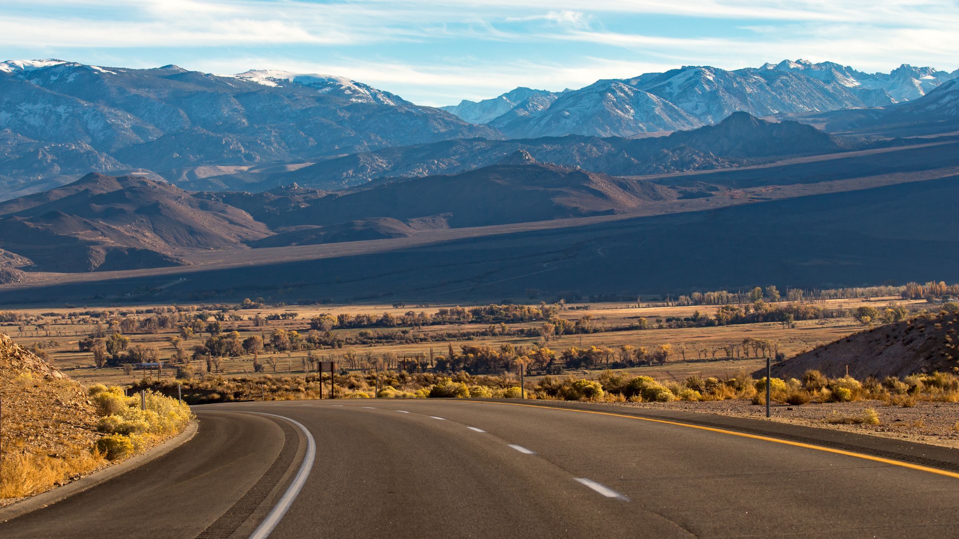
Alabama Hills sits just off California’s Highway 395, not far from Lone Pine. You can get there by car pretty easily from most major cities.
The area’s got a rugged, wild vibe, so you’ll want to prep for desert conditions and some bumpy roads. Don’t expect city comforts out here.
How to Get There: Highway 395 and Lone Pine
Honestly, Highway 395 is the way to go if you’re heading for Alabama Hills. It’s straightforward and scenic, winding up through some dramatic landscapes. From Los Angeles, you’re looking at about three and a half hours north. If you’re coming from Las Vegas, plan on a four-hour drive west.
Highway 395 cuts right through Lone Pine, which feels like the unofficial front door to Alabama Hills. When you hit Lone Pine, just swing west onto Whitney Portal Road. That road will take you straight into the heart of the Alabama Hills.
Parking and Access:
- No entrance fees at all
- Plenty of dirt pullouts along Whitney Portal Road
- Main trailheads have their own parking spots
- Regular cars can manage the main roads just fine
If you want to check out the more remote corners, I’d go for a higher-clearance vehicle. Dirt roads aren’t always friendly to low cars, and you might end up wishing for 4WD if you wander off the main drag. Still, the big sights like Mobius Arch don’t need anything fancy.
Visitor Guidelines and Conservation
The Bureau of Land Management keeps an eye on Alabama Hills since it’s public land. I always try to stick to Leave No Trace principles—this place is delicate, and it’s easy to leave a mark if you’re not careful.
Essential Safety Items:
- Extra water (I’d say at least a gallon per person)
- Sunblock and a decent hat
- Layers—desert temps swing wildly
- First aid kit and some basic emergency stuff
Desert weather can be no joke. Daytime highs in summer often top 90°F, but winter nights? They can dip to 40°F or lower. It’s a bit unpredictable, honestly.
Before you head out, check the weather. Storms can bring wild winds or even flash floods, and every so often, winter throws a snowstorm at the area.
Stick to marked trails. The landscape’s fragile, and it’s easy to do real damage by wandering off-path or scrambling on the rocks. Try not to bother the wildlife, and always pack out your trash—yes, even the tiny stuff.
Nearby Natural Wonders and Day Trips
Plenty of major attractions sit within easy driving distance of Alabama Hills. When I plan a trip out here, I usually tack on a few extra stops nearby.
Mount Whitney rises just west of Alabama Hills. The Whitney Portal Road winds past the hills and heads straight to the trailhead.
This peak actually claims the title of highest in the contiguous United States—14,505 feet. That number never fails to impress me.
Manzanar National Historic Site sits about 10 miles north along Highway 395. Walking through this former World War II internment camp, you really feel the weight of history and the stories of Japanese American detention.
The Sierra Nevada mountains create a jaw-dropping backdrop for Alabama Hills. You’ll find several hiking trails that give you easy access to the eastern Sierra right from this area.
Death Valley National Park sits about two hours south if you take Highway 395. Honestly, it’s worth stretching your trip out for this one—trying to cram it into a single day just doesn’t do it justice.
Joshua Tree National Park is a longer drive to the southeast. But if you’re up for a multi-day adventure, pairing it with Alabama Hills makes for a pretty unforgettable California desert road trip.