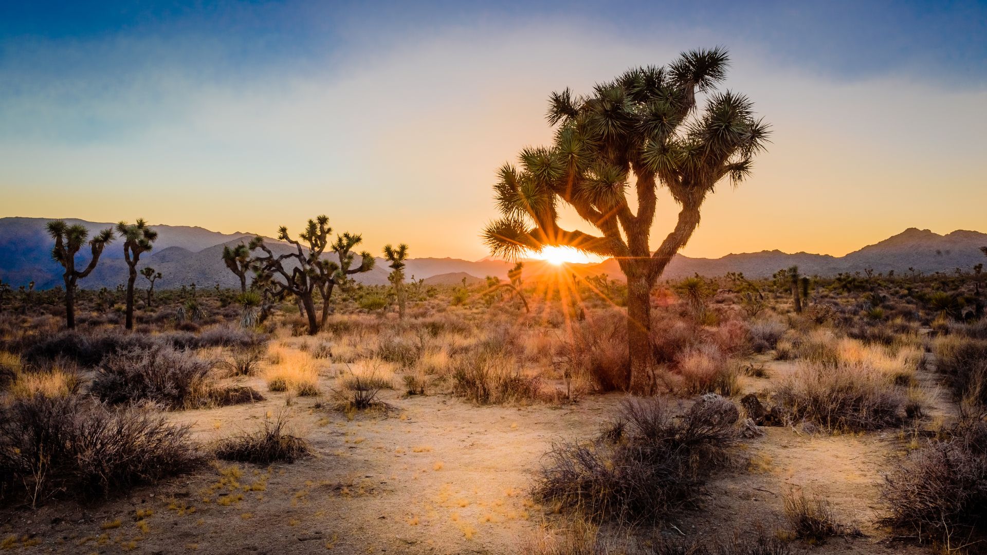
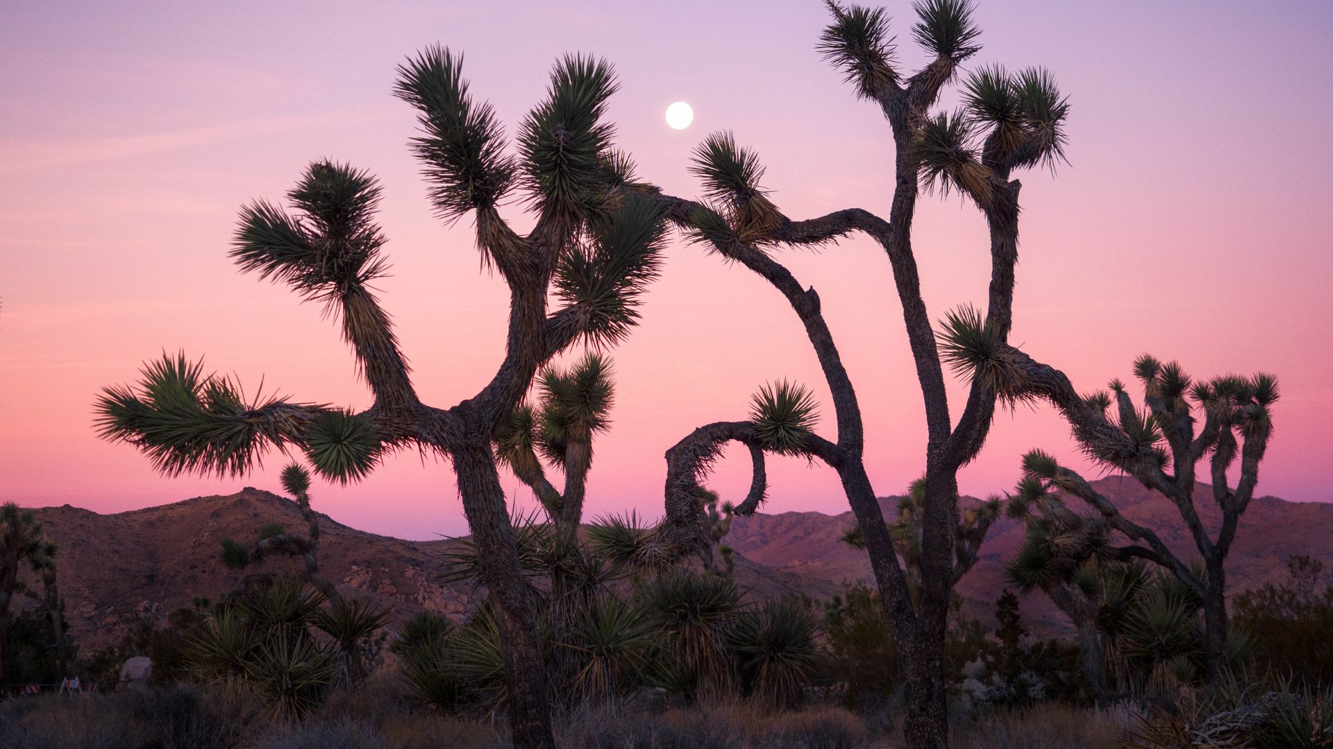
Joshua Tree National Park in California truly feels like another world. Those bizarre, twisty trees? They remind me of something straight out of a Dr. Seuss book. The wild mix of Joshua trees, giant boulders, and wide-open desert creates a sense of adventure with every step.
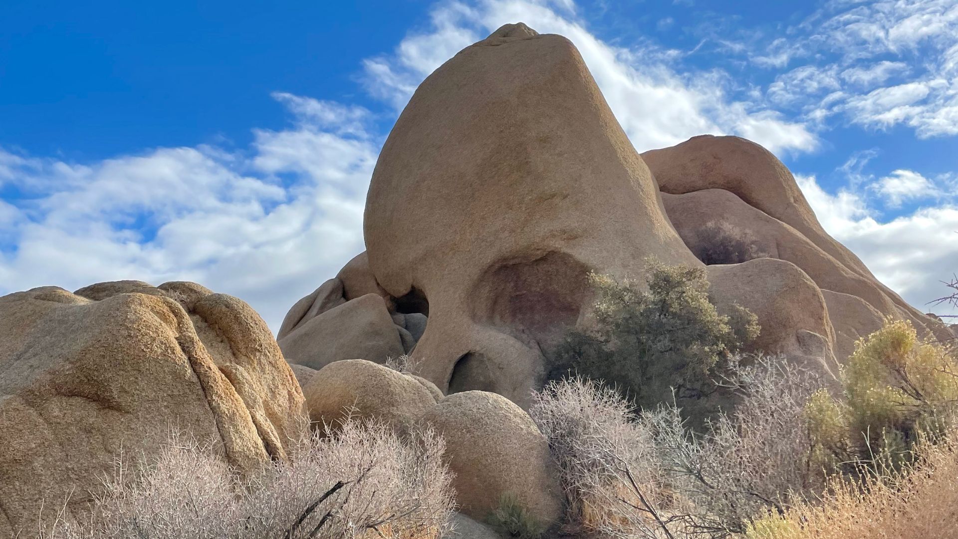
Skull Rock sits right by the road, almost daring you to stop and snap a photo. It’s hard to resist.
At night, the sky fills with stars, turning the darkness into an unforgettable show. I remember finding a rare kind of peace out there, surrounded by vastness and silence. Joshua Tree isn’t just about what you see—it’s about how tiny you feel under that endless sky, and how weirdly beautiful everything looks.
Joshua Tree National Park’s Enchanting Landscapes
The park threw me into the heart of two different desert ecosystems, each with dramatic plants and massive rock formations. Wildlife darted between granite boulders and hid beneath those storybook trees.
Mojave and Colorado Desert Ecosystems
Joshua Tree National Park sits right where the Mojave and Colorado deserts collide. On the west side, the higher Mojave Desert sprawls out, dotted with those iconic Joshua trees.
The eastern side drops into the lower, warmer Colorado Desert. Here, creosote bushes, cholla cactus gardens, and sandy flats take over.
As I drove across the park, I noticed the shift—temperatures, plants, even the color of the rocks changed. This meeting of deserts creates an odd but fascinating mix of life you won’t find anywhere else.
The Iconic Joshua Trees and Other Flora
The Joshua tree (Yucca brevifolia) steals the show in the Mojave. With its twisted arms and spiky leaves, it’s easy to see why people compare it to Dr. Seuss’s creations.
These trees only grow in the Mojave, which gives the park its name. In spring, some bloom with creamy flowers. I spotted Mojave yucca, cholla cactus, and wiry ocotillo too.
Every plant here seems to have its own survival trick for the dry desert. After rare rains, wildflowers sometimes burst across the sand, bringing color and drawing in bees and birds.

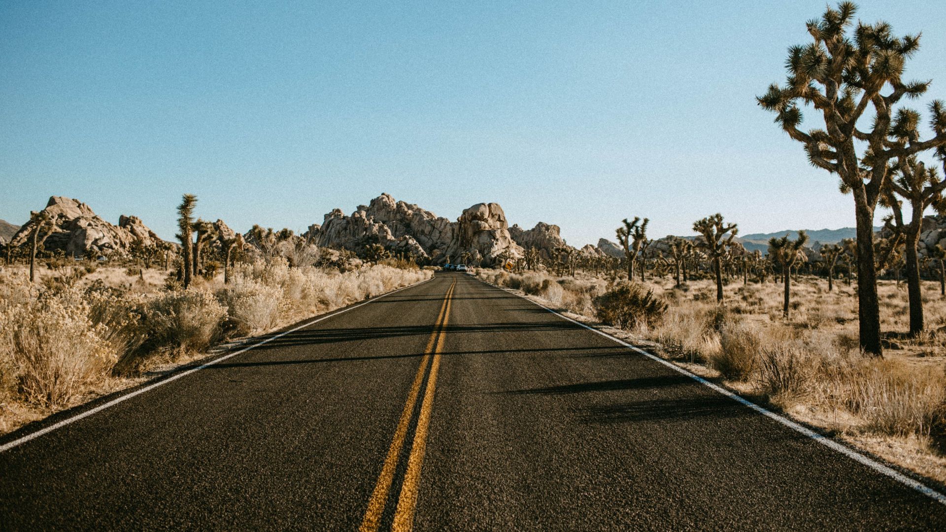
Unique Granite Rock Formations
Granite boulders and rock piles sprawl across parts of the park, attracting visitors from all over. These rocks started as molten magma millions of years ago. Wind and rain shaped them into smooth curves and stacks.
Some formations have quirky names—Skull Rock, Arch Rock—because they’re just that weird. I climbed over boulders and squeezed through tight gaps, feeling like a kid again.
Rock climbers flock here for good reason. At sunrise and sunset, the rocks glow with pink and beige tones, always looking a little different. Erosion’s still at work, slowly changing the shapes.
Wildlife and Natural Wonders
Even with so little water, animals thrive here. I saw jackrabbits dart between bushes and lizards sunning themselves on warm stones.
Hawks, roadrunners, and sometimes golden eagles soar overhead. Coyotes yip at night, and kangaroo rats scurry for seeds. Bighorn sheep hide in rocky spots—early mornings are your best bet to spot them.
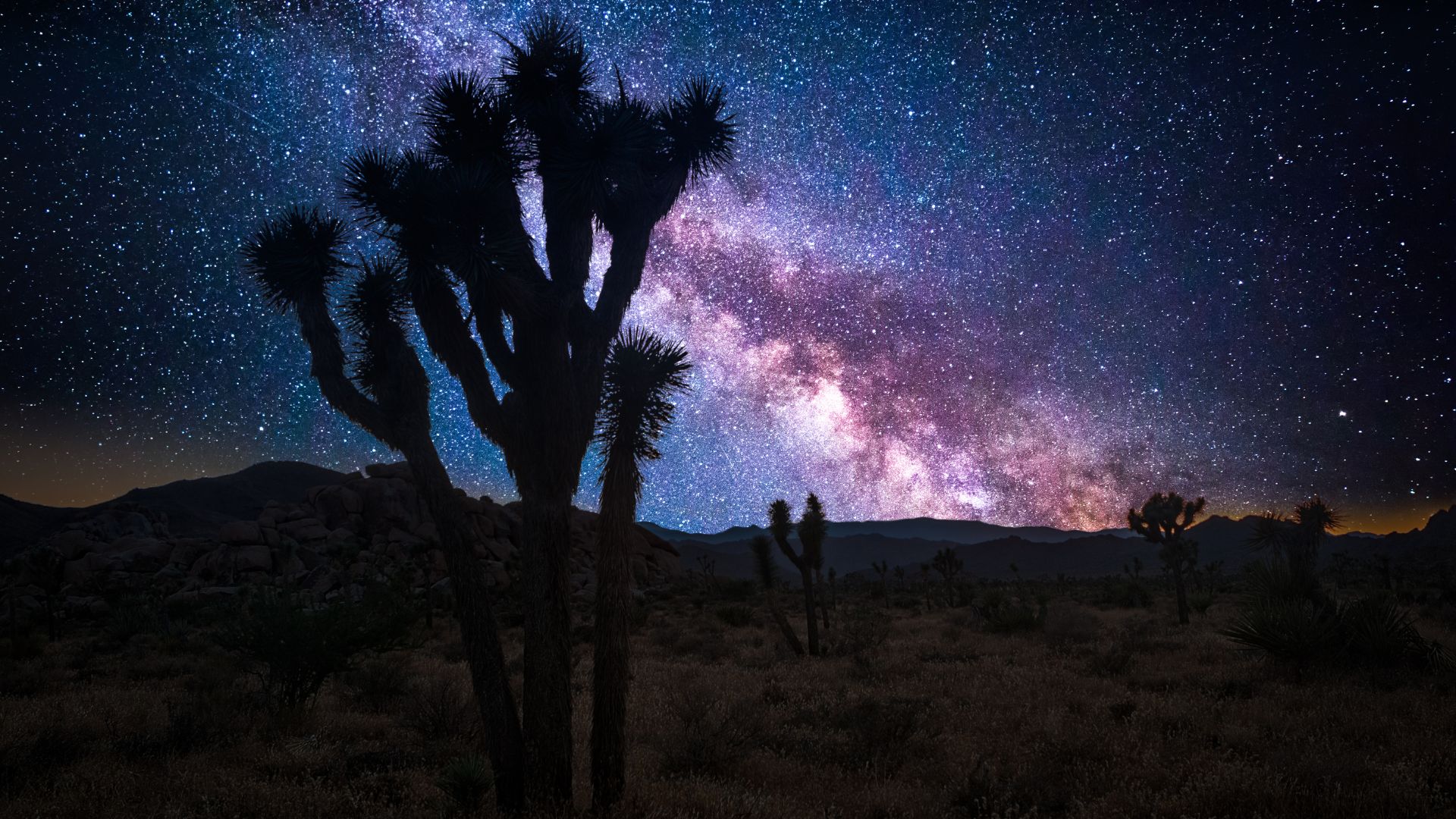
After sunset, the sky explodes with stars. I counted thousands, and the Milky Way arched overhead. Most wildlife hides from the heat, but if you slow down and look, you’ll notice life everywhere.
Must-See Attractions and Mystical Sights
Joshua Tree National Park offers a wild mix of landscapes, rock formations, and desert plants. Each spot has its own vibe, from giant boulders and cactus gardens to epic viewpoints and quiet trails.
Skull Rock and Jumbo Rocks
I kicked things off at Skull Rock. Its face, with hollowed “eye sockets,” looks eerily like a giant skull. It’s right off the main road, so you can hop out for a quick look or photo.
Not far away, I wandered through the Jumbo Rocks area. Huge, rounded boulders scatter across the desert, forming a natural playground. I watched families climbing, photographers chasing the light, and couples picnicking among the rocks.
Here’s a quick table with highlights:
| Site | What Stands Out | Good For |
|---|---|---|
| Skull Rock | Skull-shaped boulder | Quick stops |
| Jumbo Rocks | Giant round boulders | Climbing, photos |
Both spots work great for easy walks and catching sunrise or sunset.
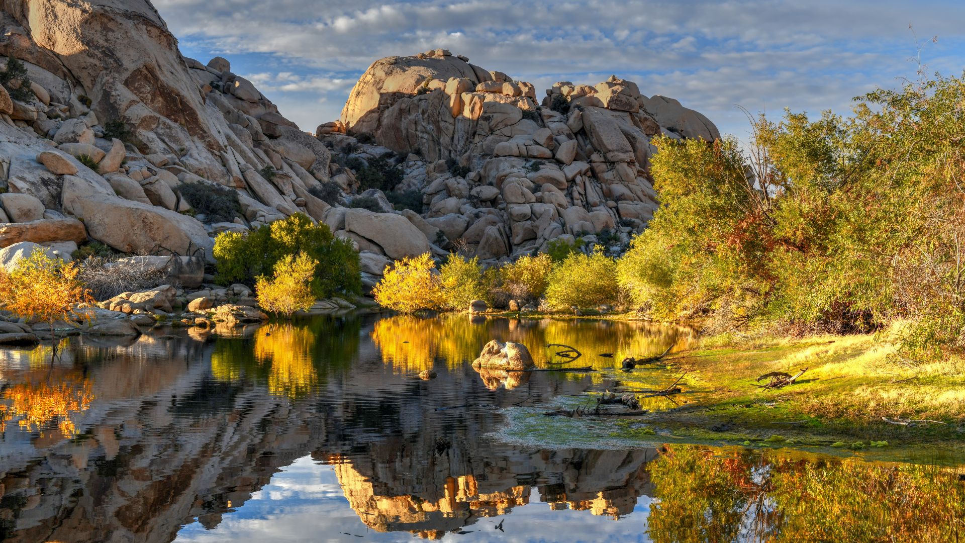
Hidden Valley and Barker Dam
Walking the Hidden Valley loop felt like discovering a secret garden. Tall rocks surround this spot, and local legends say cattle rustlers once hid here. The hike’s about a mile, and I loved watching birds and lizards slip between the boulders.
Barker Dam surprised me with water in the middle of the desert. The easy trail led to a small lake, reflecting rocks and Joshua trees. In spring, the dam sometimes fills up, making it perfect for spotting bighorn sheep and snapping photos.
These trails are ideal for families and first-timers. I appreciated the interpretive signs—they really helped me understand the plants and stories behind each place.
Cholla Cactus Garden and Hall of Horrors
The Cholla Cactus Garden was just surreal. Thousands of “teddy bear” cholla cacti crowded the valley floor. I quickly learned to keep my distance—those spines are no joke! Early morning or late afternoon is best, when the light turns the cacti golden.
The Hall of Horrors sounds spooky, but it’s mostly just fun. I squeezed through narrow rock passages and explored shady nooks. Climbers love this spot for its quirky challenges, and it’s not far off the main road.
The two places couldn’t feel more different: the Cholla Cactus Garden glows and feels peaceful, while the Hall of Horrors is cool, shady, and full of surprises.

Keys View and Other Scenic Drives
Driving up to Keys View, I reached one of the highest overlooks in the park. The panorama stretches over the Coachella Valley all the way to the distant Salton Sea. On clear days, you can spot Signal Mountain in Mexico.
Scenic drives through Joshua Tree let me discover more gems, like Split Rock and the Arch Rock Trail. I pulled over often for short walks or quick photos.
Roadside signs explain the sights, and parking is easy to find. The landscape changes mile by mile—spiky trees, wild rock arches, and endless desert.
Adventures in Hiking, Climbing, and Exploration
Joshua Tree National Park packs in a ton of outdoor adventures. I found hiking, climbing, and exploring desert oddities to be the highlights.
Best Hiking Trails and Nature Walks
The hiking here? Some of the best I’ve done. Barker Dam Trail is short and easy, winding past boulders and old water tanks, plus a good chance to spot bighorn sheep.
Ryan Mountain offers a tougher climb—over 1,000 feet up—but the views from the top blew me away. Hidden Valley Nature Trail is a favorite too: a one-mile loop through a maze of rocks and desert plants.
Trails are well-marked and kept in good shape. Here’s a quick rundown:
| Trail Name | Distance | Features |
|---|---|---|
| Barker Dam | 1.1 miles | Water, wildlife, petroglyphs |
| Ryan Mountain | 3 miles | Panoramic views, steep climb |
| Hidden Valley Nature Trail | 1 mile | Rock formations, easy loop |
Rock Climbing and Bouldering Experiences
I gave rock climbing and bouldering a try here. The park’s famous for its range of climbing routes, from beginner-friendly to advanced.
I joined a guided group and learned the basics of safety and technique. Spots like Intersection Rock, Hidden Valley Campground, and Echo Cove buzz with climbers of all levels. I saw families scrambling over easy boulders and pros tackling the classics.
Guides and climbing schools can show you the ropes (literally). They’ll get you started if you’ve never climbed outdoors before.
Exploring Hidden Oases
Finding an oasis in the desert felt downright magical. I hiked to Lost Palms Oasis near Cottonwood Spring, where tall fan palms offered blessed shade. The Fortynine Palms Oasis trail is rocky but worth it for the cool air and cluster of palms.
These oases shelter wildlife and plants you won’t see elsewhere in the park. Both easy and tougher trails lead to them, so bring plenty of water.
Oases to check out:
- Lost Palms Oasis (7.5 miles, moderate/difficult)
- Fortynine Palms Oasis (3 miles, moderate)
- Cottonwood Spring (easy access, short walks)
Geology Tour Road and Ranger-Led Programs
I drove the Geology Tour Road, a bumpy, mostly unpaved loop past some of the park’s wildest rock formations. It’s about 18 miles round trip, and you’ll want a high-clearance vehicle for the rougher sections.
Along the way, I stopped to read signs about how these landscapes formed over millions of years. The views of rock piles, dry washes, and Joshua trees made the dusty drive worth it.
Ranger-led programs taught me about geology, wildlife, and the park’s human stories. These walks and talks happen at visitor centers and along certain trails. I always learned something new when I tagged along with a ranger.
Dark Skies, Stargazing, and Photography
When night falls, Joshua Tree’s sky really steals the show. The darkness, crisp air, and wide horizons make it a stargazer’s dream. It’s also a playground for photographers and anyone chasing those magical sunrise or sunset colors.
Prime Stargazing Locations
I found the east side of the park offered the darkest skies, far from city lights and crowds. Cottonwood Campground and stretches along Pinto Basin Road worked best for stargazing.
The parking lot near Skull Rock was another favorite. The rock formations made for cool foregrounds, and it wasn’t usually crowded after dark.
Quick tip:
- For less light pollution, I skipped spots near main roads or entrances.
- I always checked the moon phase—a new moon made for the brightest stars and best Milky Way views.
Nighttime Photography Tips
Getting good shots of the night sky takes a little planning. I packed a sturdy tripod for long exposures and used a remote shutter to avoid shaking the camera.
I opened my lens wide (f/2.8 is great) and bumped ISO up to 1600–3200. Usually, a 20-second exposure caught the stars without turning them into streaks.
Checklist for night shoots:
- Fully charged batteries (cold nights drain them fast)
- Extra memory cards
- Red flashlight to keep my night vision
- Warm layers—it gets chilly after sunset
Sunrise and Sunset Vistas
Sunrise and sunset paint Joshua Tree in soft, unreal colors. At sunrise, I liked setting up near Cholla Cactus Garden. The golden light made the cacti glow and the sky blush pink.
For sunset, Keys View was my go-to. The overlook sweeps across the San Andreas Fault with Joshua trees and distant mountains fading into the haze.
Favorite spots:
- Cholla Cactus Garden — Sunrise magic
- Keys View — Epic sunsets
- Hidden Valley — Boulder silhouettes against the evening sky
I always got there early to snag a good spot and set up before the best light hit.
Visitor Information and Insider Tips
I won’t lie—my trip to Joshua Tree National Park went way smoother because I took a little time to plan ahead. Figuring out where to stop, how to get around, the best times to go, and what rules to keep in mind really made my visit more relaxed.
Visitor Centers and Park Maps
When I first rolled up, I noticed there are three main visitor centers: Joshua Tree Visitor Center (right in the town of Joshua Tree), Oasis Visitor Center (in Twentynine Palms), and Cottonwood Visitor Center (down by the South Entrance). Each one’s got helpful park maps, clean restrooms, water refill stations, and staff who actually know their stuff.
I always like to stop at a visitor center to grab a free map and double-check my hiking plans. The rangers were super helpful—they shared updates about trail conditions and gave me tips for dodging crowds at hotspots like Hidden Valley or Skull Rock.
I also found out about ranger-led programs and got some advice on how to spot rare wildlife. If you ask me, a physical park map is a must since cell service is pretty much non-existent in most areas.
Signs at trail junctions can be confusing, so I relied on the map or the official park brochure more than I expected. Most visitor centers open around 8:00 a.m. and close by late afternoon, so plan accordingly.
Camping and Picnic Spots
Camping in Joshua Tree takes some advance planning, especially during spring and fall when campsites fill up fast. There are a handful of developed campgrounds—Hidden Valley, Jumbo Rocks, Black Rock, and Cottonwood top the list.
Some sites can be reserved, while others are first-come, first-served. I highly recommend making reservations, especially if you’re visiting from March to May or in October and November.
Picnic spots pop up throughout day-use areas like Cap Rock, Hidden Valley, and Split Rock. Most have tables, and a few even have bathrooms.
I always pack a cooler with snacks and plenty of water since there’s almost nowhere to buy food or drinks inside the park. Fires are only allowed in official fire rings, and you can’t collect wood.
I try to leave no trash behind and use bear-proof bins if I see them.

Entrance Fees and Park Guidelines
Every vehicle pays a daily entrance fee. As of 2025, it’s $30 per car for seven days. Motorcycles pay $25, and if you’re on foot or biking in, it’s $15. Annual and interagency passes totally work here.
During my visit, rangers reminded everyone to stay on the trails, leave rocks and plants where they belong, and give wildlife plenty of space. Feeding animals isn’t allowed.
Pets have to stay on a leash and can only go in certain areas. I got in the habit of reading posted guidelines at trailheads—littering is a big no-no.
Some spots close now and then for restoration or safety, and they post those updates at the visitor centers and on the official website.
Seasonal Recommendations and Weather
Honestly, spring (March–May) and fall (October–November) are the sweet spots for visiting Joshua Tree. Daytime highs usually feel great—think mid-70s to mid-80s Fahrenheit. Summer? It’s brutal. Temperatures soar over 100°F by midday, and I wouldn’t recommend it unless you love baking.
I always plan my hikes for early mornings to dodge the worst of the heat. Nights cool off year-round, so I’m glad I packed a warm layer for stargazing or camping.
Winter days can get chilly, and at higher elevations, it sometimes dips below freezing at night. Shade is almost non-existent, so a sunhat, sunscreen, and extra water go everywhere with me.
Sudden winds or storms can roll in, especially during fall and winter. I always check the forecast before heading out. If you want a good parking spot or quiet trails, try to arrive before 9:00 a.m.—it gets busy fast during peak seasons.

Planning Your Joshua Tree Getaway
Getting ready for a Joshua Tree adventure means sorting out how you’ll get there, where you’ll stay, what to pack, and how to get around once you arrive. Planning these details ahead of time saved me a lot of hassle.
Southern California Gateways
Joshua Tree sits in southern California, and a few big cities make great jumping-off points. Los Angeles is about 130 miles west—if traffic’s kind, it’s a two-and-a-half-hour drive.
Coming from San Diego, I drove northeast for just under three hours. Palm Springs is even closer—only about 45 minutes to the park entrances.
If you’re on a bigger southwest road trip, Las Vegas is another option. That drive clocks in at around three and a half hours.
Starting early helps avoid traffic and gives you more daylight to explore. Most people drive since there’s no public transit to the park entrances.
Nearby Towns and Unique Stops
The towns around Joshua Tree have their own charm and offer handy services. Twentynine Palms and the town of Joshua Tree act as the main gateways. You’ll find hotels, restaurants, and grocery stores in both.
I stumbled on Pioneertown, a quirky Old West movie set turned live music hub with the famous Pappy & Harriet’s. Art fans should check out the Noah Purifoy Outdoor Desert Art Museum—it’s a wild, open-air collection of huge sculptures in the desert.
Indian Cove sits between Twentynine Palms and Joshua Tree and has both a campground and hiking trails. If you’re camping on weekends or holidays, book ahead—spots go fast.
Packing Essentials and Safety
Joshua Tree’s landscape is rugged and dry, and you really feel it. I always bring hiking shoes with solid grip, at least a gallon of water per person per day, and more sunscreen than I think I’ll need.
The sun and wind can be harsh, even in cooler months. A wide-brimmed hat and layers for changing temps are non-negotiable for me.
I never leave home without a basic first aid kit. Since cell coverage is spotty, I keep a paper map from the rangers and make sure someone knows my plans.
It gets cold at night, so I pack a warm jacket for those stargazing sessions. Inspired by Minerva Hoyt’s conservation legacy, I stick to the trails to help protect the unique Joshua tree habitat.
Packing Checklist
| Item | Reason |
|---|---|
| Hiking Shoes | Rocky, uneven trails |
| Water (1+ gal/day) | Avoid dehydration |
| Sun Protection | Prevent sunburn |
| Layers/Jacket | Cool nights, hot days |
| First Aid Kit | Minor injuries |
| Map | Navigation without GPS |


Cell Service and Connectivity
Cell service inside Joshua Tree? It’s spotty at best, and honestly, sometimes you just get nothing. I’d sometimes catch a bar or two near the entrance or along the main roads, but I quickly realized I couldn’t count on my phone for directions or emergencies.
So, I downloaded offline maps before I left and grabbed a free paper map from the ranger station. If you’re planning to meet up with friends or family, it’s smart to pick a meeting spot before you drive in—calls and texts can get stuck in limbo for ages. There’s no Wi-Fi in the park, but a few cafes back in Joshua Tree town have it. That’s perfect for a last-minute weather check or pulling up directions before you lose service.
Honestly, going offline made me pay more attention to the landscape and the little moments. Letting go of my phone for a while felt surprisingly good.