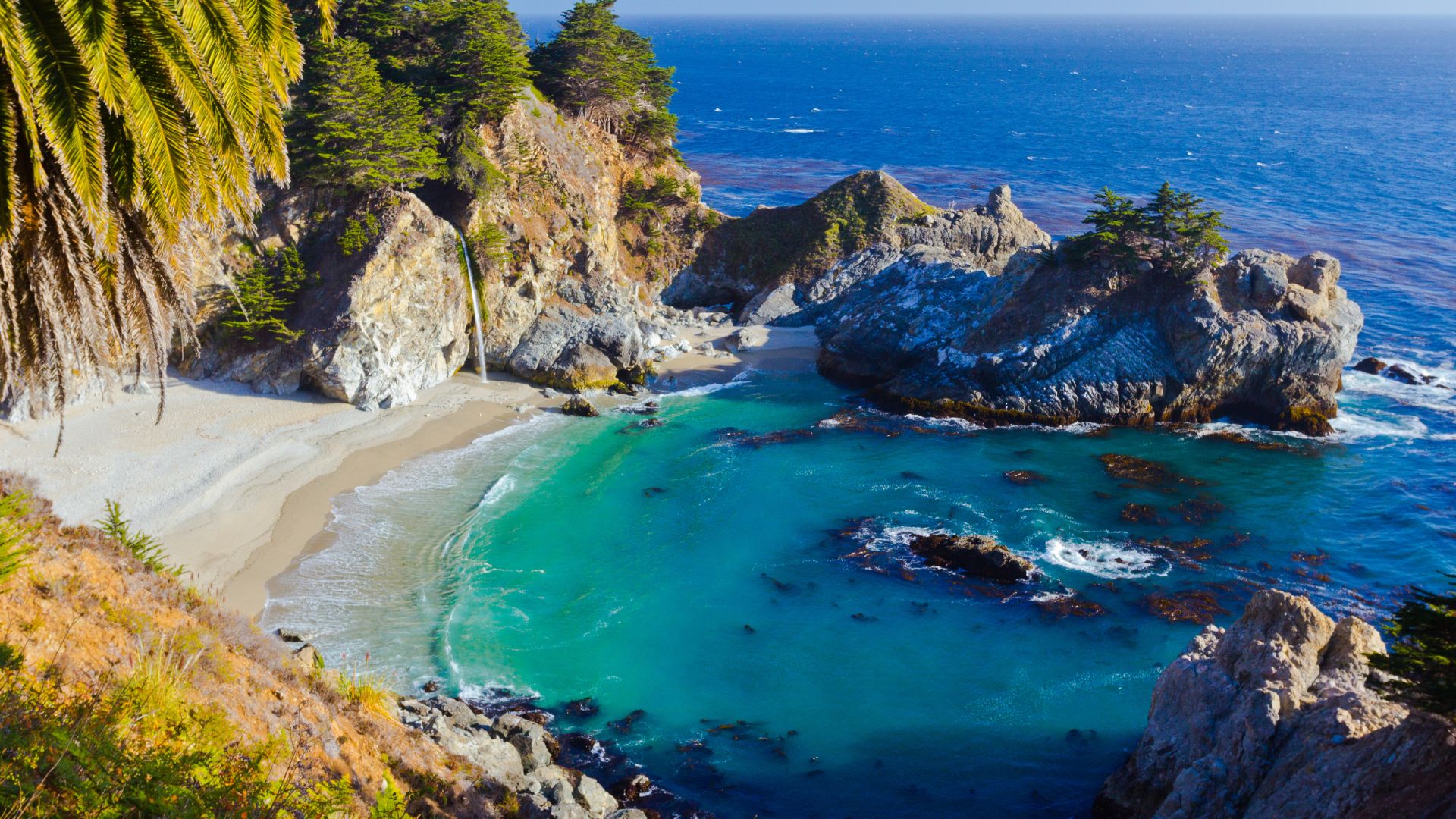
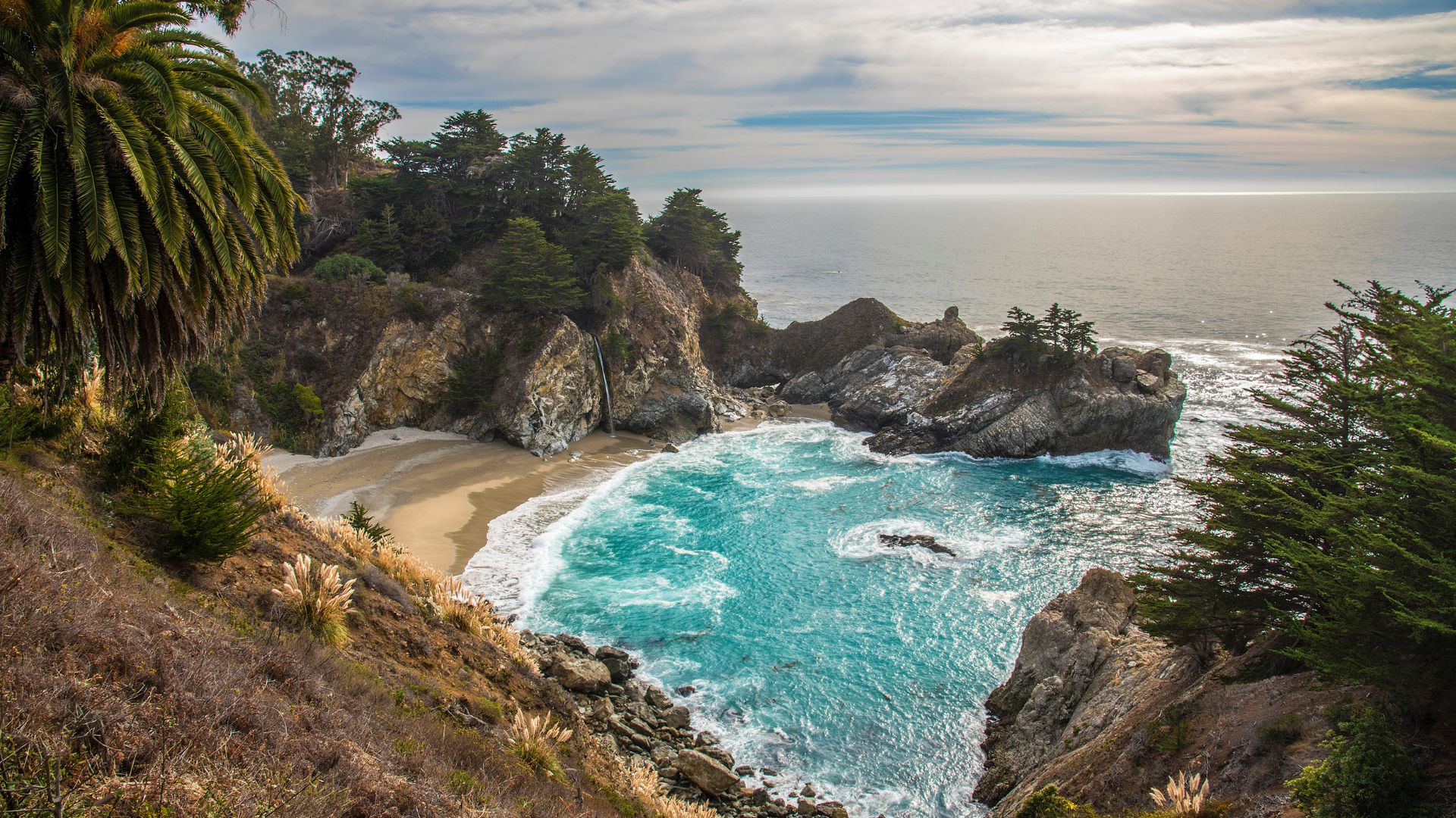
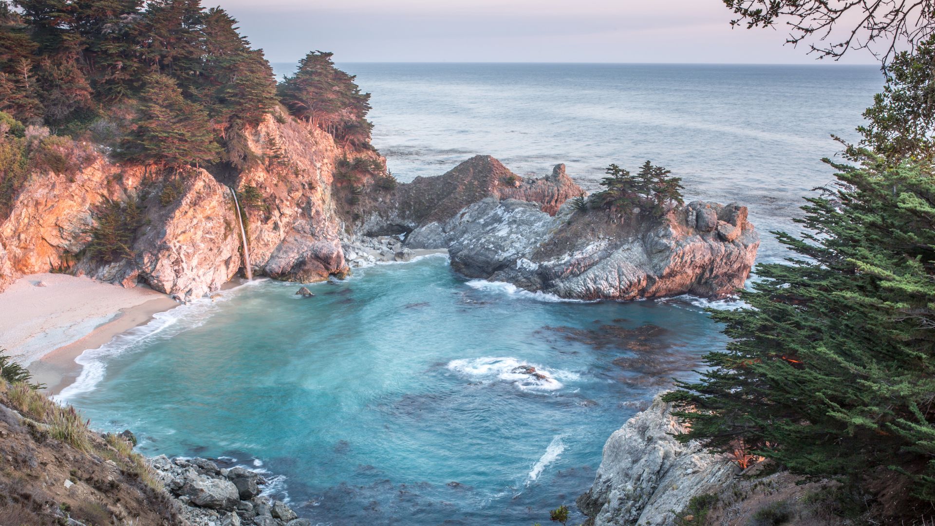
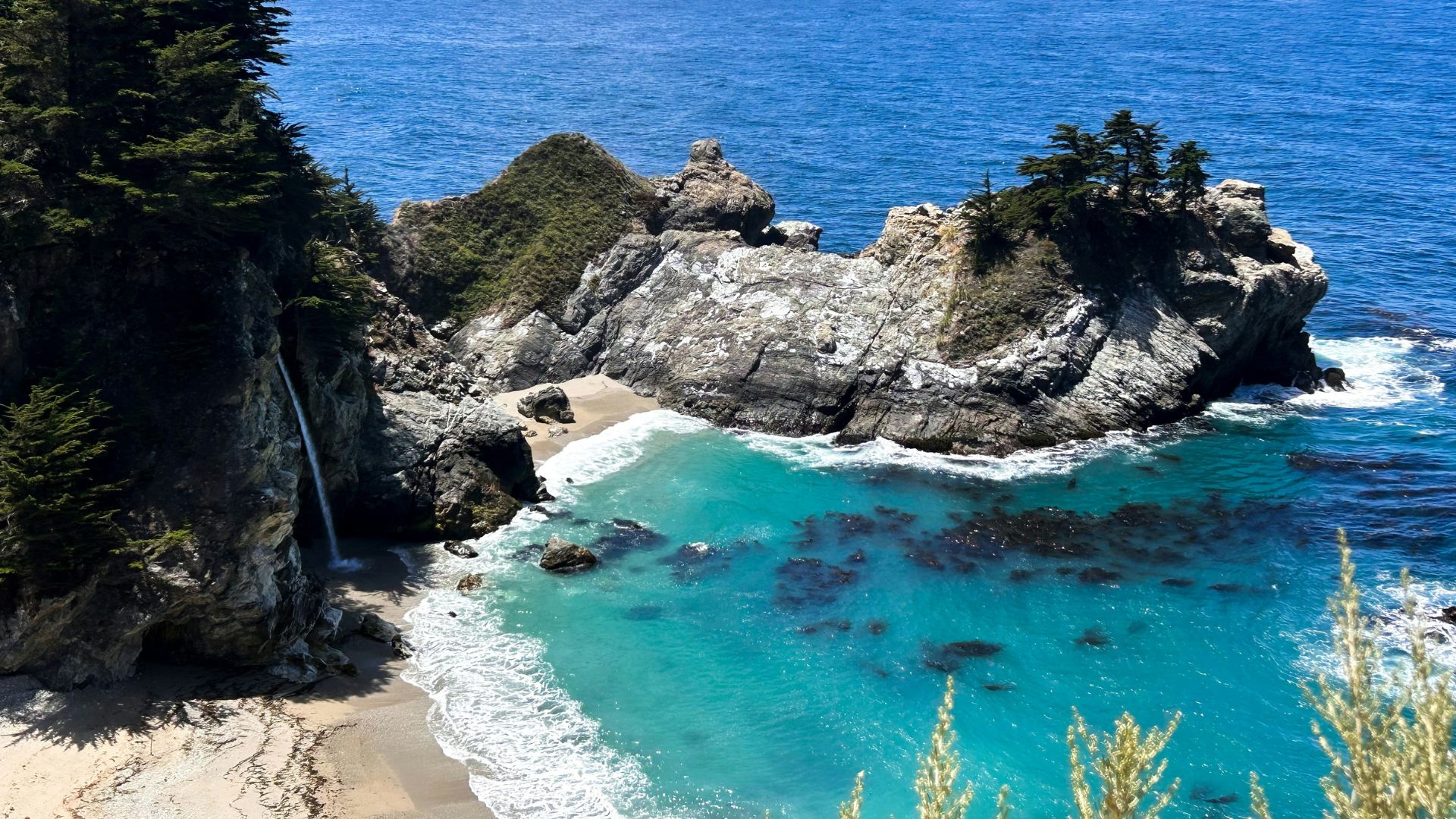
McWay Falls is one of those rare natural wonders that just stops you in your tracks. The first time I saw it, I remember thinking, “Is this real?” This 80-foot waterfall plunges right off dramatic granite cliffs and drops onto a pristine Big Sur beach—a scene that feels almost too perfect, but there it is, right along California’s wild coast.
What’s wild is that McWay Falls is one of only two named tidefalls in California. During high tide, the waterfall flows straight into the Pacific Ocean, which is honestly pretty mesmerizing.
I’ve chased a lot of waterfalls across California, but there’s something about McWay Falls that just sticks with you. Maybe it’s the way it sits within Julia Pfeiffer Burns State Park, about 37 miles south of Carmel on Highway 1.
The tides change everything here. Sometimes the water crashes right into the ocean waves, and other times it lands on the sandy beach below. The mood shifts with every visit.
When you come here, it’s not just about seeing a waterfall. You get to experience one of Big Sur’s most accessible and spectacular spots. There’s a short hike that opens up to jaw-dropping views of the rugged coastline.
The park is also a great launch point for exploring other hidden gems along this stretch of the Pacific Coast Highway. You might find something unexpected just around the bend.
The Magic of McWay Falls: A Tidefall Like No Other
You won’t find many places like McWay Falls. This is one of only two named tidefalls in California, with an 80-foot cascade that meets the Pacific Ocean head-on.
The waterfall’s spot on the cliff means the view changes depending on the tide. McWay Creek keeps the water flowing year-round, so there’s always something to see.
What Makes McWay Falls Unique
I’ve seen plenty of waterfalls, but McWay Falls really stands out. It’s rare because it’s a tidefall—during high tide, the water flows directly into the ocean.
The falls look different every hour. At high tide, the water drops straight into the Pacific. When the tide’s out, it lands on a tiny sandy beach in McWay Cove.
Key Features:
- Height: 80 feet
- Flow: Year-round
- Location: Julia Pfeiffer Burns State Park
- Beach Access: Not allowed
That beach below looks so tempting, but don’t even think about it—access is totally off-limits. It’s both dangerous and protected. You get the best views from the overlook trail above.
Scenic Views and Photography Tips
The overlook trail gives you some of the best views I’ve found anywhere along Big Sur. The walk is short—just half a mile—but you get a few different angles along the way.
Best Photography Times:
- Morning: Expect fog and a moody, mystical vibe
- Midday: Sunlight lights up the turquoise waters
- Evening: Golden hour is pure magic
Bring layers. The weather here flips in minutes, and fog can change your shots completely.
Crowds? Oh, yes. The overlook fills up fast, especially midday. I usually shoot for early morning or sunset—less people, better light. The viewing platform is small, so you’ll want a little patience if you’re hoping for that perfect photo spot.
The Role of McWay Creek and Tide Dynamics
McWay Creek starts way up in the Santa Lucia Mountains, about 1,270 feet up. It runs all year, so the falls never really dry up, even in the summer.
Tides make the show here. When the water’s high, the falls drop straight into the ocean. At low tide, you see the sandy cove below.
Tide Effects:
- High Tide: Water falls right into the ocean
- Low Tide: Lands on the sandy beach
- Extreme High Tide: The beach vanishes
The turquoise in McWay Cove? That comes from the creek’s fresh water mixing with the sea, giving the water that wild blue-green color.
Over time, the creek’s carried sediment down, slowly building the beach. Originally, the waterfall just dropped into the ocean, but now there’s a sandy cove thanks to years of erosion and even a landslide or two.
Exploring Julia Pfeiffer Burns State Park
Julia Pfeiffer Burns State Park is named after a true Big Sur pioneer—a woman who helped shape the region’s early days. The park protects diverse ecosystems, from coastal bluffs to redwood forests, with a big focus on conservation.
History and Significance of the Park
The park gets its name from Julia Pfeiffer Burns, a respected figure in early Big Sur history. She played a big role in the area’s development.
Land here stretches from the rugged coastline up to 3,000-foot ridges, packing a lot of habitats into a small space.
I love that the park still preserves buildings from the McWay and Pfeiffer Burns families. Walking past those old structures, you get a sense of how tough life was for early settlers out here.
McWay Creek has been flowing for over a century. Families like the McWays, Pfeiffers, and Partingtons settled this area and saw the falls take shape.
At first, McWay Falls dropped right into the ocean. After years of erosion—and a major landslide in 1983—the sandy beach we see today formed.
Wildlife and Natural Environment
Wildlife is everywhere here. I’ve watched sea otters playing in the surf and spotted California condors soaring overhead.
Bald eagles sometimes nest in the tall trees, and there’s even a rare blue butterfly colony tucked away in the park. These butterflies are a real treat since they’re found in so few places.
The park’s 300-foot redwoods create a cool, shaded world. These giants shelter all sorts of birds and small mammals.
Underwater, kelp forests sway with the current, building a whole other ecosystem below the surface. There are also underwater caves, but only experienced divers with permits should even think about exploring them.
Ocean conditions here turn on a dime. Strong tides and currents make diving risky—definitely not for beginners.

Visitor Rules and Conservation Efforts
The number one rule here? No beach access. Seriously, don’t try it. The beach looks inviting, but it’s dangerous and completely off-limits.
Stay away from the edge of the falls. The soil at the top is unstable, thanks to constant erosion.
If you break the rules, rangers will arrest you. I always remind folks: stick to the trails and the viewing areas.
There’s a $10 day-use fee per car, which goes toward keeping the park protected. You can grab a self-issued entrance pass at the gate.
Trail closures happen a lot here, usually after heavy rains cause mudslides or erosion. Always check conditions before you go—wildfires and storms can close the park without much warning.
Getting to McWay Falls: Access and Parking
McWay Falls sits right off Highway 1, about 37 miles south of Carmel and 12 miles south of Big Sur town. You’ve got two main parking options: pay to park inside Julia Pfeiffer Burns State Park, or try your luck with free roadside parking along the highway.
Driving the Pacific Coast Highway and Highway 1
Take it slow on the Pacific Coast Highway as you approach. The entrance to Julia Pfeiffer Burns State Park is clearly marked, but it’s still easy to miss if you’re distracted by the views.
Coming from the north, drive 37 miles south from Carmel on Highway 1. If you’re heading up from the south, it’s about 37 miles north from Ragged Point. The park entrance pops up on your right if you’re driving south.
If you’re on a Big Sur road trip, McWay Falls is a must-stop. It’s just 8.1 miles south of Nepenthe Restaurant, which is a handy landmark.
Keep an eye out for mile marker 36.2 on Highway 1. Even if the park’s closed, you can catch a glimpse of the falls from here.

Finding the Trailhead and Parking Options
You’ve basically got two ways to park:
Paid Parking (My Pick)
- Park inside Julia Pfeiffer Burns State Park
- $10 per vehicle for day use
- Safe tunnel under Highway 1 to reach the trail
- Restrooms available
- More reliable parking
Free Roadside Parking
- Park along the highway shoulder
- Spaces are limited and fill up fast
- More traffic risk
- No bathrooms or amenities
The trailhead starts on the west side of Highway 1. If you park in the state lot, walk through the tunnel beneath the road—no dodging traffic required.
Look for the Falls Trail sign just before the main entrance. The trail is pretty obvious and starts right after you come through the tunnel.
Accessibility Information
The trail to McWay Falls is mostly paved and pretty flat. I’d call it easy to moderate for most people. The round-trip distance is just 0.6 miles.
You’ll find some uneven spots near the viewpoint, so use caution if you have mobility challenges.
Trail Conditions:
- Mostly paved
- Gentle slopes
- Some rocky patches near the overlook
- Beach access isn’t allowed
The viewpoint has solid footing, but it can get crowded, which might make things trickier for some visitors.
No dogs or bikes on the trail. Rangers enforce this to help protect the park.
Hiking the McWay Falls Overlook Trail
Right now, the McWay Falls Overlook Trail is closed for a retaining wall project, and it won’t reopen until 2026. Usually, this short 0.5-mile round-trip trail is wheelchair accessible, with wooden boardwalks and paved paths for easy viewing of the 80-foot waterfall.
Trail Highlights and Route Details
The trail starts near the entrance kiosk at Julia Pfeiffer Burns State Park. You’ll need to grab a $10 day pass at the gate.
It’s a smooth, easy walk—wooden boardwalks, paved sections, and a tunnel under Highway 1. The trail heads north around McWay Cove.
Key Features:
- Distance: 0.5 miles round-trip
- Difficulty: Easy
- Accessibility: Wheelchair friendly
- Elevation: Minimal gain
The overlook sits where the Waterfall House once stood. Lathrop and Helen Hooper Brown owned the house, and they eventually donated their ranch to create the park.
From the platform, you get a perfect view of the falls dropping 80 feet onto the beach. That beach, by the way, only exists because of a 1983 landslide that reshaped the cove.
Best Times to Visit the Overlook
The trail’s closed until 2026, but when it’s open, timing matters.
Best times:
- Early morning: Fewer people, softer light
- Late afternoon: Golden hour for photos
- Winter: More water from seasonal rains
- Spring: Clearest water
Fog is a regular guest here, especially in summer afternoons. Always check the weather before you go.
Tide changes make a difference, too. High tide sends the waterfall straight into the ocean; low tide exposes the sandy cove.
Both views are stunning in their own way. McWay Falls is actually one of only eight U.S. waterfalls that flow directly into the ocean.
Safety Guidelines for Visitors
The overlook area has its hazards. The cliffs are unstable, and the surf below is unpredictable.
Safety basics:
- Stick to the trails and boardwalks
- Stay behind fences and barriers
- Don’t try to reach the beach below
- Keep an eye on kids near the edge
Crowds can make things hectic, so patience helps when you’re sharing the space.
Bring layers—the weather can swing from warm to chilly fast. The area gets windy, and temperatures shift throughout the day.
Emergency services aren’t close by, and cell service is spotty. Let someone know your plans before you head out.
The rocks below are no joke. Surf can change in seconds, and a few people have learned that the hard way.
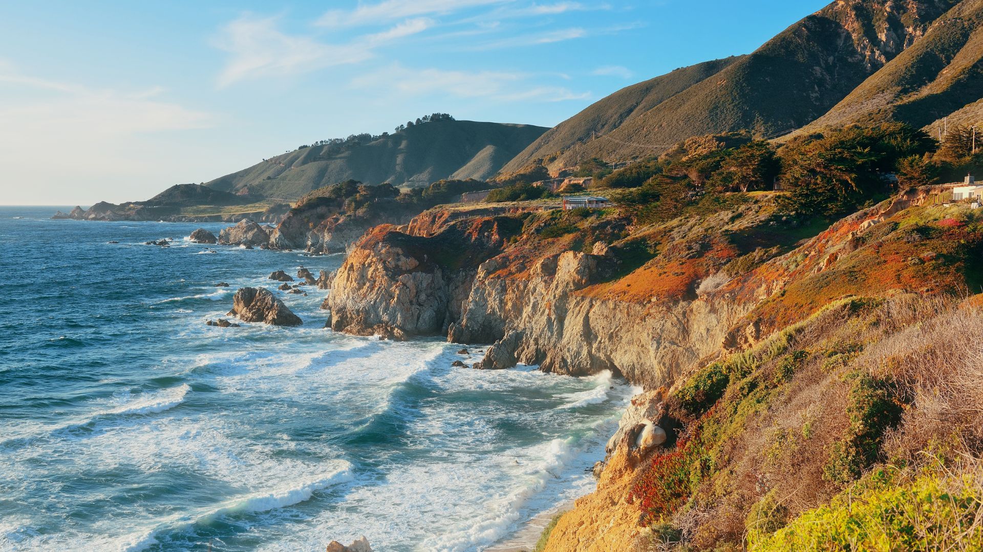
Nearby Attractions Along the Big Sur Coast
The Big Sur coastline is packed with unforgettable spots just minutes from McWay Falls. You can find hidden coves, stroll beneath towering redwoods, or treat yourself to world-class dining with an ocean view. There’s always something else to discover here.
Partington Cove and Other Local Trails
Partington Cove hides just north of McWay Falls, and honestly, it delivers a totally different vibe. If you want to escape the crowds and see something special, this spot is a must.
The trail’s about 1.5 miles, winding through thick redwoods before popping you out at a secret rocky beach. It’s steeper than the McWay Falls path, but most folks can handle it.
Limekiln State Park waits only 2 miles south of Julia Pfeiffer Burns State Park. This place stands out with four waterfalls and some old lime kilns from the 1800s. The main trail is a quick 1-mile trek that puts you right at Limekiln Falls.
The redwoods here? They’re giants—some shoot up over 300 feet. If you want to linger, the park has campsites tucked under the trees.
Famous Landmarks and Iconic Views
Bixby Creek Bridge stretches across Bixby Creek Canyon, about 15 miles north of McWay Falls. This concrete arch bridge is seriously photogenic—maybe you’ve seen it in car commercials or postcards.
You’ll get your best shots from the pullouts on either end. I always stop at the northern viewpoint for that classic view everyone loves.
Point Lobos sits about 30 miles north, near Carmel. It protects more than 1,200 acres of rugged coastline and marine life. Short trails snake out to wild cliffs, and the views can be jaw-dropping.
Sea lions love to hang out at Point Lobos, especially along the Cypress Point Trail. If you visit, just know there’s a $10 entrance fee per car.

Dining and Amenities Nearby
Nepenthe Restaurant probably wins the prize for most iconic meal in Big Sur. Perched 800 feet above the ocean and just 3 miles north of McWay Falls, the views are almost as good as the food.
They serve California-inspired dishes, heavy on local seafood and fresh flavors. The Ambrosia burger? It’s been a favorite since 1949. You’ll want a reservation for dinner, trust me.
Deetjen’s Big Sur Inn offers rustic rooms about 5 miles south of the falls. The inn’s restaurant serves up cozy breakfasts and hearty dinners. There aren’t any TVs or phones in the cabins, which honestly adds to the charm.
Gas stations are few and far between along this stretch of Highway 1. I always make a point to fill up in Big Sur Village or Lucia before heading out.
Other Notable Waterfalls and Destinations
Big Sur hides more waterfalls than most people realize. Canyon Falls offers a wilder trek up McWay Creek, while Pfeiffer Falls gives you a mellow hike through redwoods to a 60-foot drop.
Canyon Falls and McWay Creek Exploration
Canyon Falls sits upstream along McWay Creek in the Santa Lucia Mountains. You’ll have to work a bit harder to reach this one—it’s a tougher hike than the more famous falls below.
The trail hugs McWay Creek and winds through thick forest. Honestly, the path gets rough in places, and I found myself scrambling over roots and rocks.
Key Details:
- Distance: 2-3 miles roundtrip
- Difficulty: Moderate to challenging
- Best Time: Winter and spring, when the water really roars
The creek itself carves out bright pools and tumbles over small cascades. Most people skip this part, focusing just on McWay Falls, but that’s their loss.
If you go, bring sturdy boots and more water than you think you’ll need. Those creek crossings can get slick, especially after rain.
Exploring Pfeiffer Falls and Lesser-Known Sights
Pfeiffer Falls rises 60 feet inside the beautiful Pfeiffer Big Sur State Park. If you’re looking for an easier hike than Canyon Falls but still want a jaw-dropping view, this spot really delivers.
The trail to the falls is just 1.5 miles roundtrip, winding through those iconic, towering redwoods. When I walked it, I noticed how manageable it felt—even for families with younger kids or anyone who isn’t a hardcore hiker.
Trail Features:
- Wooden bridges that cross gentle streams
- Signs with fun facts about the local plants
- A shady, peaceful path beneath old-growth trees
You’ll find the waterfall running all year, but it’s at its most dramatic in winter. Honestly though, I think spring is the sweet spot—you get plenty of water, and the weather’s just right for hiking.
One thing I love here: you can actually get close to Pfeiffer Falls. Unlike McWay Falls, you’re only about 50 feet from the thundering water at the viewing area.
If you have time, try to see both waterfalls on your Big Sur adventure. It’s totally worth it.