Point Lobos State Natural Reserve is, hands down, one of California’s most jaw-dropping coastal spots. Picture dramatic cliffs, sparkling blue water, and wildlife everywhere you look. I’ve wandered a lot of trails up and down the California coast, but honestly, Point Lobos near Monterey just keeps calling me back with its breathtaking ocean views.
These three hikes I’m sharing are perfect for everyone—whether you’re a total newbie or you’ve got a closet full of hiking boots. Each one offers up those panoramic Pacific views you’re probably craving.
Some of these trails are quick 15-minute strolls, while others stretch out along the coast for a bit more adventure. No matter your pace or experience, you’ll find something magical here without feeling like you’ve bitten off more than you can chew.
What makes these hikes stand out? Each one highlights a different side of Point Lobos—sea lions barking on the rocks, hidden turquoise coves, ancient cypress groves, and those wild rock formations. I picked these trails because they’re easy to access, packed with scenery, and each has a unique vibe that shows off why Point Lobos is so special.
Why Point Lobos Is the Ultimate Hiking Destination for Ocean Views
If you’re after dramatic coastal scenery, Point Lobos delivers big time. Over six miles of trails wind past rugged cliffs, quiet coves, and a ton of marine wildlife.
The place is just stunning, but what I really love is that the trails work for everyone—no need to be a hardcore hiker to enjoy the best parts.
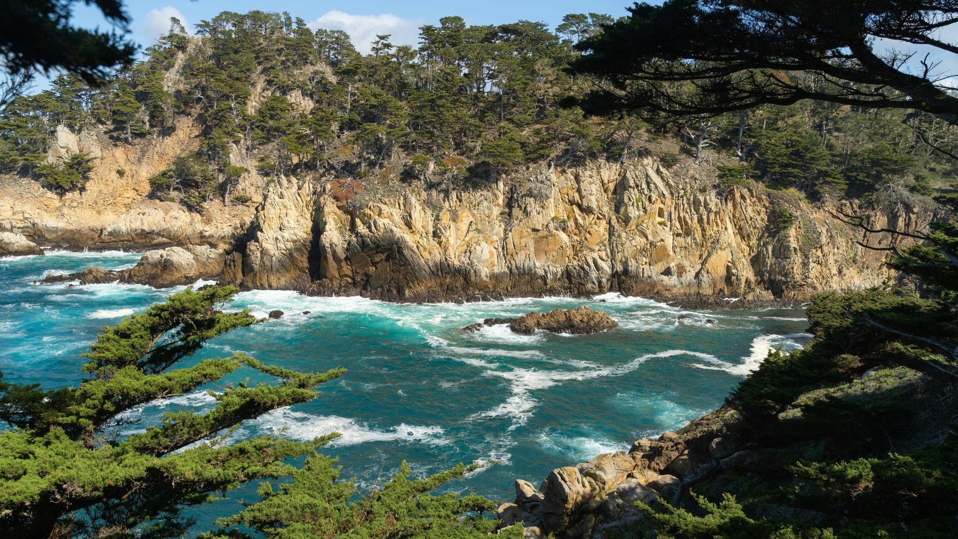
Spectacular Coastal Landscapes and Hidden Coves
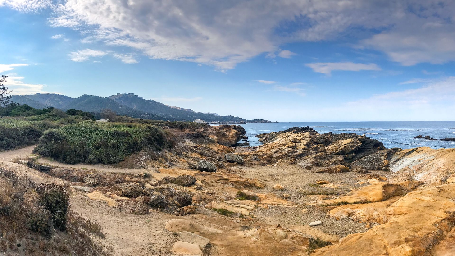
Out of all the ocean views I’ve seen along the California coast, Point Lobos tops the list. The reserve covers 1,200 acres of coastal land, with cliffs that plunge straight into the Pacific.
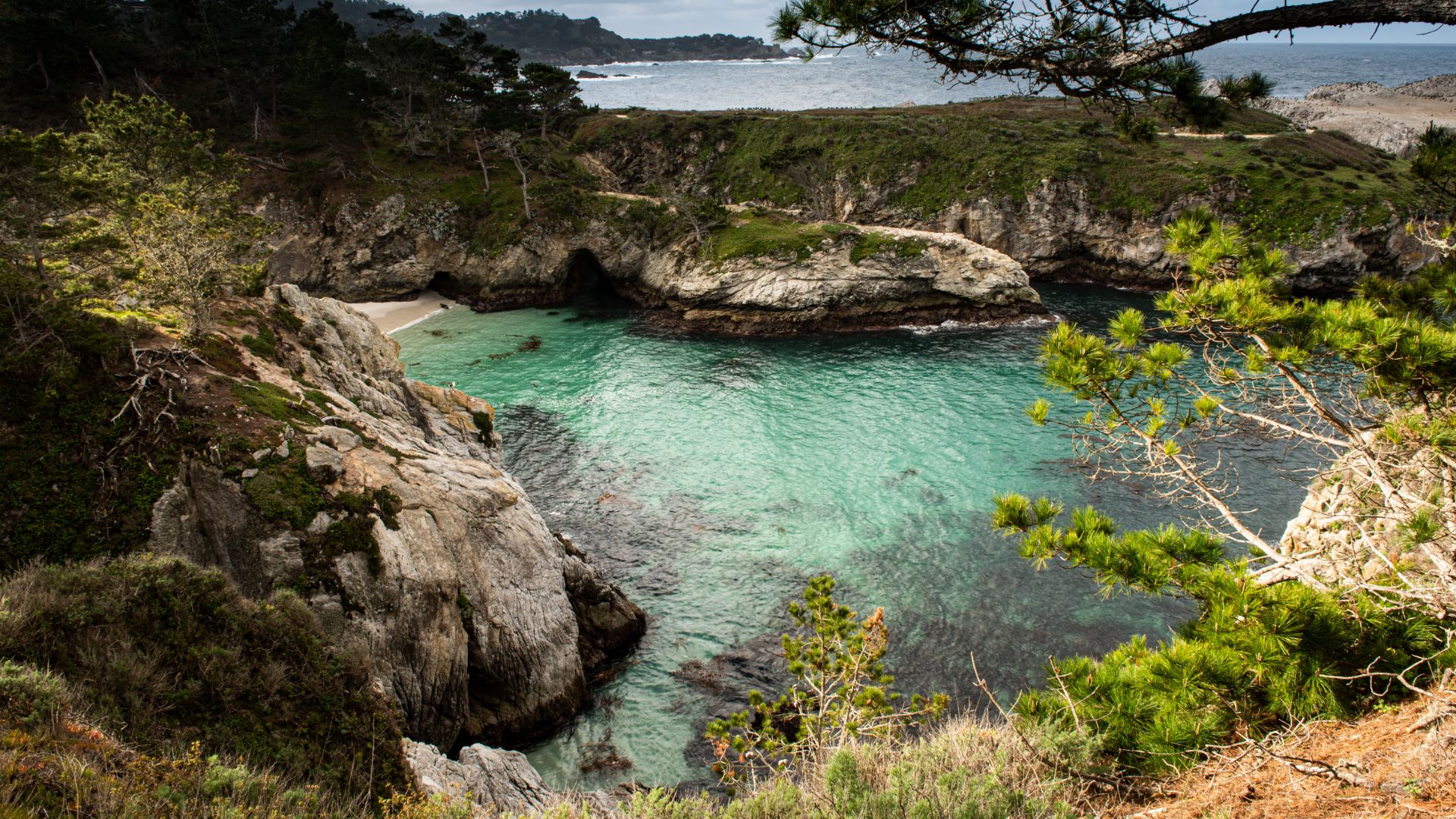
Every trail reveals something a little different. China Cove’s clear turquoise water and granite cliffs look almost unreal. Gibson Beach is tucked away and perfect for watching harbor seals.
The coastline’s full of wild rock formations—Bird Island and Coal Chute Point are just a couple. They make the best backdrops for photos or just sitting and watching the waves.
Some of my favorite viewpoints:
- Cypress Cove, where ancient Monterey cypress trees twist in the wind
- Headland Cove, with those sweeping ocean panoramas
- Big Dome Cove’s dramatic rocks
- Granite Point’s wide-open Pacific views
Since Point Lobos sits inside the Monterey Bay National Marine Sanctuary, the water stays super clear. That means you get those killer ocean views and a chance to spot what’s swimming below.

Rich Wildlife: Sea Lions, Otters, and Seabirds
Spanish settlers named this spot “Punta de Lobos”—Point of the Sea Wolves—because of all the California sea lions barking at Sea Lion Point.
I usually spot sea otters floating on their backs in the kelp beds. They’re always busy cracking open sea urchins or abalone with rocks.
Harbor seals love to hang out on the beaches, especially at China Cove and Gibson Beach. If you’re around in April or May, you might catch a glimpse of the pups during pupping season.
Wildlife I often see here:
- Sea lions—always around Sea Lion Point
- Sea otters—look for them from Cypress Grove Trail
- Harbor seals—especially at China Cove and Gibson Beach
- Gray whales—migrating December-January and March-May
- Seabirds—pelicans, cormorants, gulls, you name it
Bring binoculars if you can. Watching the animals from a respectful distance is half the fun, and you’ll want to snap some photos too.
Accessibility and Trails for All Fitness Levels
Point Lobos really does a great job making trails for everyone. You’ll find everything from flat, easy walks to moderately challenging hikes. Multiple parking lots make it easy to start wherever you want.
Cypress Grove Trail is a super easy 0.9-mile stroll through one of California’s only native Monterey cypress groves. You’ll get awesome ocean views with hardly any uphill.
If you want the full experience, try the Point Lobos Loop. It links several trails into a 6.5-mile adventure with about 650 feet of elevation gain. Most folks finish it in 3-4 hours, but you can always turn back sooner.
Trail difficulty at a glance:
- Easy: Cypress Grove Trail, Sea Lion Point Trail
- Easy-Moderate: Bird Island Trail, South Shore Trail
- Moderate: Full Point Lobos Loop
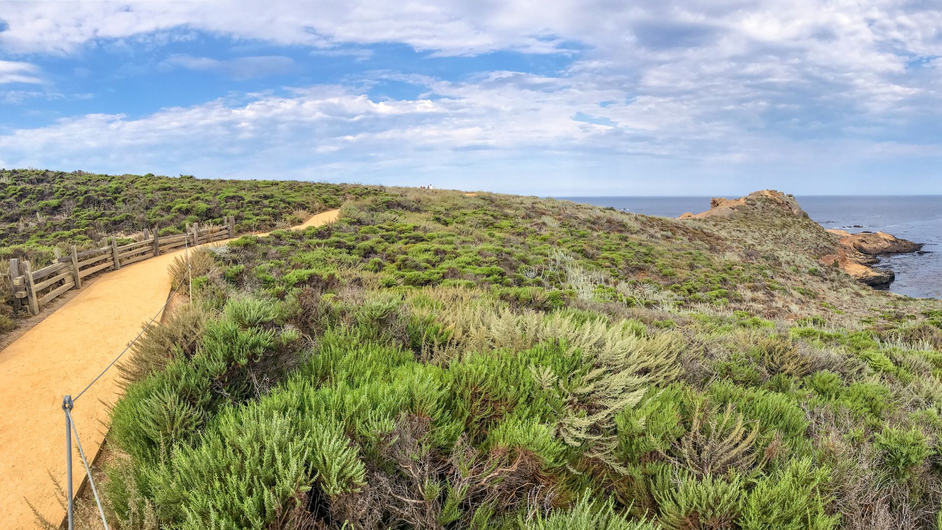
The paths are well-kept with plenty of signs and info boards. Some overlooks have boardwalks and platforms, so even visitors with mobility challenges can enjoy the views.
Restrooms and water fountains pop up throughout the reserve, so you don’t have to worry about roughing it. Since it’s a day-use park, you’ll usually avoid the big crowds you find at campgrounds.

Essential Tips for Hiking in Point Lobos
A little planning goes a long way here. Parking fills up fast, especially on weekends. I always try to get there early for the best spots and the best chance to see wildlife.
Bring layers—coastal weather can flip from sunny to chilly in no time. And please, stick to the marked trails. It keeps you safe and protects the reserve.
How to Get There and Parking Insights
Point Lobos sits just south of Carmel-by-the-Sea, right off Highway 1. It’s only about four miles from town, and the drive from Monterey takes maybe 20 minutes.
Parking’s a challenge if you show up late. I always aim to arrive by 9 AM, especially on weekends or holidays. They limit the number of cars to help protect the environment.
Parking lots to know:
- Bird Island Trail lot (this one fills up first)
- Sea Lion Point lot
- Whaler’s Museum area
If all the lots are full, you’ll have to wait or come back later. No reservations for day use, so it’s first come, first served.
Weekdays are quieter, and in winter you might score a spot even after 10 AM.
Best Time to Hike for Prime Views and Wildlife
Early mornings, between 8 and 11 AM, are my favorite for catching wildlife and getting those clear ocean views. Sea otters seem busiest then.
Seasonal tips:
- Spring (March-May): Wildflowers everywhere, mild temps
- Summer (June-August): Mornings can be foggy, afternoons usually clear up
- Fall (September-November): Best weather, plus whale migration
- Winter (December-February): Fewer crowds, stormy waves
Sunsets are fantastic for photos, but remember—they close the gate at 6:30 PM, so get in early.
For tidepooling, Weston Beach at low tide is a must. Check the tide charts before you go.
What to Bring and Trail Etiquette
Here’s what I never leave behind:
- Layers (the weather’s unpredictable)
- Good walking shoes with grip
- Water bottle
- Camera or phone for photos
- Binoculars (trust me, you’ll use them)
Trail etiquette matters:
- Only walk on marked trails
- Don’t mess with wildlife or sea life
- Pack out your trash
- Keep it quiet near animal areas
- No dogs—sorry, pups have to stay home
Watch out for poison oak—it grows everywhere out here.
These trails are better for wandering and sightseeing than for running. And if you’re hoping to scuba dive, you’ll need a special permit and can’t do it in most areas.
Sea Lion Point Trail: The Iconic Short Walk to Panoramic Ocean Views
Sea Lion Point Trail is a classic—a 0.6-mile loop that’s easy, accessible, and loaded with wildlife encounters. You’ll link up with Sand Hill Trail and get multiple chances to spot sea lions, harbor seals, and otters doing their thing.
Trail Overview and Highlights
Start at the west side of the Sea Lion Point parking lot, under those towering cypress trees. I usually take the right fork to get straight to the ocean views.
It’s an easy trail—about 30 minutes, with just 26 feet of elevation gain. If you stick to the upper part and loop with Sand Hill Trail, it’s fully accessible.
Quick details:
- Distance: 0.6 miles round trip
- Difficulty: Easy
- Time: 30-60 minutes
- Accessibility: Upper trail is wheelchair-friendly
You’ll wander through coastal gardens filled with native plants. In spring and summer, wildflowers pop up in a rainbow of colors.
A few broad steps lead down to lower viewing areas with new angles on the coves. The lower trail has a steep staircase to a pebbly beach, but sometimes they close it during winter storms.
Best Wildlife Spotting Locations
Headland Cove is where I usually see otters floating in the kelp. Harbor seals like to sun themselves on the rocks at the water’s edge.
Sea Lion Cove is the spot for watching harbor seals just below the main viewpoint. Sometimes, you’ll find docents with spotting scopes here—they’re happy to help you spot animals up close.
You’ll hear California sea lions barking from offshore rocks. That stretch between Sea Lion Point and Sea Lion Rocks (called Devil’s Cauldron) really shows off the ocean’s power.
Wildlife spotting tips:
- Go early or late for the most animal activity
- Binoculars help for seeing sea lions farther out
- Watch for ground squirrels and sparrows along the path
- Stay back from cliff edges—it’s steeper than it looks
Connecting Trails: Sand Hill and Lace Lichen
You can easily link Sea Lion Point Trail with Sand Hill Trail for a longer loop. Both are flat and keep those ocean views coming, plus the route’s fully accessible.
Sand Hill Trail gives you new perspectives on both Headland Cove and Sea Lion Cove. If you’re feeling adventurous, Lace Lichen Trail branches off here, but it’s a little tougher.
Try the Sea Lion Point loop first, then decide if you want to add on. It’s nice to have options—stick to the 0.6-mile loop or keep exploring along the coast.
Bird Island Trail: A Scenic Route to China Cove and Gibson Beach
Bird Island Trail is one of the best short hikes at Point Lobos. You get those jade-green waters at China Cove, easy wildlife viewing at Bird Island overlook, and a 0.8-mile round trip that’s doable for almost everyone. Plus, it’s a birdwatcher’s dream year-round.
Trail Highlights and What to Expect
Bird Island Trail starts at the southernmost parking lot. It’s an easy, mostly flat 0.8-mile loop, with only the beach access points being a bit tricky.
You’ll move through three different habitats—Monterey pine forest, coastal scrub, and rocky shores with ocean views the whole way.
Trail basics:
- Distance: 0.8 miles round trip
- Difficulty: Easy to moderate
- Elevation gain: Minimal
- Accessibility: Fully accessible except for beach stairs
The path weaves between pine woods and the sea, passing two white sand beaches before ending at the Bird Island overlook.
There are picnic tables and restrooms at the trailhead. If you forgot binoculars, you can borrow some from the info station at Sea Lion Point parking lot.
Birdwatching and Spectacular Wildflowers
Spring and summer turn Bird Island into a bustling seabird colony. I’ve seen hundreds of Brandt’s cormorants nesting shoulder to shoulder on the rocks.
Western gulls nest here too, with fluffy chicks peeking out in season. Black-crowned night herons also nest on Bird Island, but they’re a little shy and harder to spot.
Birds to watch for:
- Brandt’s cormorants (tons during nesting)
- Western gulls and chicks
- Black-crowned night herons
- Great blue herons (often down by the water)
In spring, wildflowers line the trail to Pelican Point. The color is unreal between March and May—perfect for snapping a few photos.
Sometimes I spot great blue herons perched on driftwood, waiting for fish. Between the seabirds above and wading birds below, it’s an awesome spot for bird photography.
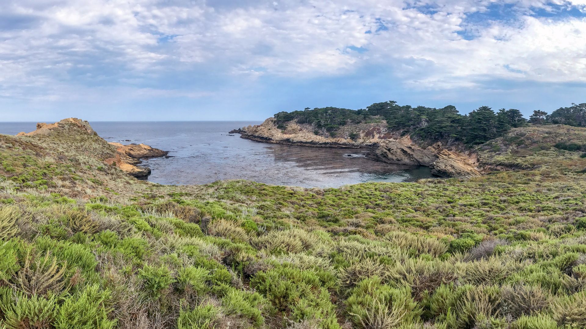
Exploring China Cove, Gibson Beach, and Bird Island Overlook
China Cove is straight-up stunning—jade-green water and a tiny white sand beach tucked into a protected cove.
In spring, harbor seals use China Cove as a nursery. I always watch from the trail above to give the moms and pups some space. The view from up there is hard to beat.
Gibson Beach is about 0.2 miles from the trailhead and has a staircase down to the sand. It’s a longer beach, great for walking or checking out tide pools.
At Pelican Point, the Bird Island overlook gives you the best wildlife viewing. You can see the whole seabird colony and, if you’re lucky, spot sea otters diving in the kelp below.
Things to look out for:
- Harbor seals lounging on rocks
- Sea otters floating in the kelp
- Natural arches and erosion features
- Wild rock formations shaped by the waves
From the overlook, you can see how the ocean’s carved out Bird Island from collapsed sea arches. Nature’s always working here, and it’s honestly a little humbling to watch.

South Shore Trail: Stunning Coastal Views for Every Hiker
If you’re craving an easy walk with jaw-dropping ocean vistas, the South Shore Trail is a gem. The path hugs Point Lobos’ wild coastline, leading straight to hidden beaches and tide pools that honestly blew me away. At just 2.5 miles out-and-back, it’s a breeze for most hikers and delivers some of the best tide pooling I’ve found on the Central Coast.
Pathway Overview and Terrain
You’ll find the South Shore Trail starting up near the main parking lot, where a wide dirt path runs parallel to the southern cliffs. I love how accessible this trail feels—there’s barely any elevation, so you can just focus on the views.
The ground stays pretty firm, even after a bit of rain, and the path is scattered with small rocks. It’s wide enough for a relaxed walk, and you won’t have to worry about squeezing past other hikers.
Trail Stats:
- Distance: 2.5 miles out-and-back
- Elevation Gain: Under 100 feet
- Difficulty: Easy
- Time: 1.5-2 hours
Coastal scrub lines the way, and the ocean never really leaves your side. I always end up snapping way too many photos—each bend reveals something new.
You’ll wind past tucked-away coves and dramatic rocky outcrops. Wooden signs pop up at the right moments, so you won’t get lost.
Weston Beach and Tide Pool Discoveries
Weston Beach sits at the far end of the trail, and honestly, it’s the main reason I come out here. Tucked into a sheltered cove, the beach is small and sandy, but the real draw is the tide pools.
I’ve spent ages poking around these rocks at low tide. Sea stars, hermit crabs, sea anemones—they’re all here if you know where to look.
Best Tide Pool Viewing:
- Morning low tides (always check the tide charts)
- Spring months for extra marine activity
- Calm weather for crystal-clear water
The rocky shelves stretch right into the surf, creating little worlds for all sorts of creatures. I make a habit of checking tide times before heading out—no sense arriving when the pools are underwater.
You’ll spot purple sea urchins and green sea anemones everywhere. Tiny crabs dart for cover as soon as you get close.
Just a quick note: look, don’t touch. Everything here is protected, and these tide pools are delicate.
Planning the Ultimate Point Lobos Hiking Day
If you want to get the most out of Point Lobos, try mixing a few trails together for a solid loop. I like to arrive early—parking fills up fast, and you’ll want time to wander the trails and explore Whalers Cove.
How to Combine the Top Trails into a Memorable Loop
I usually piece together a Point Lobos loop that links up all the best trails. My go-to route starts at the Bird Island Trail parking lot.
First up is the Bird Island Trail (0.8 miles), which is short but full of views. From there, I hop onto the South Shore Trail (2 miles) heading north, so I don’t miss out on Weston Beach and those tide pools.
After that, I connect to the Sea Lion Point Trail (0.6 miles) using the nearby junctions. This keeps you right along the coastline, moving naturally from south to north.
For a longer adventure, I tack on the Cypress Grove Trail (0.8 miles) to see those rare Monterey cypresses. Wrapping up with the North Shore Trail (2 miles) brings you back toward the east side.
Total distance: 6-7 miles, depending on how you connect the trails
Total time: 4-6 hours, especially if you linger at the best spots
Difficulty: Easy to moderate
This combo covers all the highlights without forcing you to double back. I always grab a park map—some of the connectors aren’t obvious, and it’s easy to get turned around.

Notable Stops: Whalers Cove and Whalers Cabin Museum
Don’t skip Whalers Cove—it’s a must-see for both the scenery and the history. Every time I visit, I make a point to stop here.
The Whalers Cabin Museum sits right by the water and is packed with stories from the area’s whaling past. Inside, you’ll find artifacts from the 1850s, when both Chinese and Portuguese whalers worked these shores.
Museum highlights include:
- Original whaling gear and tools
- Vintage photos of whaling crews
- Native American artifacts found nearby
- Interactive displays about ocean life
The museum usually opens from 10 AM to 4 PM, but the hours can shift with the seasons. It’s a great spot to take a break—picnic tables overlook the cove, so you can snack with a view.
Whalers Cove itself feels peaceful and wild at the same time. I often spot harbor seals or a sea otter floating in the calm, blue-green water. If you’re into diving, this is one of California’s top underwater spots—visibility is often fantastic.
Nearby Attractions in Carmel and Monterey
Carmel-by-the-Sea sits just 10 minutes north of Point Lobos. It’s honestly the perfect spot to stretch out a day trip. After a morning hike, I usually wander into one of Carmel’s cozy restaurants for lunch—there’s always something that hits the spot.
Top Carmel stops include:
- Carmel Beach – Wide, sandy, and framed by those dramatic cypress trees. I love just walking along the shore, shoes in hand.
- Carmel Mission – This historic Spanish mission, built in 1771, has peaceful gardens that invite you to linger.
- Fairy Tale Cottages – The downtown area feels like a storybook come to life, with quirky architecture around every corner.
Monterey lies about 20 minutes farther north and has a totally different vibe. The Monterey Bay Aquarium always impresses me—it’s packed with the same marine life you’ll spot out at Point Lobos, but up close.
You can drive the iconic 17-Mile Drive to connect Point Lobos with both Carmel and Monterey. Honestly, I never get tired of the ocean views along this route. Pebble Beach’s famous golf courses and those wind-bent Monterey cypress trees are worth a detour.
If you’re wondering about timing, here’s what I usually do: hit Point Lobos in the morning (parking is so much easier), grab lunch in Carmel, then roll up to Monterey for the afternoon. It’s a great way to see the best of the coast without feeling rushed.
Thinking about staying longer? Both towns have plenty of hotels. Turning your Point Lobos adventure into a weekend getaway is never a bad idea.