Southern California bursts with dramatic coastlines, rolling mountains, and sun-baked deserts. Sure, the Pacific Coast Highway gets all the hype, but I’ve uncovered a handful of other drives that really show off the region’s wild side. Here are my top 5 most scenic drives in Southern California—each one brings something special, way beyond the famous PCH.
On these roads, I’ve cruised under open skies dotted with Joshua trees and wound my way up hilltop highways with sweeping views of LA. I stumbled on spots perfect for quick breaks, snapshots, or just soaking in the peace—plus, these routes usually dodge the big crowds.
Maybe you’re plotting a full-on road trip, or maybe you just want a chill day with a view. Either way, these drives serve up a different slice of SoCal. Each one has its own vibe, history, and a few hidden gems that made my adventures stick in my memory.
Criteria for the Most Scenic Drives in Southern California
When I picked these drives, I wanted routes that really stood out for their natural beauty and breathtaking views. I looked for variety—ocean cliffs, forests, desert stretches, you name it.
Selection Process
I didn’t just rely on guidebooks. I spent time reading traveler reviews, chatting with locals, and then hitting the road myself. Experiencing each drive firsthand made it easier to compare what really stood out and which roads felt safe and fun to drive.
I wanted each drive to feel different, so I skipped anything that felt too much like PCH. I paid attention to the unique features—mountain passes, wildflower fields, or those jaw-dropping coastlines. The goal? To capture what makes SoCal’s landscape so darn special.
Highlights of Unique Landscapes
Southern California’s scenery is nothing if not diverse. Every route I picked has at least one “wow” moment. Some twist high above the ocean, while others cut through thick forests or wind between boulders in the desert.
I found mountain views in Angeles National Forest that honestly surprised me, and Malibu’s coastline left me speechless more than once. I even added a drive through Joshua Tree—because where else do you get that mix of rocky desert and endless sky? I love when the road and the view play off each other for that perfect driving experience.
Seasonal Considerations
Timing can make or break a scenic drive. In spring, wildflowers exploded along the roads, especially in the mountains and valleys. Coastal drives shined brightest in late spring and early summer, when the sky’s clear and the ocean sparkles.
Inland routes? I learned to start early or wait for late afternoon—summer heat out there is no joke. I always checked for road closures from rain, fires, or even snow up high. Picking the right season made each drive safer and way more beautiful.
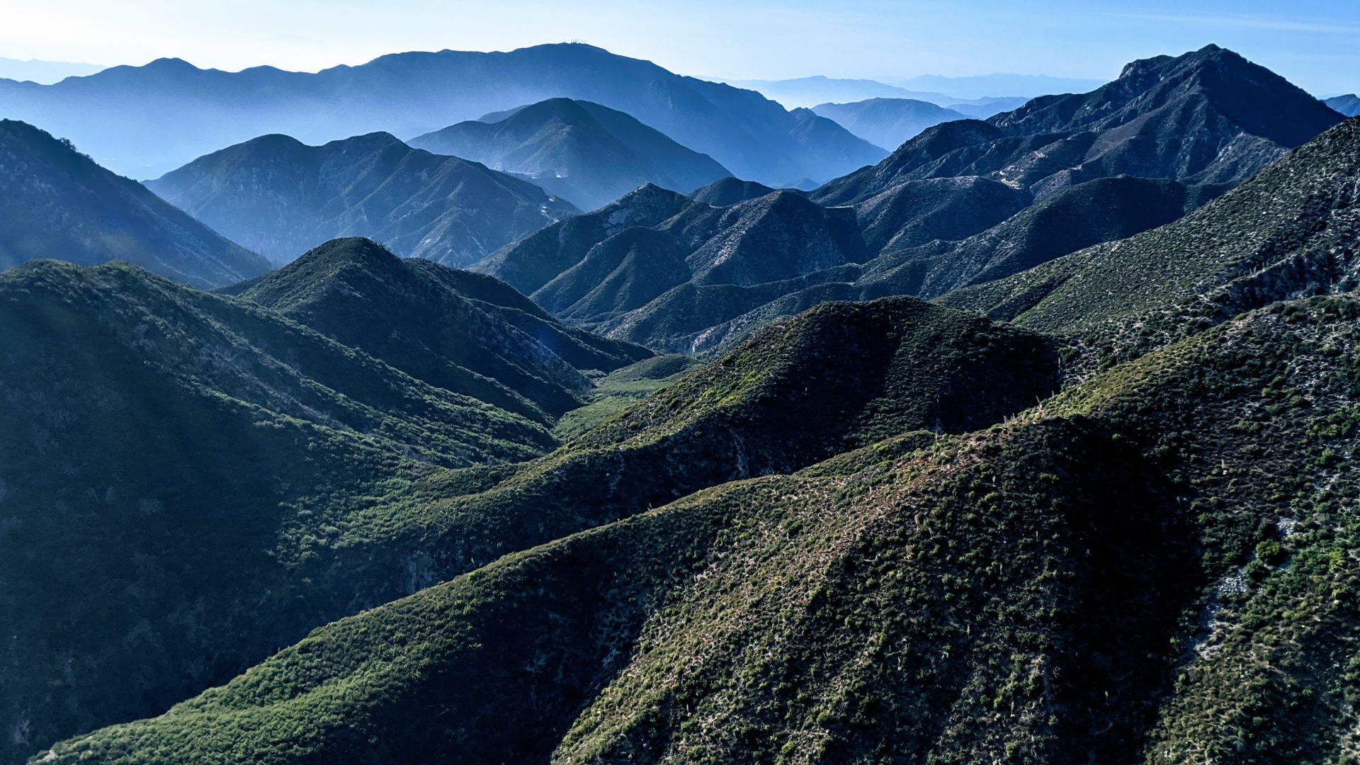
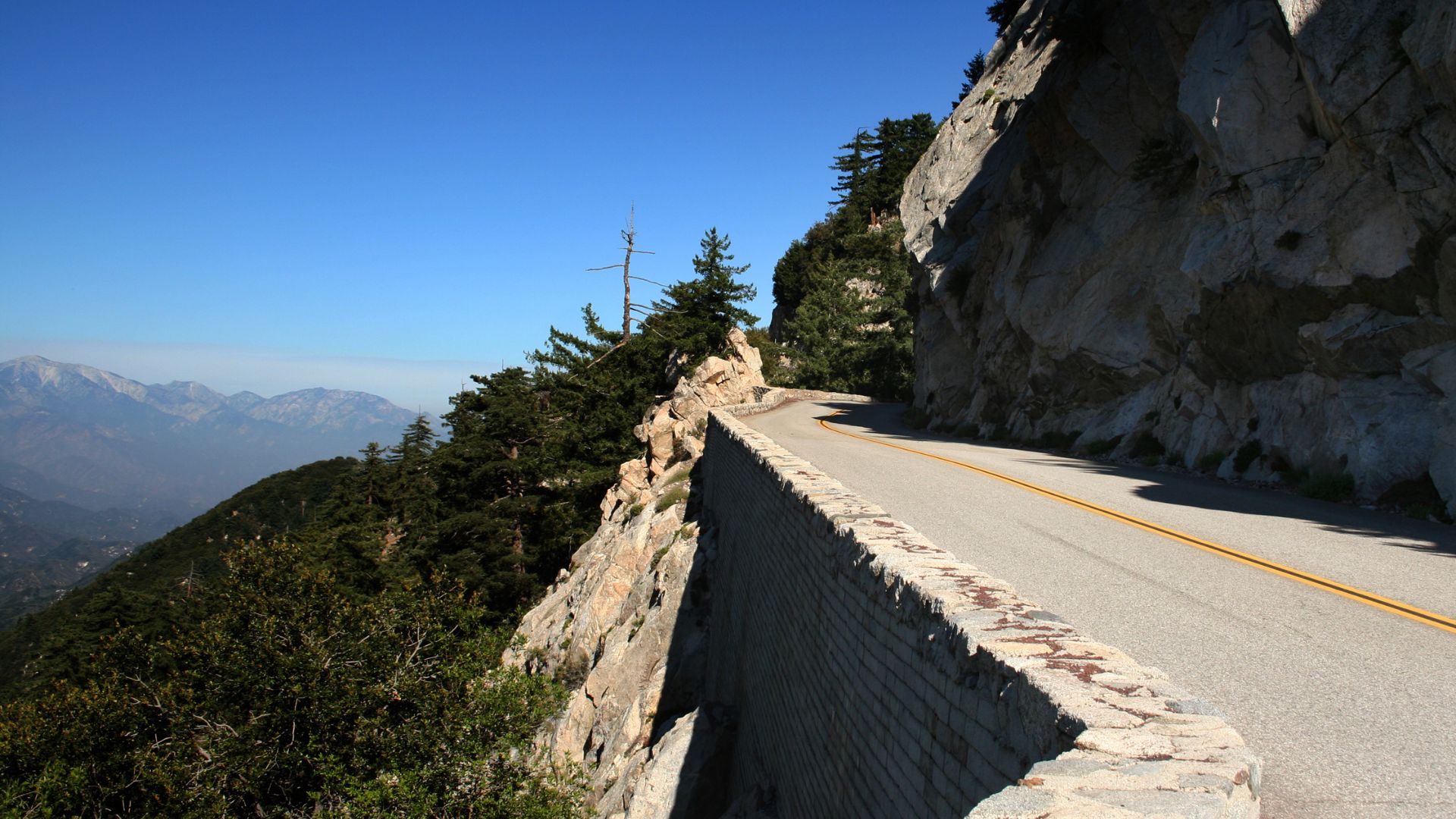
Angeles Crest Highway: Gateway to Alpine Beauty
Angeles Crest Highway sweeps you up from the edge of LA into the cool, high-altitude world of the San Gabriel Mountains. Suddenly, you’re passing forested ridges and quiet valleys that feel miles from city life.
Best Stops and Viewpoints
I found a bunch of great stops here. Dawson Saddle sits over 7,900 feet up and gives you a real sense of the mountain’s scale. Inspiration Point? The name says it all—wide views of the whole range. Most viewpoints have signs, and each one shows off a different side of the Angeles National Forest.
Pulling over, I’d see pine-covered ridges, twisty roads, and sometimes LA itself on a clear day. Red Box Junction became my go-to for a shaded picnic or just a breather. On weekends, traffic picked up, so I started heading out early for some peace.
Hiking and Stargazing Opportunities
If you love hiking, this highway delivers. Trails like the Mt. Waterman Trail start right off the road and lead you deep into the woods. I tried short walks to Cooper Canyon Falls and once braved a longer trek toward the backcountry. Trailheads are easy to spot and usually have parking.
At night, I found the stargazing unreal. I brought a telescope to the Chilao Campground area, where the sky really opens up. Even just lying on a blanket, I could see the Milky Way—something you don’t get in LA. Other folks gathered at pullouts for a similar show.
San Gabriel Mountains and Mount Wilson
This drive drops you right into the heart of the San Gabriels. Tall peaks crowd the skyline, and the air feels so much fresher than in the city. I spotted deer, birds, and even a bighorn sheep once among the pines and oaks.
A real highlight? The Mount Wilson Observatory. I parked nearby and walked up to check out the old telescopes and sweeping views back toward LA. On a clear day, you can see all the way to the ocean from up there. It’s a must-stop for anyone who loves science, history, or just a killer photo op.
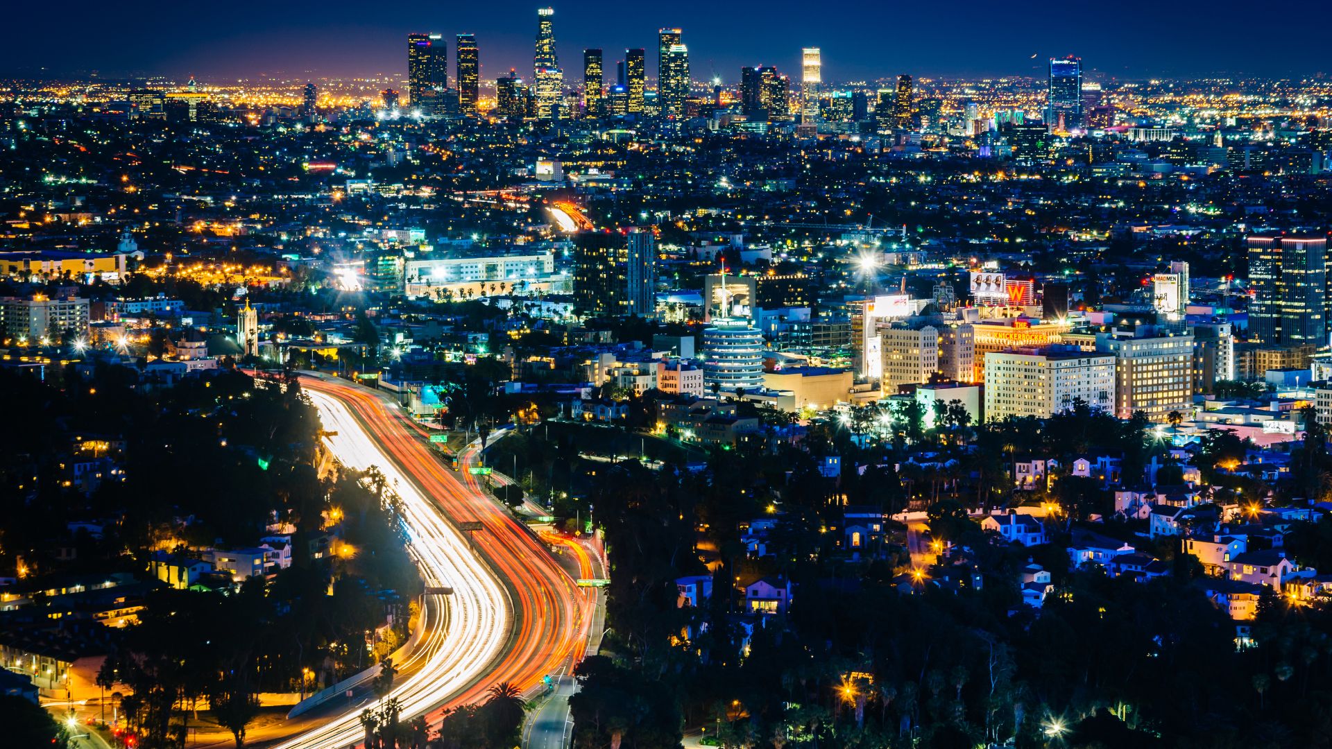
Mulholland Drive and Hollywood Bowl Overlook: Iconic Urban Vistas
Mulholland Drive snakes along the Santa Monica Mountains, giving you a front-row seat to LA’s skyline and a surprising dose of wildness right in the city.
Panoramic Views from the Hollywood Bowl Overlook
You’ll find the Hollywood Bowl Overlook at 7036 Mulholland Drive. It’s famous for a reason—the city just stretches out below you, perfect for photos. I caught a sunset here, and watching the lights flicker on as the sky turned orange was unforgettable.
Even when there’s a crowd, the overlook feels open and calm. Benches and maps help you pick out landmarks like Griffith Observatory and the downtown towers. I saw all sorts of people—tourists, couples, families—pointing out their favorite spots.
Parking’s easy, so you can just pull over and soak it in. After dark, the city lights are pure magic. No wonder movie directors keep coming back to this spot; it’s dramatic, but also has a kind of quiet charm.
Hidden Corners of the Santa Monica Mountains
Mulholland Drive hides a few surprises. I found smaller pullouts and trailheads tucked between sharp turns. While everyone stops at the main overlook, these quieter spots gave me a break from the crowds.
Some lookouts show off the deep canyons and rugged slopes of the Santa Monica Mountains. I drove past chaparral and old oaks, and even spotted a few cyclists disappearing into side trails.
Here’s what I loved about these hidden corners:
- Quieter, more private viewpoints
- Closer looks at native plants and wildlife
- Quick access to hiking trails
- Cool shade under big old trees
Mulholland isn’t just about the city skyline—it’s also a backdoor into LA’s wilder side. Each stop brings a new angle on both the city and the mountains.
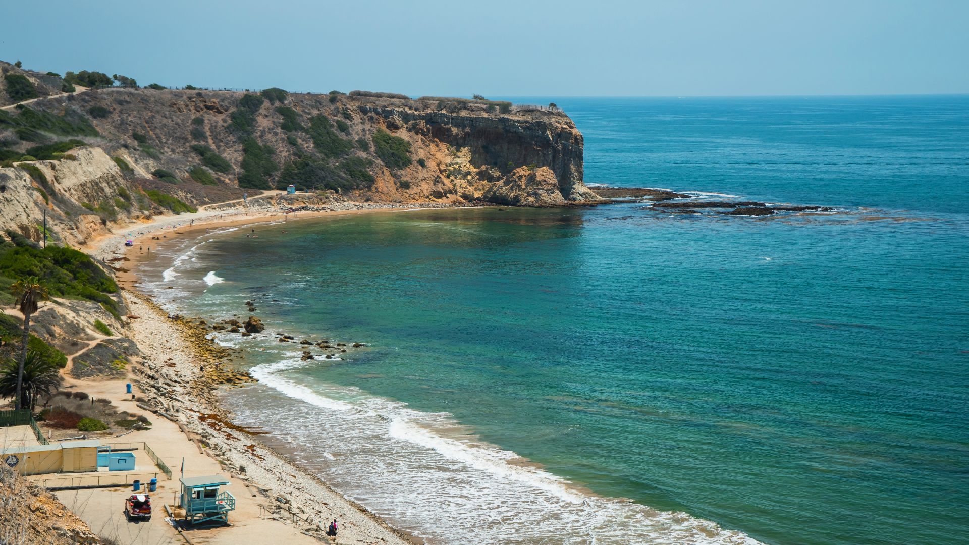
Palos Verdes Drive: Dramatic Cliffs and Ocean Views
Palos Verdes Drive completely won me over with its rugged cliffs and sweeping ocean views. Unlike PCH, it’s quieter and the scenery feels more untouched.
Best Vista Points along the Coast
Cruising Palos Verdes Drive, I kept pulling over for the vista points. Point Vicente stands out, with its lighthouse and a friendly interpretive center. From those bluffs, on a clear day, you can spot Catalina Island and sometimes dolphins playing below.
At Terranea Resort, public trails lead to grassy lawns perched above the water. I watched waves slam into the rocks from a little cove there. Abalone Cove Shoreline Park was another favorite—tide pools, rocky beaches, and a killer view down the coast.
Key Vista Points:
| Stop | Feature | Notes |
|---|---|---|
| Point Vicente | Lighthouse, ocean views | Great for whale watching |
| Terranea Trails | Bluffs, grassy areas | Easy walking paths |
| Abalone Cove | Tide pools, rocky coast | Steep trails, awesome photos |
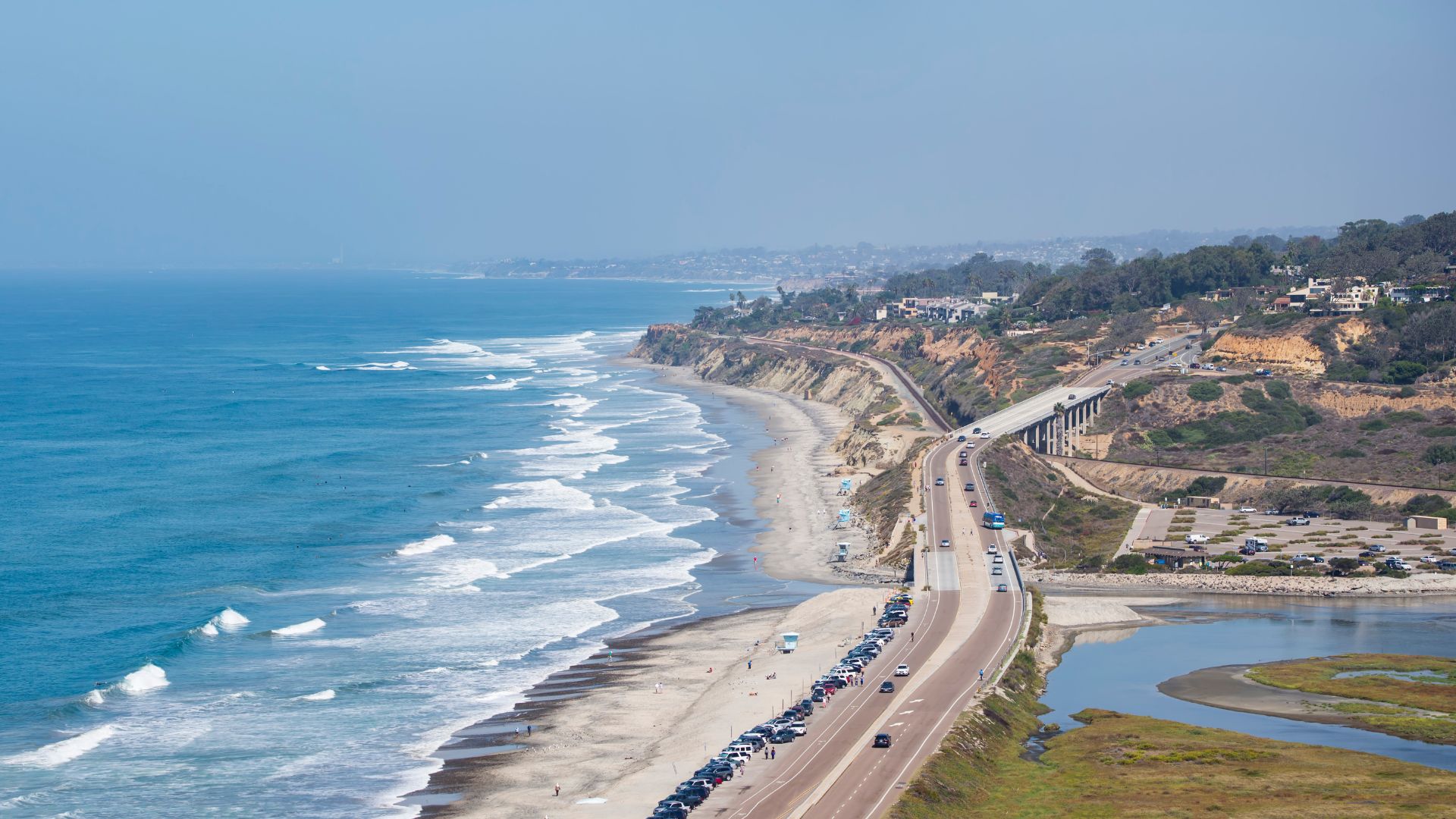
Malibu to Palos Verdes: Alternative Coastal Drives
While PCH is the classic, I’ve found the coastal drives connecting Malibu and Palos Verdes have their own charm. Sometimes I skip the main drag and take Palos Verdes Drive West or South for a fresh view.
These roads stay quiet and offer more dramatic cliffs than most of PCH. Heading south from Malibu, the scenery shifts from broad beaches to rocky bluffs and ocean overlooks.
Some stretches hug the edge, and in late afternoon the light turns the coastline golden. I love that you can pull off for a photo or a quick walk almost anywhere. The mix of high roads and endless water makes this drive feel totally different from the busier highways.
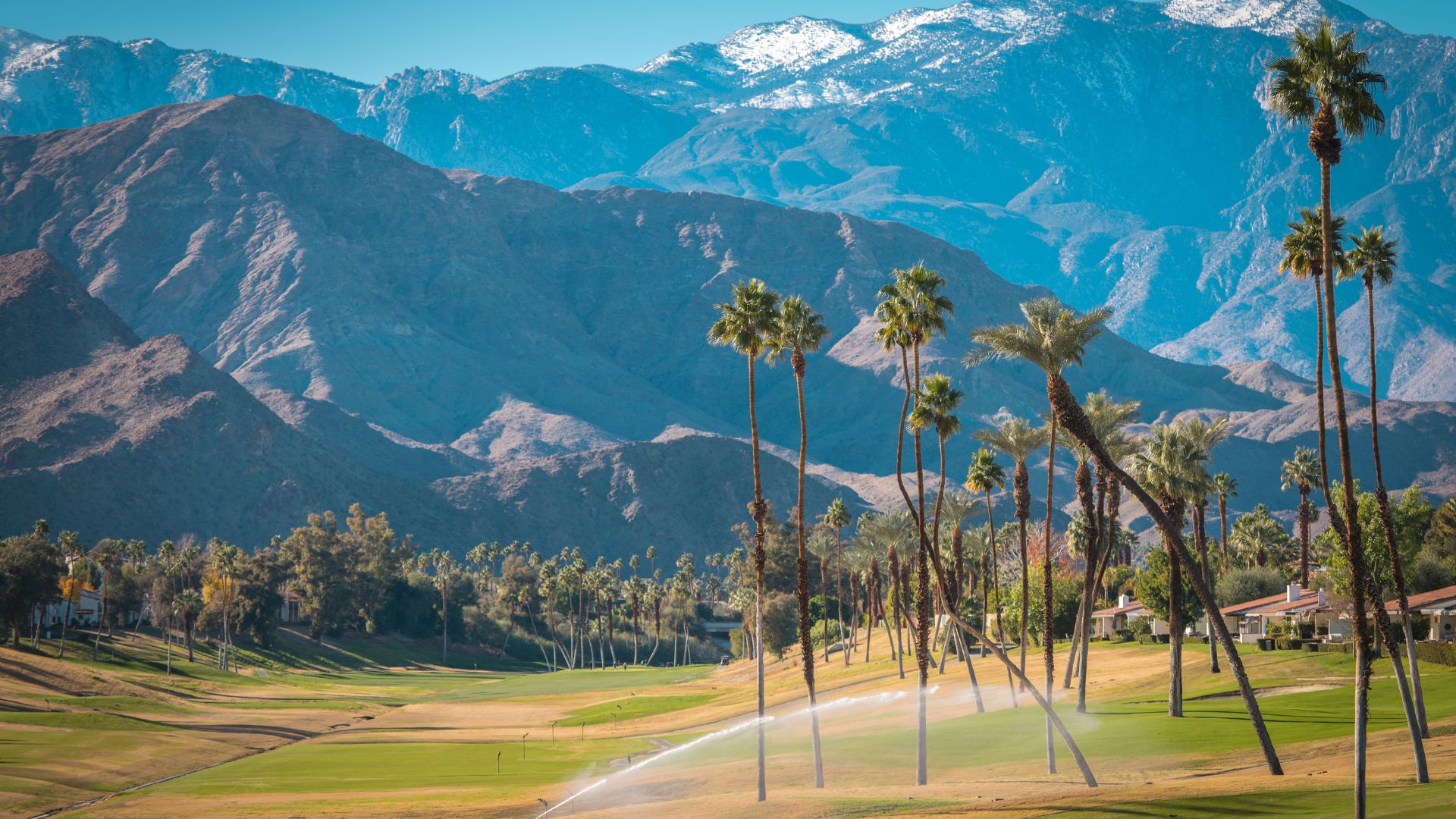
Palm to Pines Scenic Byway: From Desert to Mountain Marvels
The Palm to Pines Scenic Byway packs a punch—one minute you’re in the desert, and the next you’re winding through cool mountain forests. It’s a wild change of pace and scenery.
Transition from Palm Desert to Forested Peaks
Starting in Palm Desert, I watched the road climb fast. The temperature dropped, and suddenly the cacti gave way to rocky hills, then pines.
Highway 74 stands out for its sharp turns and big drops, revealing huge views over the Coachella Valley. I stopped at every overlook I could, just to breathe in the crisp air and snap some pictures.
The drive takes you through the Santa Rosa and San Jacinto Mountains. I’d leave the desert behind and find myself surrounded by forests—sometimes even snow at the peaks, depending on the season.
What I love most? In under an hour, you can go from blazing desert to shady green woods. The constant change keeps things interesting.
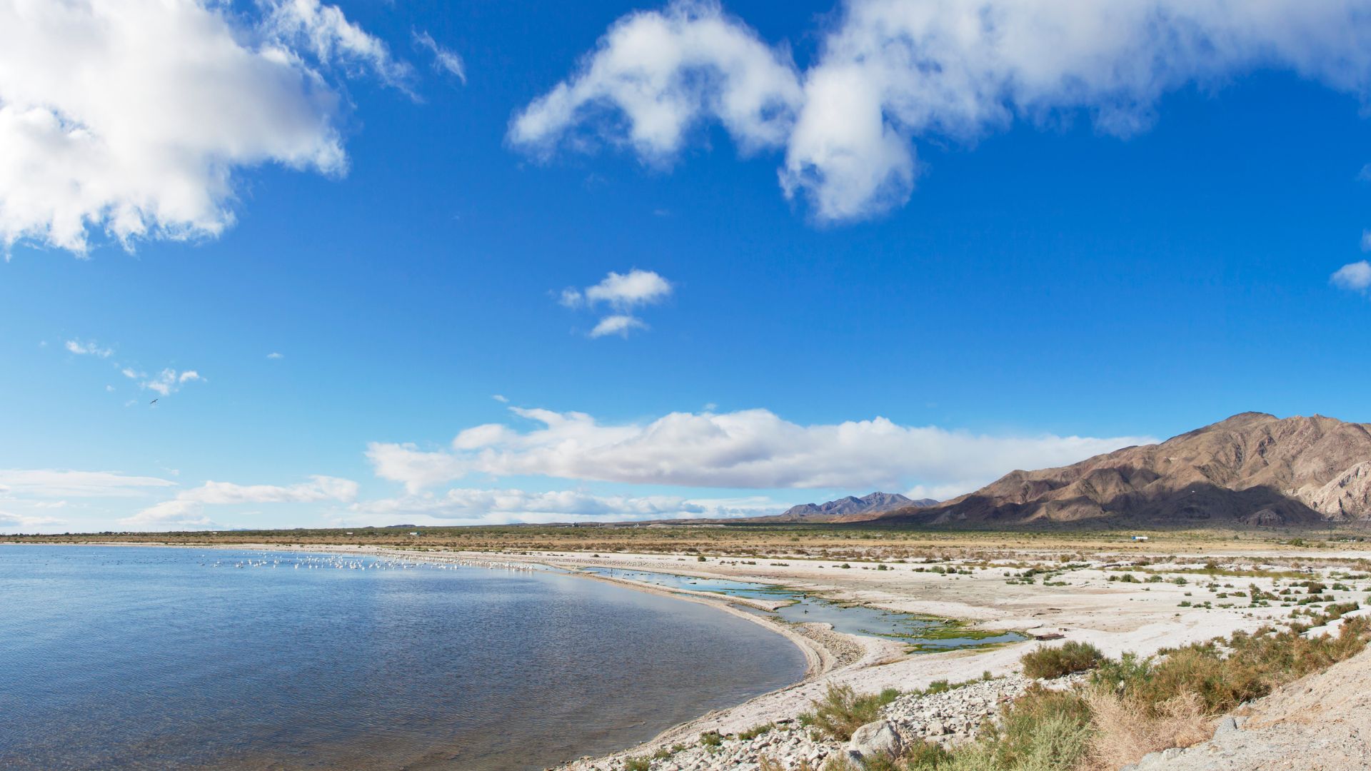
Notable Attractions: Salton Sea and San Bernardino Mountains
Along this route, I made a detour to the Salton Sea. It’s a weird, fascinating place—an accidental lake from the early 1900s, now ringed by quiet desert towns and strange beauty.
Further along, the San Bernardino Mountains come into view. I crossed high passes with wide-open vistas over both desert and forest.
Some favorite stops:
- Vista Point overlooks for those big views
- The artsy little town of Idyllwild, perfect for coffee or a stroll
- Hiking trails, from easy walks to longer forest adventures
Every time I drive the Palm to Pines Byway, I’m surprised by how much changes along the way. It’s like several trips packed into one.
Bonus Explorer’s Picks: Lesser-Known Scenic Routes
Beyond the big-name coastal drives, I’ve found a few routes in Southern California that deliver their own unique views and peaceful backroad vibes. Each one offers something different—think forested hills, twisty canyons, or mountain lookouts you’ll have all to yourself.
Ortega Highway
Ortega Highway (Highway 74) winds between San Juan Capistrano in Orange County and Lake Elsinore. This stretch of road pulls you up steep cliffs, then drops you into thick patches of Cleveland National Forest, twisting past overlooks that almost beg you to stop.
I always keep an eye out for motorcyclists and sports cars zipping around the curves. They love this highway, and honestly, who can blame them?
Sometimes I’ll pull off at one of the turnouts to snap a photo of the rolling hills or catch a glimpse of distant lakes. On weekdays, the road feels a lot quieter, which makes it easier to find those peaceful moments.
I think the best spots usually sit around the Ortega Oaks Candy Store or near Caspers Wilderness Park. The highway gets surprisingly remote in places, even though city life buzzes just a few miles away.
That blend of mountains and canyons? It’s something you just don’t find in most of Orange County.
Quick highlights:
- Approximate distance: 32 miles
- Best for: Mountain and canyon views, forested scenery
- Stop at: Ortega Oaks, Caspers Wilderness Park
Jacinto Reyes Scenic Byway
The Jacinto Reyes Scenic Byway doesn’t get much traffic, but wow, the views of Los Padres National Forest really deliver. Starting near Ojai, I head north on State Route 33.
The road climbs fast, winding through oak woodlands and then suddenly opening up to big valley views and rugged ridgelines. It’s the kind of place where you can just pull over and breathe for a minute.
I love how the landscape shifts so quickly. Chaparral gives way to pine forests as you gain elevation, and sometimes a little creek pops up or a picnic area appears out of nowhere.
Historic sites dot the route, but honestly, I often just enjoy the quiet. Traffic stays light, so there’s no rush.
I always toss snacks and extra water in the car since you won’t find many services out here. For anyone who wants to see a quieter, wilder side of Southern California’s mountains, this drive is a gem.
Quick highlights:
- Approximate distance: 38 miles
- Best for: Forested mountains, quiet vistas
- Stop at: Pine Mountain, Rose Valley
Live Oak Canyon Road
Live Oak Canyon Road twists not far from Redlands, and it’s a local favorite for a reason. Old oaks line the way, tall grass waves in the breeze, and you’ll spot a few country homes with horses or cows grazing nearby.
There’s something peaceful about how secluded it feels, even though you’re just minutes from town and the main highways. The curves here are gentle, so I find it relaxing to cruise, especially when the sun’s coming up or going down and the light filters through the branches.
Every now and then, I’ll stop at a fruit stand or a little farm for something fresh. The road isn’t long, but it makes a great detour if you need a break from the faster pace.
Quick highlights:
- Approximate distance: 10 miles
- Best for: Oak-lined curves, rural ranch views
- Stop at: Local fruit stands, picnic spots
Sunrise Scenic Byway and Palomar Mountain Loop
Driving the Sunrise Scenic Byway, which connects to the Palomar Mountain Loop, always feels like an adventure through San Diego County. I wind through the Laguna Mountains, spotting wildflowers in the spring and passing shady pine groves.
Sometimes I catch glimpses of hikers or cyclists weaving along the trails. The sky? It can be absolutely unreal at sunrise or sunset—no wonder they named the byway after it.
Once I hit the Palomar Mountain Loop, the road really starts to climb. I get those high-elevation twists and some rare, sweeping views across the Cleveland National Forest, all the way out to the Pacific on a clear day.
There are pull-offs where I can park and just take it all in. On especially clear days, I’ve even seen all the way to Mexico or deep into the mountain valleys.
It’s usually pretty quiet out here, but the weather likes to keep me on my toes. I always check the forecast before heading out—conditions can change in a snap.
Quick highlights:
- Approximate distance: 36 miles (including the loop)
- Best for: Mountain drives, panoramic viewpoints
- Stop at: Laguna Meadows, Palomar Observatory, mountain overlooks