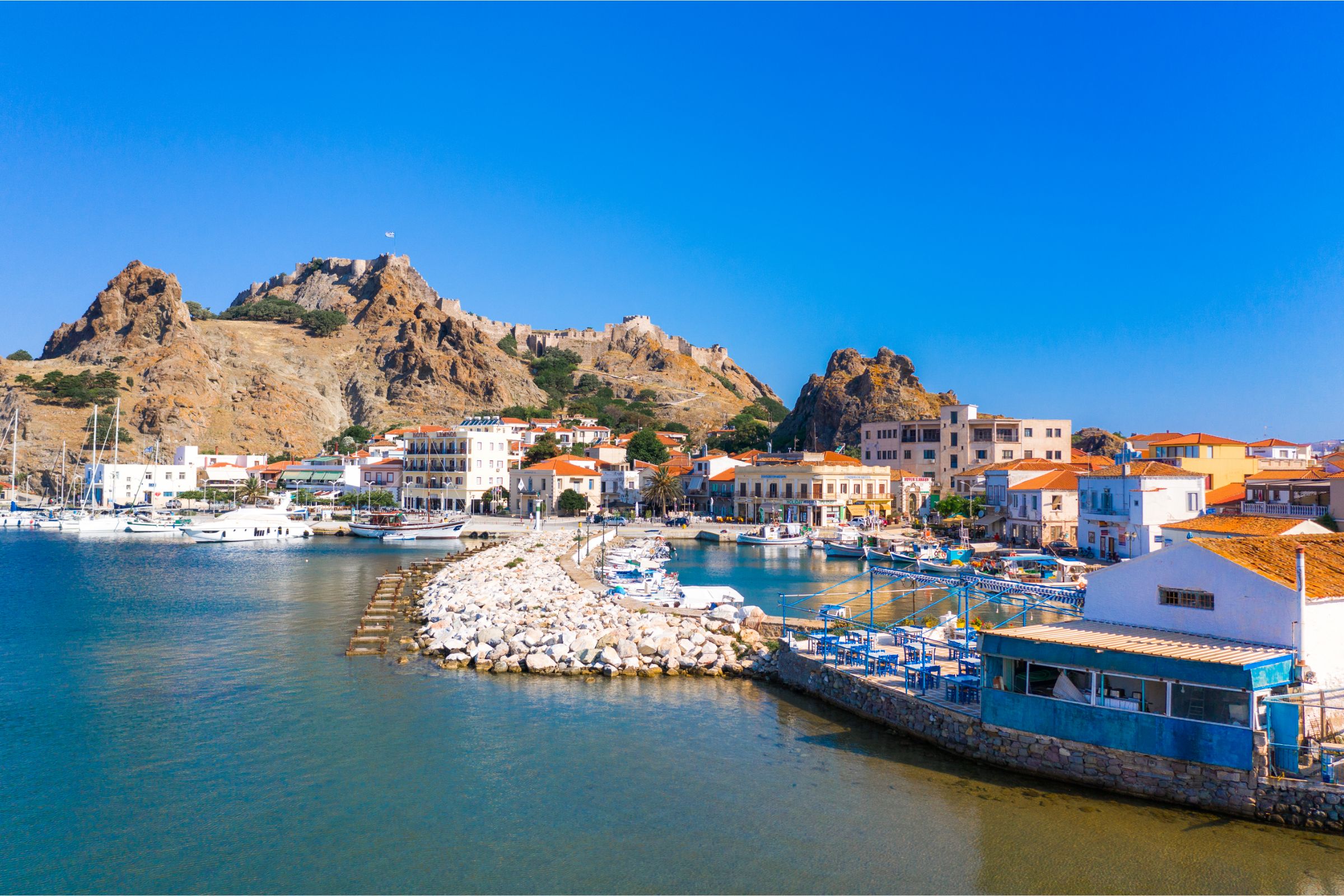
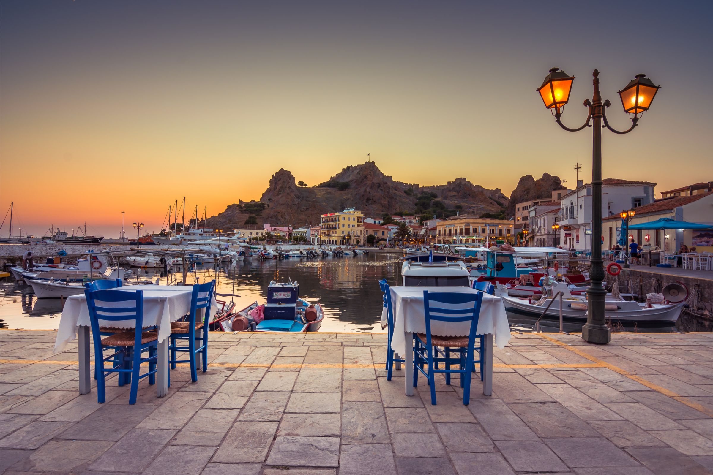
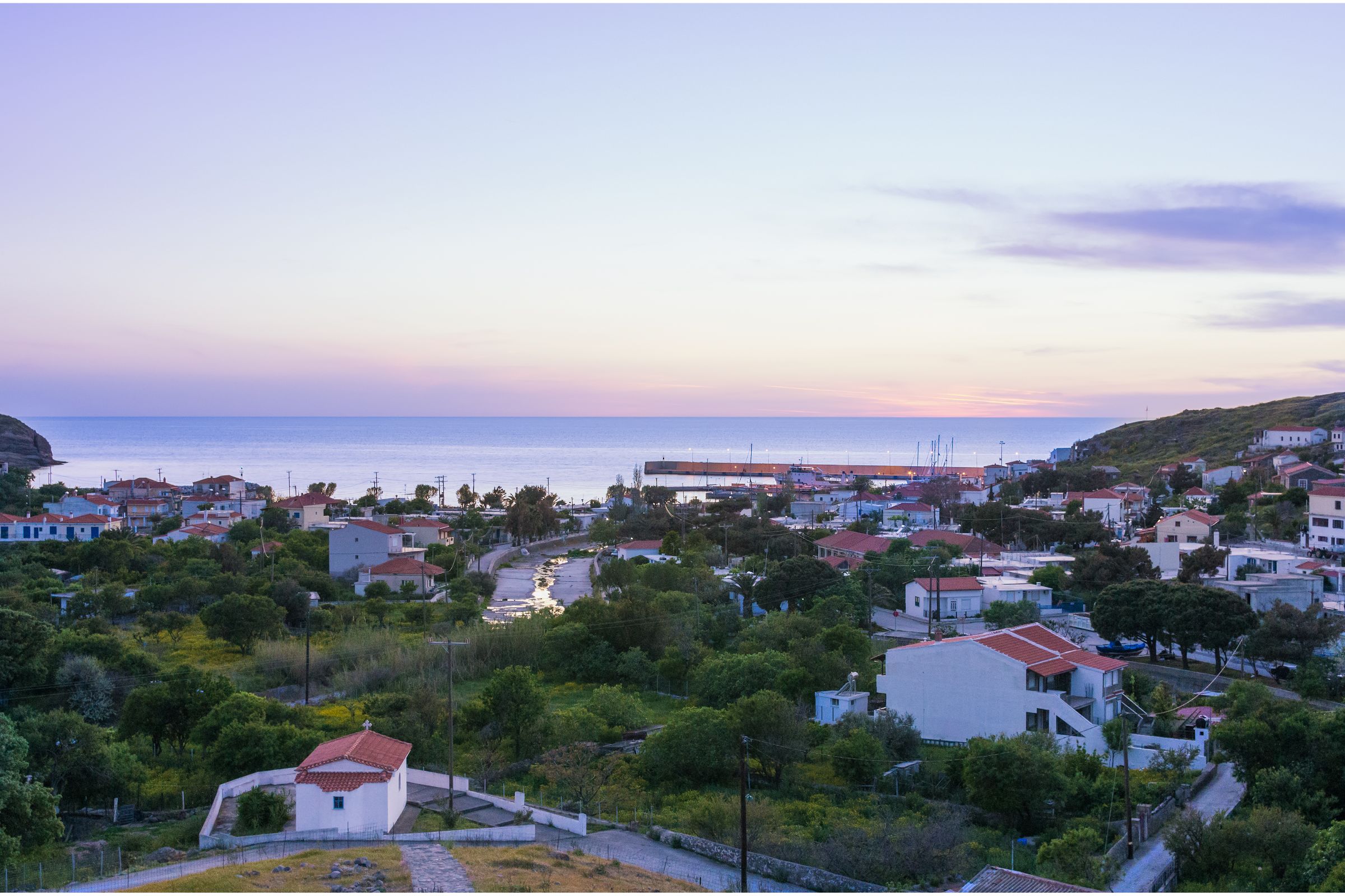
Myrina immediately pulled me in the moment I hopped off the ferry. This Greek island port, the capital of Lemnos, wraps itself around two sparkling bays. A medieval Venetian castle perches on a rocky peninsula between them, watching over the town.
What really sets Myrina apart? It’s the slow, relaxed pace—and the wild deer that wander freely inside those ancient fortress walls. Honestly, I didn’t expect to see deer mingling with medieval ruins, but here they are.
Myrina’s twin harbors, historic castle, and gentle island rhythm create a destination that’s surprisingly enchanting. It’s a world away from Greece’s bustling tourist hotspots.
I wandered through Byzantine foundations and Venetian ramparts, then down streets lined with neoclassical mansions and old Ottoman buildings. The blend of old and new gives the town a unique energy.
Myrina feels like a place where history and modern island life just coexist naturally. The town makes a perfect base for exploring Lemnos’s volcanic landscapes and archaeological sites. At the same time, it remains the island’s main port and administrative center.
If you love medieval fortresses, peaceful bay views, or just want a taste of real Greek island culture, Myrina will probably win you over.
Myrina’s Twin Bays and Port Town Ambiance
Myrina stretches around two bays that shape its very soul. Each bay has its own vibe, and together they define the town’s character.
The waterfront bustles with daily life and commerce, but it never loses that laid-back island tempo. You can feel it in the air—nobody’s in a hurry here.
A Town Shaped by the Sea
The twin bays form a natural harbor. The town kind of hugs them, curving around like an embrace.
The northern bay acts as the main commercial port. Ferries come and go, linking Lemnos to mainland Greece and other islands.
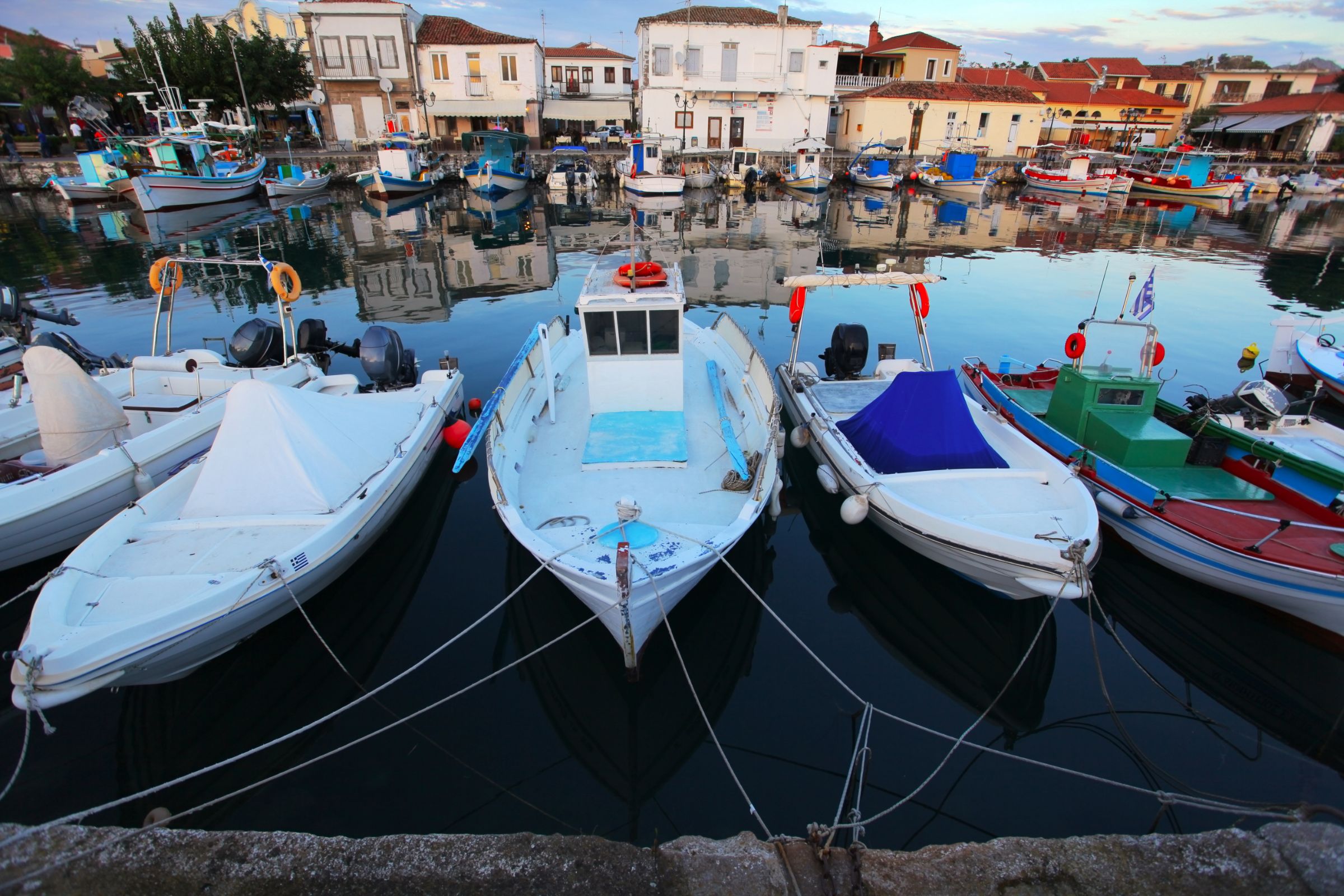
The southern bay feels calmer. Fishing boats and pleasure craft bob gently in the protected waters.
Right between the two, the rocky peninsula rises up, crowned by the Venetian castle. The fortress commands sweeping views of both harbors—no wonder they built it there.
A wide promenade links the bays, making it easy to stroll from one to the other. I found myself walking that route often, just watching how each bay pulses with its own rhythm.
Key Bay Features:
- Northern bay: Main ferry terminal, commercial activity
- Southern bay: Fishing harbor, recreational boats
- Rocky peninsula: Natural barrier, forms the twin-bay shape
The Lifestyle and Pace of Myrina
Life in Myrina moves to a gentle beat, always in sync with the sea. Locals seem to time their days around the arrival of ferries and the tides.
Early mornings, fishing boats glide in with their catch. The little fish market by the port buzzes as vendors set out fresh seafood.
By afternoon, families gather at waterfront cafes. The promenade turns into a social hub, with locals and visitors mingling over coffee or ouzo.
Daily Rhythms I Noticed:
- 6-8 AM: Fishing boats come home
- 10 AM-12 PM: Ferries arrive, the northern bay perks up
- 5-7 PM: Evening strolls along the waterfront
- 8-10 PM: Taverns and restaurants fill up
Even when ferries unload crowds, the town stays friendly and mellow. There’s a real sense of calm that’s hard to find elsewhere.
Port Activities and Local Commerce
The port is the heart of Myrina’s economy. As Lemnos’s main gateway, it handles both travelers and cargo all year.
Ferry connections link Myrina to Piraeus, Thessaloniki, and other islands. The island relies on these routes for supplies and, of course, tourism.
Fishing boats cluster in the southern bay. I’d watch crews untangle nets and fix up their boats in the early light.
The waterfront hosts a mix of local businesses that keep things lively:
| Business Type | Location | Primary Function |
|---|---|---|
| Tavernas | Along both bays | Fresh seafood dining |
| Cafes | Northern waterfront | Social gathering spots |
| Shops | Behind port area | Local products and supplies |
| Boat services | Southern bay | Fishing and excursions |
Small cargo ships bring in everything the island needs, from building materials to groceries. The port keeps Myrina supplied, but it never feels too busy.
I loved how the town manages to be a working port and a peaceful getaway at the same time.
Venetian Castle: History, Fortifications, and Resident Deer
Myrina Castle looms above the port, one of the Aegean’s largest fortresses. Built on volcanic rock, this ancient stronghold has seen Byzantines, Venetians, and Ottomans come and go. Now, about 70 deer wander its ruins—yes, really.
Timeline of the Castle: Byzantines, Venetians, and Ottomans
The castle started as a Byzantine fortress. Then in 1207-1214, Venetian leader Filocalo Navigajiosi rebuilt it into a serious stronghold.
The Venetians controlled Myrina during three separate stretches. Their first run lasted from the early 1200s to 1279. The Byzantines took over until 1453, then the Venetians came back twice more.
The Ottomans seized the castle in 1479 and held on for almost four centuries. They even built a mosque inside—its remains are still there if you look closely.
In 1770, the Russian fleet damaged the castle during a siege. Greece finally took over in 1912, ending all those centuries of foreign rule.
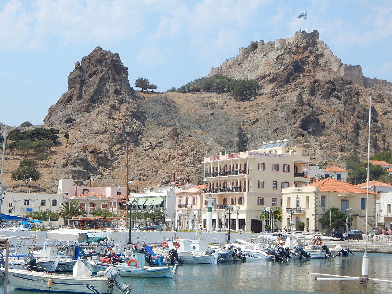
Image Source: Wikimedia Commons
Architectural Features and Strategic Importance
The castle sits on a steep, rocky peninsula, only accessible from the east. Attacking from the other sides? Pretty much impossible.
The fortress walls impress with their sheer size and clever design. The Venetians used the natural volcanic stone, adding strength and style.
Each group—Byzantines, Venetians, Ottomans—left their own mark. Repairs and additions tell the story of shifting power.
Inside, you’ll find rooms and steps carved right into the rock. These spaces served all sorts of purposes over the years.
Deer of Myrina Castle: Origins and Current Role
Today, about 70 “Platoni” deer live inside the castle walls. Locals sometimes call Myrina “Kastro” because of these animals.
The deer have become a quirky symbol of the place. I watched them wander among the ruins, totally unfazed by visitors.
They give the castle a gentle, almost magical vibe. Tourists love them, and honestly, so do I.
The deer population seems to be holding steady. They’ve adapted to castle life and add something special to every visit.

Image Source: Tripadvisor
Guided Tours and Visitor Experience
You can visit the castle any time of year. It’s a short walk from Myrina’s town center, so getting there is easy.
A 3D guided tour helps you make sense of the castle’s layout and history. The tour covers different eras and the fortress’s many changes.
Walking through the ruins, I paused at the east wall—what a view! From up there, Myrina’s twin bays look even more stunning.
Between the crumbling stone and the deer, the castle offers a unique experience. I spent hours exploring, never quite ready to leave.
Exploring Old and New Myrina
Myrina blends centuries of history with the rhythm of modern island life. Ancient ruins whisper of Byzantine and Venetian days, while neoclassical mansions hint at 19th-century prosperity.
Wandering Through Ancient Myrina
The old town sprawls beneath the castle, layer upon layer of history. I wandered narrow cobblestone streets that haven’t changed much in centuries.
Stone archways connect old buildings—some once home to Byzantine merchants. These passages offer cool shade on hot days.
Key historic spots worth a look:
- Byzantine church ruins near the castle
- Ottoman-era neighborhoods below the fortress
- Ancient stone foundations scattered through the old town
The lively Nefelis marketplace leads right to the castle steps. Shops now fill medieval buildings once used by traders from all over.
Volcanic rock shapes the town’s layout. Buildings curve around outcroppings, the old architects working with the land, not against it.

Neoclassical Mansions and Town Landmarks
Along the waterfront and main squares, Myrina’s neoclassical mansions stand tall. Built in the late 1800s, they reflect a time when trade brought wealth to the island.
These mansions feature tall windows, bright shutters, and little balconies with iron railings. Some now house museums or cultural centers.
Look for these architectural touches:
- Carved stone doorways
- Red-tiled roofs, classic for the Aegean
- Two-story layouts with shops below
Platia Eleftheriou Venizelou is the main square. The neoclassical town hall dominates one end, while cafes fill the rest.
Down by the harbor, the grandest mansions line up. Ship captains and merchants built them to show off their status. Today, they make a picture-perfect backdrop for fishing boats.
Local Culinary Delights: Pastries and Cafes
Myrina’s pastries reflect its mix of cultures. Bakeries tempt with classic Greek sweets and Lemnian specialties.
I tried galaktoboureko made with local sheep’s milk—so creamy, richer than what I’ve had elsewhere. Honey cookies called melomakarona use thyme honey from the island.

Tasty local treats to sample:
- Kaltsounia (cheese pastries with mizithra)
- Baklava with Lemnian walnuts
- Loukoumades drizzled with local honey
Cafe life centers on the harbor and main square. Family-run spots serve Greek coffee in brass pots. Fishermen stop by early, but the cafes stay lively well into the night.
Pastry shops fill their glass cases with fresh phyllo treats each morning. The scent of baking bread and sweets drifts through the old streets at dawn.
Nature, Surroundings, and Island Connections
Myrina’s spot on Lemnos offers sweeping views across twin bays and easy access to nearby North Aegean islands. Close villages like Platy and Kornos offer a deeper taste of authentic Greek life.
Scenic Views and Twin Bays from Above
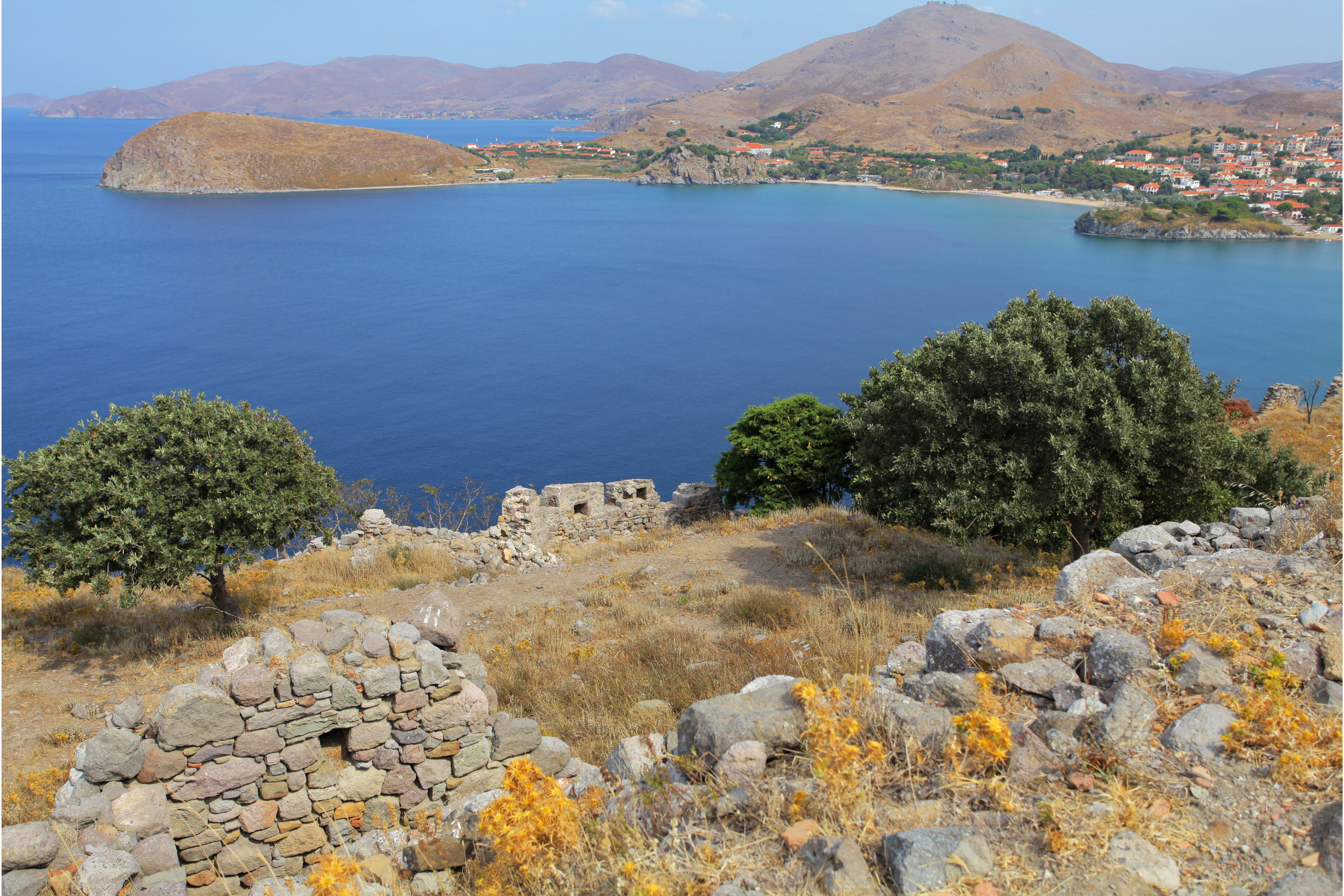
Climbing up to the Venetian castle, I took in Myrina’s most dramatic view—the twin bays stretching toward the Aegean. Volcanic rocks frame the blue water below.
From the castle, you can see the whole town wrapping perfectly around both bays. The northern bay hosts the main port and ferries, while the southern bay is quieter, dotted with fishing boats.
Lemnos’s volcanic landscape creates striking contrasts. Dark rocks, whitewashed buildings, and the deep blue sea—honestly, it’s hard to beat.
At sunrise, the twin bays glow with shifting colors. It’s worth getting up early just to watch the light change.
Nearby Villages: Platy and Kornos
Platy sits just 2 kilometers south along the coast. This fishing village serves up excellent seafood in tavernas with harbor views. The beach here is longer and sandier than Myrina’s, with calm, shallow water.
Local fishermen still work from Platy’s little harbor. I watched them patch nets and prep boats at dawn. The place keeps old island traditions alive.
Kornos lies inland, about 6 kilometers northeast of Myrina. This farming village produces some of Lemnos’s best wine and cheese. I stopped by local producers who happily offered tastings.

Image Source: Wikimedia Commons
The ride to Kornos winds through hills covered in vineyards and ancient stone walls. Families have worked these fields for generations, and you can feel that deep connection to the land.
Lemnos’ Link to Samothrace, Thasos, and Agios Efstratios
Ferries from Myrina’s port open up Lemnos to the rest of the North Aegean. I jumped on these routes to check out more of the region—honestly, it’s one of the best ways to island-hop around here.
Samothrace sits about 50 kilometers northeast, and in summer, you’ll find ferries heading there several times a week. This island feels wild and rugged, with dramatic mountains, hiking trails, and the ruins of an ancient sanctuary that’s just waiting for explorers.
Thasos is a bit of a trek since you have to connect through Kavala on the mainland. It takes most of a day, but you’re rewarded with pine-covered hills, marble beaches, and that classic laid-back island vibe. If you’ve got the time, it’s a solid choice.
Agios Efstratios is the closest option, just 30 kilometers to the southwest. This tiny volcanic island only has one village and a handful of untouched beaches. Ferries run twice a week in summer, so you’ll want to plan ahead if you’re hoping to visit.
Ferry schedules always seem to shift with the seasons. From what I’ve seen, summer brings the most options and flexibility for connections.
Modern Myrina: Information and Orientation
Myrina stands as the capital and main port of Lemnos, right on the island’s western coast. It’s the heart of the North Aegean, and you’ll notice its strategic spot as soon as you arrive.
The town acts as the administrative center for all of Municipality Lemnos. If you’re trying to get your bearings, modern mapping apps and even a quick satellite view make it easy.
Location and Municipality Structure
You’ll find Myrina on Lemnos’s west side, tucked into the North Aegean region of Greece. It’s the capital of Municipality Lemnos, which came together in 2011 when several smaller municipalities merged.
The municipality actually covers the whole island—about 477 square kilometers in total. Myrina handles all the main administrative services, so it feels like the island’s nerve center.
Population here isn’t set in stone. In winter, about 5,000 people call Myrina home. When summer rolls in, tourists and seasonal locals push those numbers way up.
Myrina’s port keeps Lemnos connected to mainland Greece and the neighboring islands. Ferries head out to Piraeus, Thessaloniki, and other Aegean spots pretty regularly. The main airport sits just outside town, so arrivals and departures are a breeze.
Maps and Satellite Imagery
Pull up any satellite image, and you’ll spot Myrina’s twin-bay setup right away. The town stretches between two natural harbors, split by the rocky castle peninsula.
Plug in the GPS coordinates—39.8733°N, 25.0681°E—and you’ll land right in the heart of town. Most navigation apps show the street layout and key landmarks without any fuss.
Google Maps and similar apps lay out the pedestrian zones, parking, and main roads. I leaned on these a lot, especially when weaving through the narrow harbor streets.
The castle dominates every aerial view, jutting out between the two bays. You can see how compact and walkable Myrina really is, which makes it easy to explore on foot.
Multilingual Names and Regional Placement
You’ll notice that Myrina pops up with different names, depending on the language or the map you’re looking at. In Greek, people write it as Μύρινα. Some older maps? They’ll call it Kastro, thanks to that impressive castle watching over the town.
Administratively, the town sits in the North Aegean region. So it’s grouped with islands like Lesvos and Chios. Still, Lemnos has always kept its own unique vibe and handles a lot of its own local affairs.
If you’re digging through Italian sources from the Venetian era, you’ll spot the name “Mirina.” Turkish records might mention “Kastro” or toss in a few Ottoman twists. These days, international signs usually stick with the Greek transliteration: “Myrina.”
The island of Lemnos itself hangs out between mainland Greece and Turkey. It’s about 50 kilometers from the Turkish coast. You can really feel how this spot shaped Myrina’s history and the way the town feels today.