When I first set foot on the Palm Springs Aerial Tramway, I honestly didn’t expect the world to change so fast. In about ten minutes, I went from the blazing desert floor straight up into cool, green forests high in the San Jacinto Mountains.
That ride covers over 8,500 feet of elevation. I watched the landscape morph right outside the tram’s windows—pretty wild, honestly.
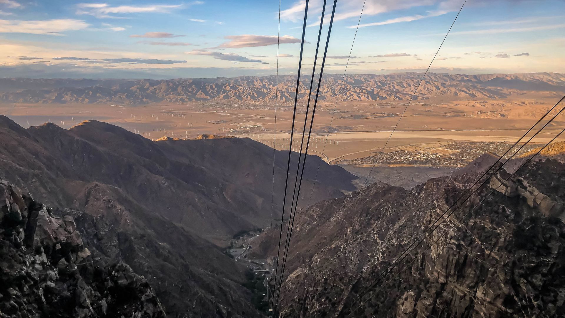
Every moment in that rotating tramcar brought a fresh scene. Sometimes it was rocky canyons, sometimes sweeping views across Palm Springs and the valley below. It’s like jumping through different climates in a blink.
If you want something unique with jaw-dropping scenery, this tramway is hard to beat in California.
I’m sharing my experience so you get a real feel for what it’s like to travel from desert heat to alpine air in just a few minutes.
The Palm Springs Aerial Tramway Experience
The Palm Springs Aerial Tramway whisked me from the sunbaked desert up to the shady alpine forest above in minutes. Along the way, I got to see some cool technical features and some of the best scenic views near Palm Springs.
What Makes the Tram Ride Unique
This tramway isn’t just a way to reach the top of Mt. San Jacinto. It’s an experience that’s perfect for sightseers and nature lovers.
The tram starts at Valley Station, sitting at 2,643 feet, and ends at Mountain Station, which is way up at 8,516 feet.
The ride climbs over two and a half miles. I watched the dry desert fade into thick pine forests and rocky cliffs, all in about ten minutes.
Your ticket covers the round-trip ride and gives you access to hiking trails, viewpoints, a restaurant, and even a small museum at the top. I shared the tram with other travelers snapping photos and soaking up the quick but ever-changing journey.
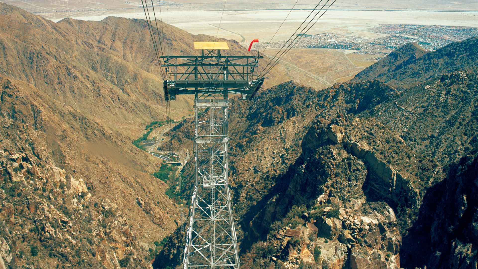
Rotating Tramcars and Engineering Marvels
The tram cars themselves are a bit of a marvel. They rotate slowly as they climb or descend, so everyone gets a 360-degree view without having to move around.
Not many tramways use this rotating floor system. As I stood inside, I noticed how the gentle turn made the ride feel smooth, even as we rose up the steep cliffs of Chino Canyon.
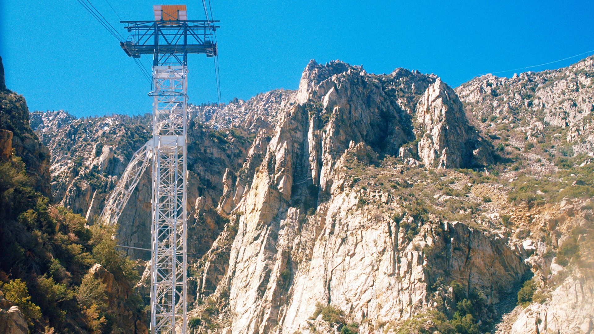
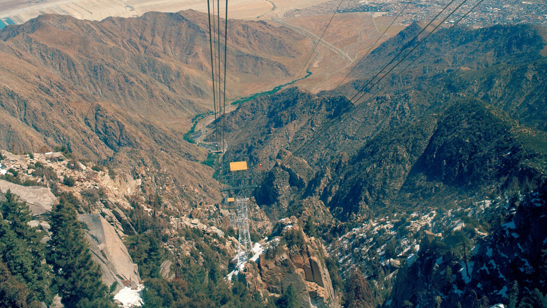
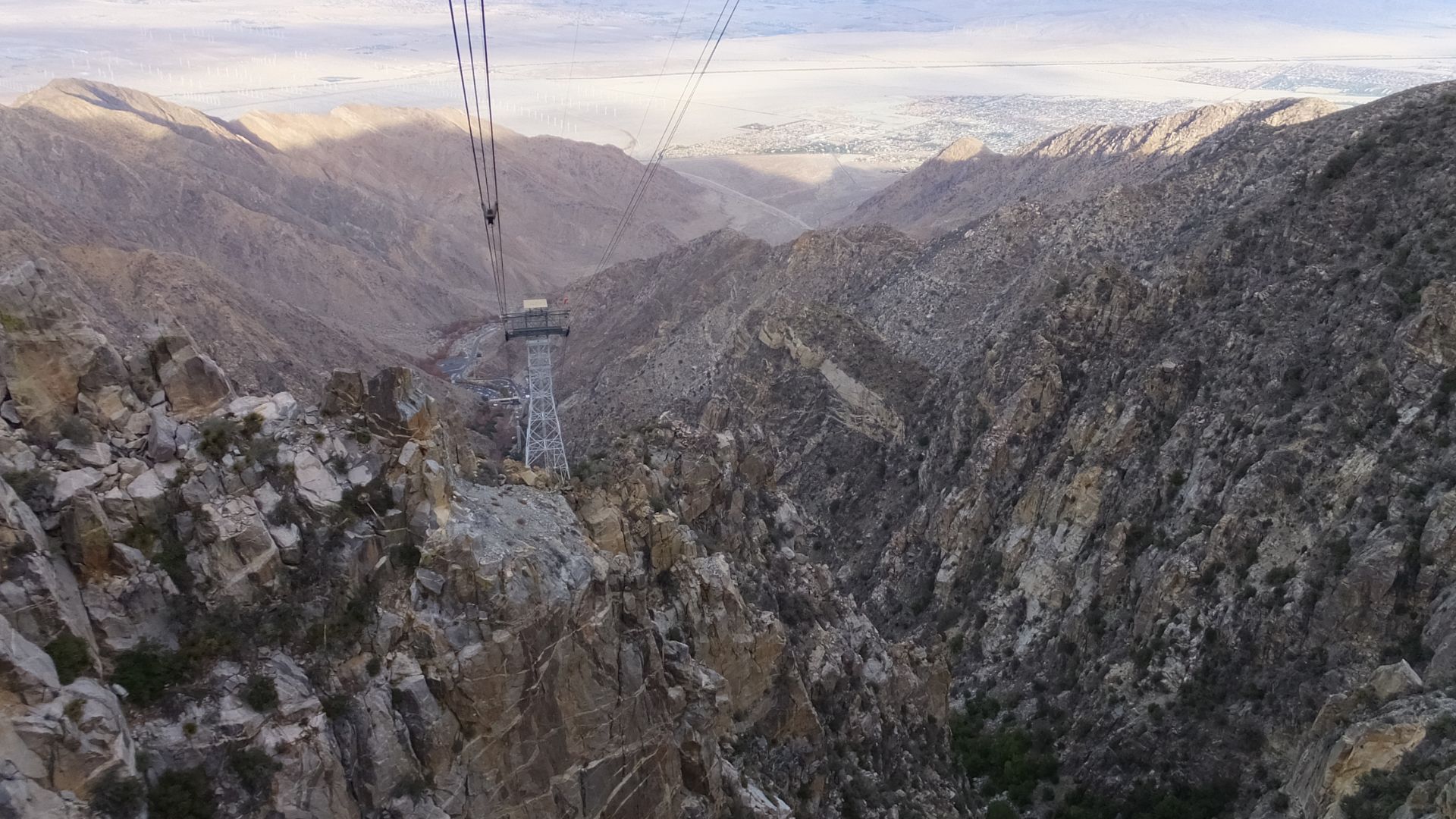
Five huge towers support the tramway’s cables. The steep climb, the long cables, and that unique rotating mechanism all work together to make the trip safe and memorable—even if the wind picks up.
Stunning Panoramic Views on the Journey
The views from the tram are honestly the best part. I could see the whole Coachella Valley, downtown Palm Springs, rolling desert hills, and even distant mountains.
As we climbed, the scenery changed fast. Cacti and desert rock gave way to pine trees and rugged cliffs. The tram’s glass walls made it easy to snap photos and just soak it all in.
The ride isn’t long, but every minute is packed with scenery. Looking out, I totally got why people call this one of the most breathtaking ways to see Palm Springs.
Preparing for Your Ascent: Planning, Tickets, and Logistics
Getting ready for the Palm Springs Aerial Tramway takes a little planning. You’ll want to sort out tickets, parking, and check the weather. Each step really does make the trip up to Mount San Jacinto State Park smoother.
Securing Tramway Tickets and Permits
I grabbed my tickets online ahead of time. They often sell out, especially on weekends and holidays, so it’s worth booking early on the official site.
Ticket prices vary for adults, seniors, and kids, so double-check the latest rates before you go. Planning to hike past the Mountain Station? You’ll need a free wilderness permit, which you can pick up at the ranger station at the top. But if you’re sticking near the Mountain Station or just strolling the developed paths, you don’t need a permit.
Parking and Valley Station Essentials
Parking at Valley Station is pretty straightforward, but it fills up fast during busy times. I got there early and had no trouble finding a spot. If the main lot fills, you can use overflow parking and just hop on a free shuttle to the entrance.
Inside Valley Station, you’ll find clean restrooms, a small gift shop, and a snack bar. I filled my water bottle, grabbed a trail map, and checked my ticket details with the staff. The signs make it simple to get from the parking lot to the tram entrance.

Weather Considerations and Seasonal Visits
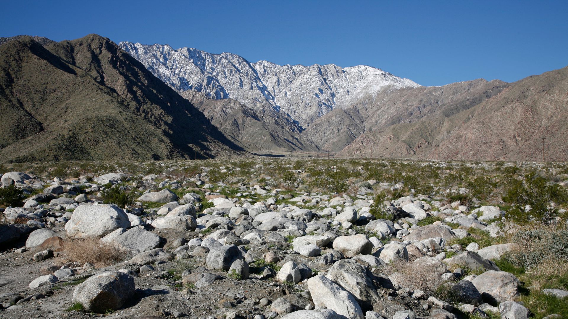
Weather changes fast between the desert floor and the top of Mount San Jacinto. The temperature can drop 30–40°F from base to summit.
I wore light clothes for the desert, but I packed a jacket and hat for the alpine forest. Checking the forecast a day ahead helped me avoid any surprises.
In winter, snow is common in the upper areas, and sometimes you need chains or snow tires for the drive to Valley Station. Summer brings cooler mountain air, but afternoon storms can roll in. I always check tramway alerts since high winds or storms can shut things down with little warning.
If you’re hiking or camping, bring extra layers and check for wilderness permit requirements at the ranger desk. Trail conditions and weather can change quickly, so pay attention to advisories at the station.
From Desert Floor to Alpine Forest: What to Explore at the Top
When I stepped out of the tram, the air felt crisp and the pine forest was thick all around. The change from desert to alpine wilderness hit me right away, and there’s honestly a lot to explore at the top.
Mountain Station Overview
Mountain Station sits at 8,516 feet, perched on the shoulder of Mount San Jacinto. Inside, I found a cafeteria, a gift shop, and a cozy lounge. Big windows let in tons of light and showed off sweeping forest views.
Right outside, well-marked trails start just steps from the station. I noticed signs for easy walks like the Desert View Trail and longer hikes that lead deeper into the Mount San Jacinto wilderness. Walking into the forest, I passed tall pines, giant boulders, and native shrubs. The cool air and scent of wood felt like a total reset after the valley heat.
Observation Decks and Breathtaking Lookouts
Just outside Mountain Station, outdoor observation decks wrap around the building. I leaned on the railings and just stared at the wild contrast—one way, thick pine forest; the other, a sharp drop to the dry desert floor.
Other visitors pointed out Palm Springs and distant mountain peaks. The decks have benches and even telescopes for a closer look. Early morning is magic for photos—the air’s clear, and the mountains practically glow.
If you’re up for more adventure, marked paths lead to higher lookouts in the alpine wilderness. Each one gives a new angle on Chino Canyon or the snow-capped peaks beyond.
Natural History Museum and Educational Features
Inside Mountain Station, I ducked into the small Natural History Museum. The exhibits explain the unique biodiversity of the San Jacinto area.
Displays cover local plants and animals, showing how they survive the alpine climate after that quick ride up from the desert. There are interactive maps, wildlife models, and photos of creatures like bobcats and bighorn sheep.
Info panels talk about the changing seasons and how snow shapes the ecosystem. I left with a new appreciation for the rare species that call Mount San Jacinto home—and why protecting them matters.
Outdoor Adventure: Hiking and Activities in Mt. San Jacinto State Park
Mt. San Jacinto State Park is a dream for anyone who loves the outdoors. Whether you’re into scenic hiking trails or winter sports, there’s something here for every nature enthusiast.
Popular Hiking Trails and Nature Walks
At the top of the tramway, I found more than 50 miles of trails winding through the San Jacinto Wilderness. San Jacinto Peak, at 10,834 feet, is the highest point and a big draw for hikers.
The Desert View Trail is great for beginners or families, with panoramic views in just 1.5 miles. For shorter nature walks, the Long Valley Discovery Trail loops a gentle half-mile through forest where I spotted deer and wildflowers.
The Nature Trail is another easy stroll, with signs that taught me about native plants and local biodiversity. If you want a real challenge, the hike to San Jacinto Peak is a full-day adventure with steep, rugged terrain. Round Valley is often a good rest stop before the summit.
Hiking Trail Quick Reference
| Trail Name | Distance | Difficulty | Highlights |
|---|---|---|---|
| Desert View Trail | 1.5 miles | Easy | Scenic lookout points |
| Long Valley Discovery | 0.5 mile | Easy | Wildlife and forest views |
| To San Jacinto Peak | ~11 miles | Strenuous | Summit, Round Valley, vistas |
Seasonal Snowshoeing and Cross-Country Skiing
In winter and early spring, snow blankets the ground around Long Valley and higher up. I’ve watched families and solo visitors bring snowshoes or rent them at the tram station.
Marked routes let you explore the forest on foot, even after a heavy snowfall. Cross-country skiing is another option, especially in the open meadows near Long Valley.
The trails aren’t always groomed, so I made sure to check conditions and bring the right gear. The forest feels extra peaceful in winter, with deer tracks in the snow and that satisfying crunch underfoot.
Mountain weather can turn fast, so I wore layers and kept a map handy.
Camping and Picnicking Opportunities
Camping in Mt. San Jacinto State Park lets you really soak in the mountain quiet. Round Valley campground is a favorite for wilderness camping, and you’ll need a permit, which I picked up at the ranger station.
Facilities are basic—no running water—but the campsites are shaded by tall pines. For day trips, I liked the picnic areas near the mountain station and trailheads.
Picnic tables sit under the trees, making it easy to relax before or after a hike. I always packed out my trash to help keep the area beautiful.
Wildlife is everywhere—squirrels, deer, even the occasional woodpecker. I kept my food stored away so I didn’t attract any curious critters. Camping and picnicking up here gave me time to slow down and just breathe in the cool mountain air.
Dining, Souvenirs, and Relaxation: Amenities at the Top
Once I reached the Mountain Station at over 8,500 feet, I found plenty of ways to unwind. Dining, shopping, and just kicking back all have their place here, so there’s something for everyone.
Dining Options and Peaks Restaurant
At the summit, you’ll find Peaks Restaurant—the main dining spot up there. Floor-to-ceiling windows give you sweeping views of the valley and mountains, which honestly, made my meal feel extra special.
The menu sticks to American classics. Think salads, sandwiches, roasted chicken—simple but satisfying after a day of exploring.
If you plan to eat here on a weekend, definitely try to snag a reservation. It gets crowded. The atmosphere feels peaceful, a nice contrast to the hustle at the lower station.
Craving something quicker or a bit more casual? The Mountain Station has a self-serve dining area that’s perfect for grabbing a bite without much fuss.
I didn’t expect much from the food, considering how remote it is, but Peaks surprised me. Sitting there with a warm meal, gazing out over the desert, just felt right.
Gift Shops and Unique Souvenirs
Right by the observation decks, there’s a gift shop packed with all sorts of souvenirs. You’ll spot plenty of tramway-branded stuff—shirts, hats, mugs, you name it.
They also stock postcards, local history books, and some cute toys. If you’re into practical souvenirs, you’ll find water bottles and even some hiking gear.
I grabbed a snow globe with the tram climbing the mountain—couldn’t resist. It’s a quirky little reminder of the trip. Prices didn’t shock me, given it’s a tourist spot, and honestly, the variety makes it easy to pick up a gift for someone back home.
The staff were genuinely friendly and happy to chat about the surrounding trails or share bits of tramway history.
Lookout Lounge and Pines Café
Need a snack or something quick? Lookout Lounge and Pines Café both have you covered. Pines Café runs cafeteria-style: pizza, sandwiches, hot dogs, drinks—the basics.
It’s a good spot for families, and the line actually moves fast. Meanwhile, the Lookout Lounge serves up drinks—cocktails, beer, wine. I noticed people unwinding there after a hike, just soaking in the view.
It’s a quieter place if you want to chat or simply stare out at the mountains. Having these different options made it so much easier to refuel, no matter how wiped out I felt after exploring.
Honestly, I appreciated not having to overthink what or where to eat. There’s something for everyone, which is a relief when you’re tired and hungry.
Discovering the Landscape: Geography, History, and Beyond
The Palm Springs Aerial Tramway climbs from the sunbaked floor of the Coachella Valley up into the cool forests of Mount San Jacinto. Riding the tram, I watched the scenery, culture, and even the air itself change with every passing minute.
Chino Canyon and Desert Landscape
My trip started in Chino Canyon, just outside Palm Springs. This place sits at the edge of the Coachella Valley, where the land is rocky and dry, broken up by cacti and low shrubs.
From the base, you can spot the shimmering Salton Sea way off in the distance. The heat down here is no joke—summer temps regularly soar past 100°F.
Once the tram lifts off, the view changes fast. Suddenly, you’re staring at steep granite cliffs, and it’s wild how quickly the desert gives way to rugged mountains. The Santa Rosa and San Jacinto Mountains National Monument stretches out to the south, sheltering all kinds of rare plants and animals.
Historic Figures and the Tramway’s Creation
Francis Crocker first dreamed up the tramway as a way to escape the brutal Palm Springs heat. He started pushing for it back in the 1930s, but the idea didn’t become real until the early 1960s.
Albert Frey, the architect, stepped in to design the mountain station. Building this tram wasn’t easy—crews had to fly in supplies by helicopter, and those cliffs made things dicey.
When the tramway finally opened in 1963, it stood as a symbol of innovation and bold design. Now, it’s the world’s largest rotating aerial tramway, and honestly, it’s still a big part of Palm Springs’ story.
Surrounding Region and Notable Sights
At the top, I stepped into a cool alpine forest—such a wild contrast to the desert I’d just left behind. Mount San Jacinto State Park and the surrounding national monument area have tons of hiking trails to explore.
The air felt crisp and clean up there. I could see deep forests and rugged peaks, and if the weather played along, even catch a glimpse of the distant Salton Sea shimmering on the horizon.
Looking south, I spotted the little town of Idyllwild tucked away in the pines. From certain lookout points, both Palm Springs and the vast desert floor stretched out far below.
It’s honestly a fantastic spot for hiking, a laid-back picnic, or just hoping to spot some new wildlife. The whole journey packs so many classic California landscapes into a single, surprisingly short trip.