Mammoth Lakes sits right in the heart of California’s Sierra Nevada mountains, and honestly, I’ve never found hiking terrain this varied anywhere else. Here, you get volcanic history, pristine alpine lakes, wild waterfalls, and granite peaks—all rolled into one. Summer hiking conditions? Pretty much perfect. When I visited this past summer, I finally understood why hikers flock here from all over.
The five hikes I tackled really show off the area’s range—from super easy lakeside strolls (great for families or lazy days) to tougher alpine routes where you’re rewarded with jaw-dropping mountain views. Each trail feels like it’s telling its own story, shaped by ancient volcanoes or glaciers that carved out these wild lakes thousands of years ago.
You don’t need to go far from town to get totally different hiking experiences. One minute, you’re wandering through pine forests beside a glassy lake; the next, you’re scrambling over gritty volcanic rock. Summer is so special here because you can finally reach those high-elevation trails that snow blocks out for most of the year.
The air feels crisp and clean, wildlife pops up everywhere, and the lakes are so clear they almost look unreal. Whether you’re up for a gentle walk or a steep climb, the Eastern Sierra scenery never disappoints.
Overview of Mammoth Lakes’ Hiking Experience
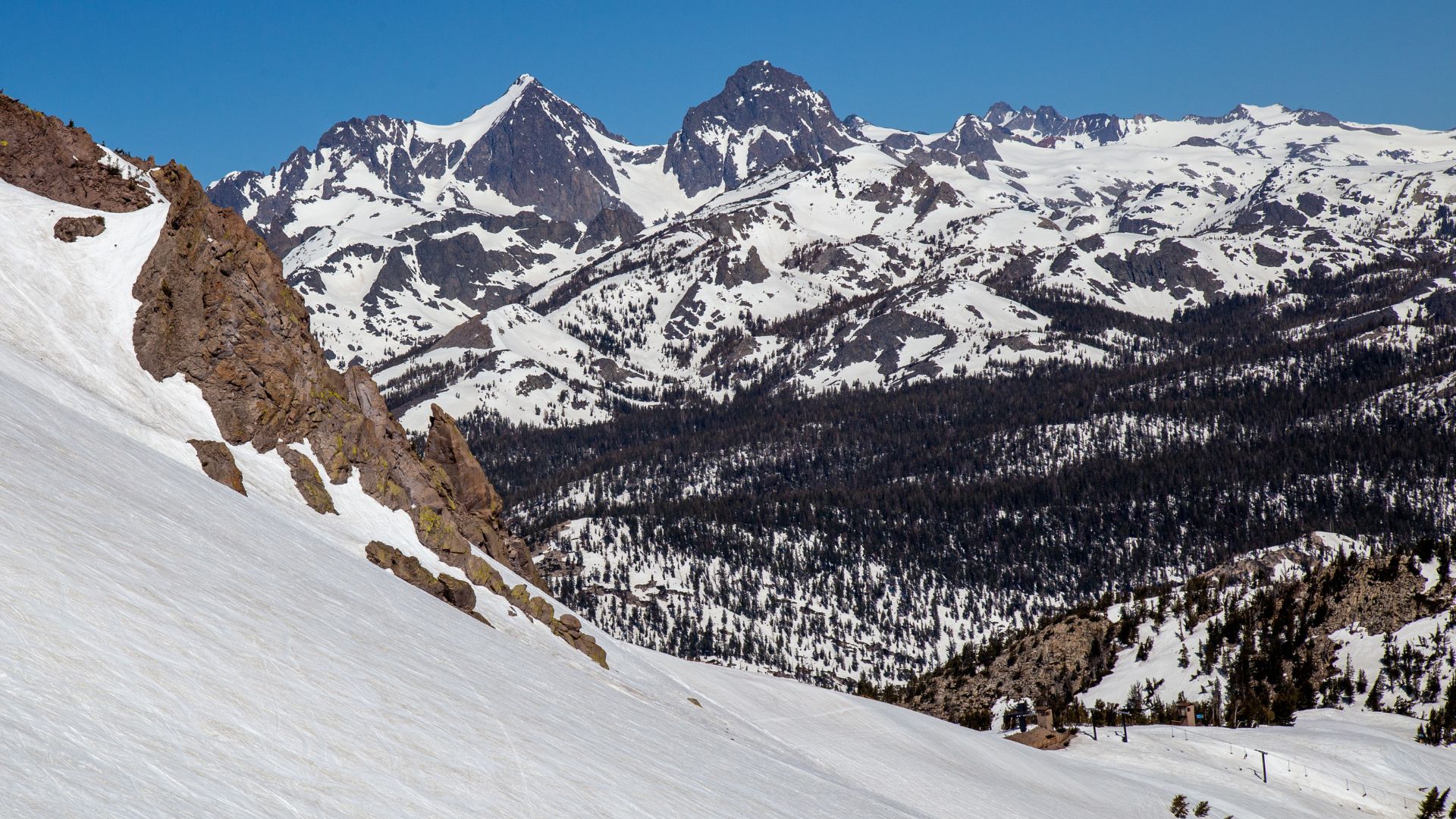
Mammoth Lakes sits out in California’s Eastern Sierra, where ancient volcanic activity left behind some truly dramatic landscapes. Over 100 alpine lakes, massive granite peaks, and all sorts of geological oddities make this a hiker’s dream.
Best Time to Visit for Summer Hiking
In my experience, mid-July through September is prime time for hiking here. Most trails finally shake off their snow by early July, although some of the higher routes hang onto patches of it well into August.
Daytime temps usually hover between 70 and 80°F, dropping to the 40s or 50s at night. That’s pretty comfortable—no desert heatwaves to worry about.
Peak Season Considerations:
- July-August: Trails are open and busy
- September: Cooler, quieter, and sometimes you catch early fall colors
- Early July: Some high trails can still be snowy
Before heading above 10,000 feet early in the season, I’d suggest checking with the Mammoth Lakes ranger station. Snowpack can change things fast.
Geological and Volcanic Features of the Region
You can’t hike around Mammoth Lakes without bumping into its volcanic history—I sure didn’t. Mammoth Mountain looms over everything, a volcanic dome shaped by eruptions over the last 400,000 years.
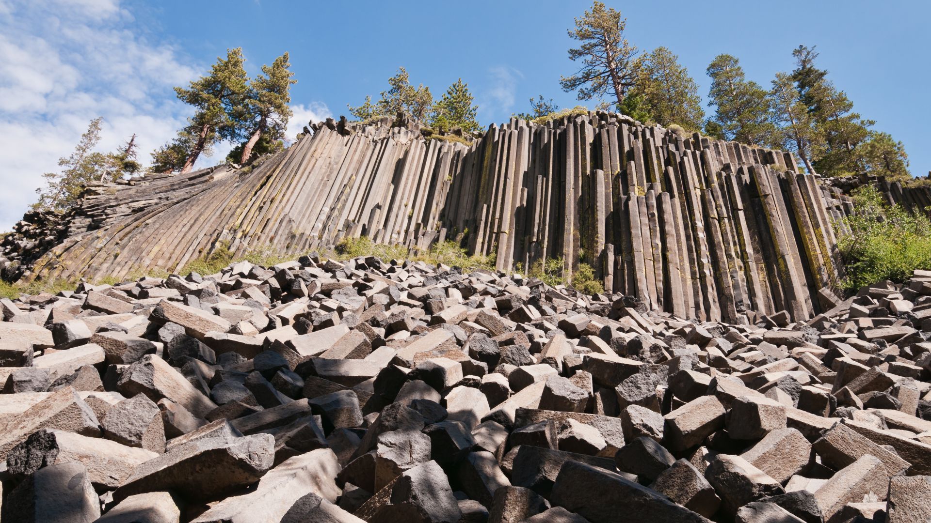
Devils Postpile is probably the most eye-catching volcanic landmark around. Those columnar basalt formations? They look so precise and geometric, it’s almost hard to believe nature made them.
Key Volcanic Features:
- Mammoth Mountain: Active volcanic system
- Basalt columns: Especially at Devils Postpile
- Hot springs: Geothermal spots scattered around
- Obsidian flows: Shiny volcanic glass fields
The region still simmers with geothermal activity. It sits inside the Long Valley Caldera, which last erupted about 760,000 years ago—so, not exactly ancient history in geological terms.
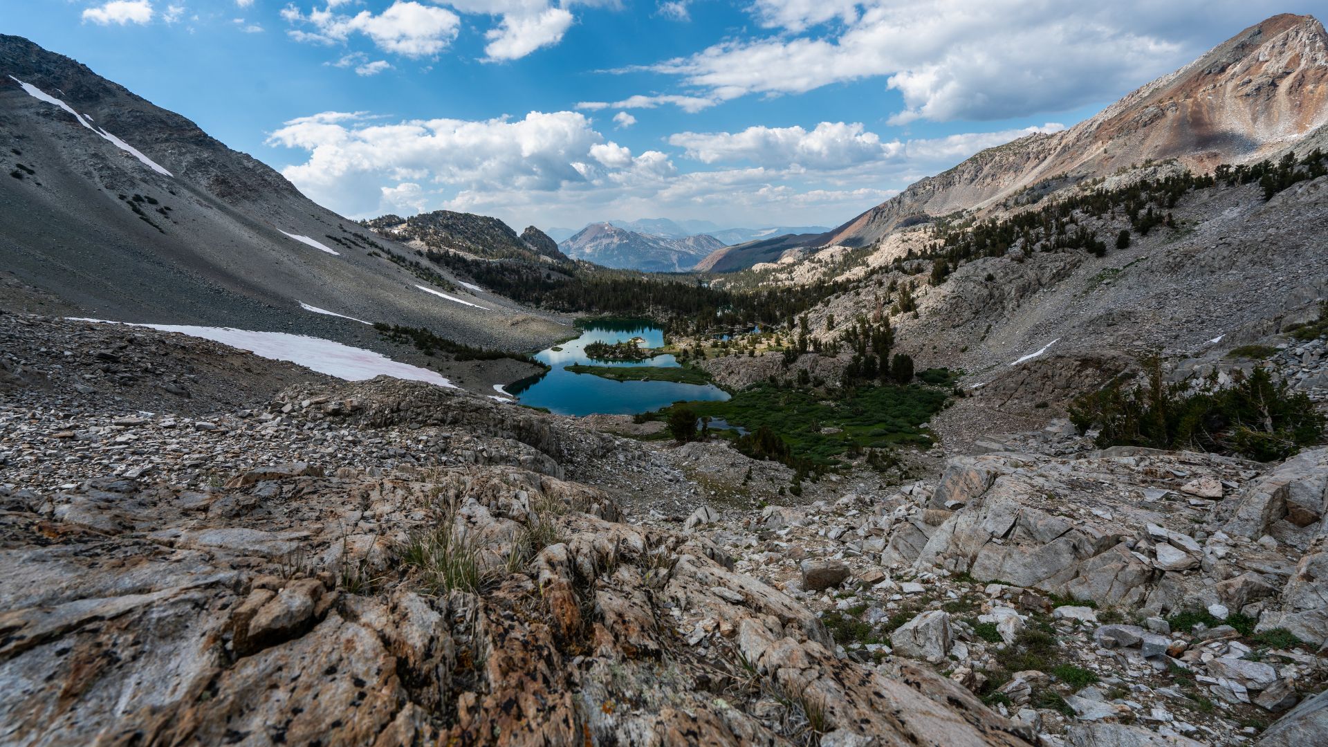
Alpine Lakes and Mountain Scenery
If you love alpine lakes, this place feels like paradise. The Sierra Nevada around Mammoth Lakes is dotted with lakes formed by glaciers, all perched between 8,000 and 11,000 feet.
Most lakes shine with turquoise water, ringed by granite peaks and thick pine woods. The contrast between black volcanic rock and blue water is unreal—makes for killer photos.
Notable Lake Features:
- Thousand Island Lake: 10,000 feet up, Banner Peak in the background
- Convict Lake: Super easy to reach, dramatic mountain reflections
- Duck Lake: Rust-colored peaks, dense pine stands
Even in summer, the lakes stay chilly—rarely warmer than 60°F. Luckily, most are within reach via day hikes (2-8 miles one way), so you can pick your challenge.
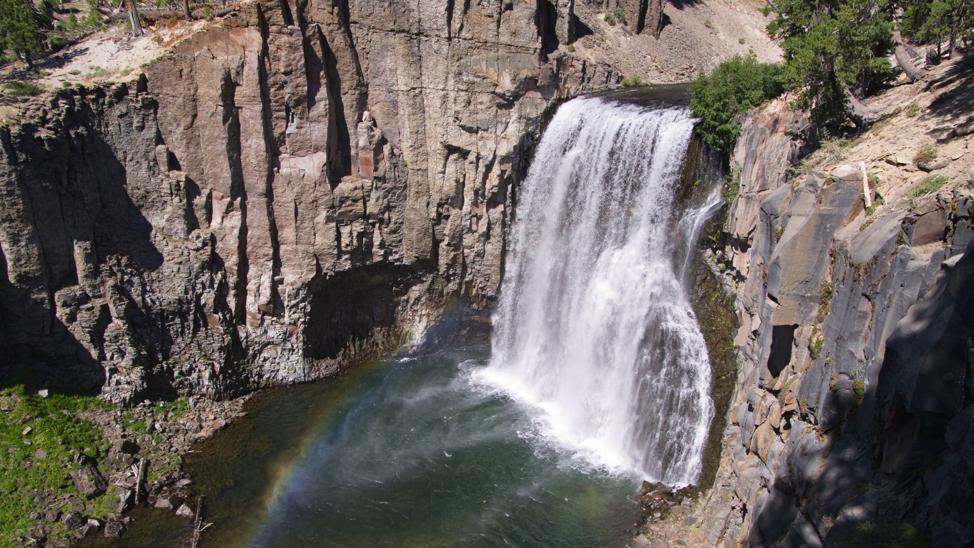
Devils Postpile and Rainbow Falls: Iconic Waterfalls and Volcanic Landmarks
Devils Postpile National Monument really stands out for its volcanic formations and the epic 101-foot Rainbow Falls. You get easy access to those wild basalt columns, plus a moderate hike to one of the most photogenic waterfalls in the Sierra.
Devils Postpile Trail Highlights
The trail to Devils Postpile starts at the ranger station and barely stretches 0.8 miles round trip. I was surprised how quick and easy it was to reach something so cool.
You follow the Middle Fork of the San Joaquin River through shady forest. Signs along the way break down how the postpile formed, which adds a nice touch.
Trail Details:
- Distance: 0.8 miles round trip
- Difficulty: Easy
- Elevation gain: Barely any
- Time: 30-45 minutes
I walked the loop around the base for a close-up look at the columns. If you’re up for a short, steep climb, the trail leads to the top where you can see the polished hexagonal patterns up close.
Rainbow Falls Trail Experience
Rainbow Falls sits about 2.5 miles from the Devils Postpile ranger station. The trail is well-maintained and takes you through meadows, forest, and even areas recovering from old wildfires.
It’s mostly flat, with just a few gentle ups and downs.
What to Expect:
- Distance: 2.6 miles round trip from Rainbow Falls trailhead
- Difficulty: Moderate
- Best viewing: Afternoon (that’s when the rainbows show up)
- Swimming: Pools below the falls are popular for a dip
Afternoons are the best time for catching rainbows in the mist—makes sense, right? There are several platforms for different waterfall angles.
If you take the stairs down to the base, you’ll get hit by a cool spray. In summer, plenty of folks swim in the pool below.
Basalt Columns and Geological History
Devils Postpile formed about 80,000 years ago when a lava flow hit a natural dam and pooled up. As the lava cooled, it fractured into those wild hexagonal columns.
Later, glaciers scraped away layers of sediment and polished the tops of the columns. You can actually see these smooth surfaces if you hike to the top.
Formation Process:
- Lava hits a dam and pools up
- Slow cooling makes hexagonal cracks
- Glaciers later expose and polish the columns
Some columns reach up to 60 feet. The hexagonal shapes are so consistent, it’s almost uncanny.
You don’t see this kind of basalt column very often—maybe in a handful of places worldwide. Here, you can see them both from below and above, which is pretty rare.
The monument links up with the Pacific Crest Trail and sits inside the bigger Reds Meadow area. It’s one of North America’s best spots to see volcanic rock jointing up close.
Crystal Lake Trail: Spectacular Panoramic Views and Alpine Adventure
This 3.2-mile out-and-back trail packs a punch with killer views and about 800 feet of elevation gain. You’ll get sweeping looks at Lake George, Lake Mary, and, if you time it right, a burst of wildflowers in summer.
Trail Route and Elevation Gain
The Crystal Lake Trail starts at the Lake George parking lot in Inyo National Forest. The trailhead is easy to spot, right off Lake George Road.
You’ll climb steadily for the first 1.5 miles, zigzagging up through switchbacks. With 800 feet of elevation gain, it’s a moderate hike—challenging enough to feel earned, but not technical.
The path is mostly dirt with some rocky bits and tree roots. Good shoes help a lot.
Most of the hard work happens early on. The trail flattens out as you get closer to Crystal Lake, winding through shady forest.
Plan on about two hours round trip, including time for photos and soaking in the view.
Lake Overlooks and Surrounding Peaks
About halfway up, the panoramic views start popping up. You’ll catch glimpses of Lake George and Lake Mary through the trees.
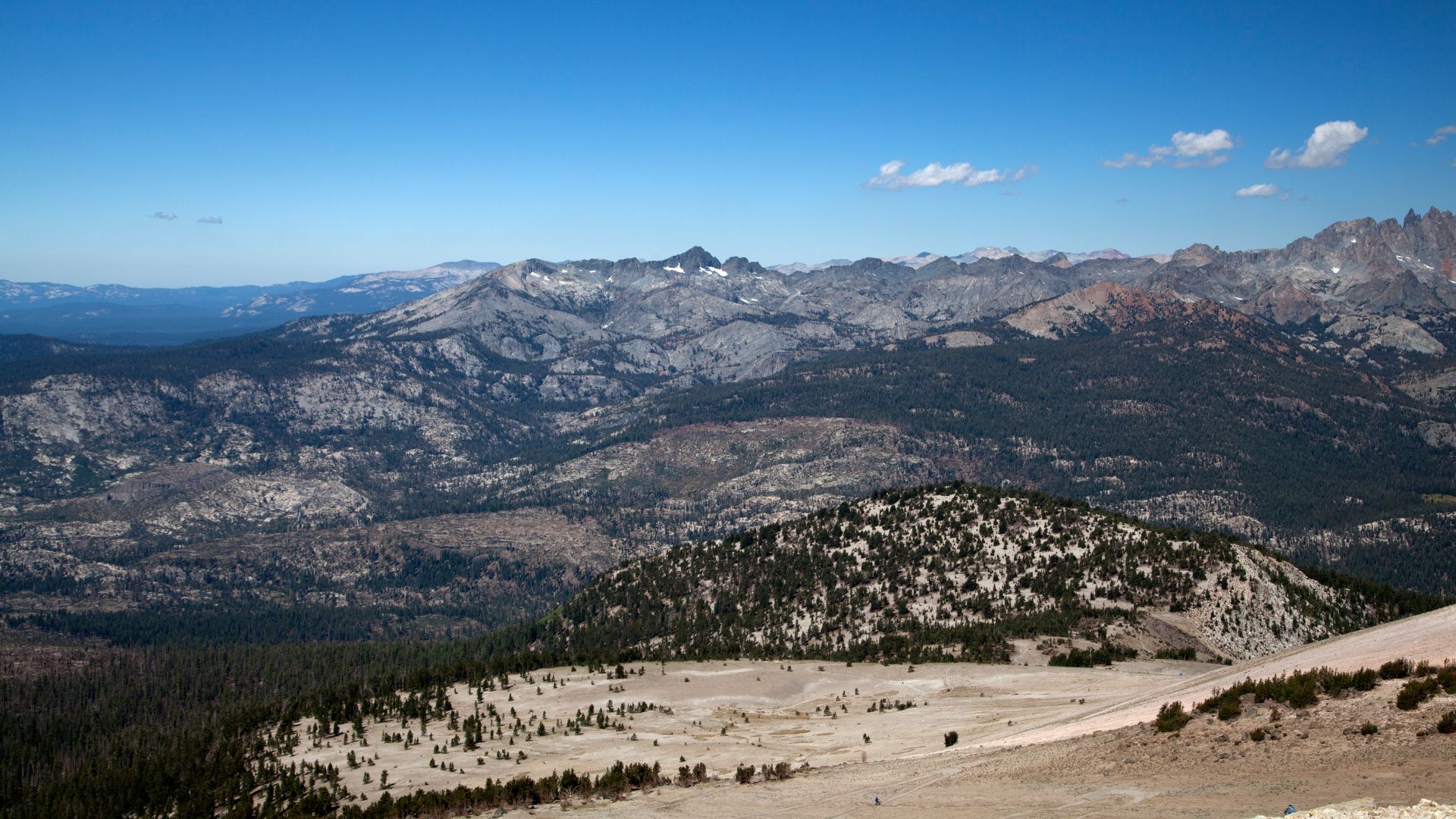
The higher you go, the better it gets. At the top, you can see the whole Mammoth Lakes Basin laid out below.
On a clear day, the Minarets’ spiky peaks stand out in the distance.
Crystal Lake sits right at the base of Crystal Crag, hemmed in by granite cliffs. The turquoise water reflects the mountains—picture-perfect.
From the upper trail, you get a full 360-degree view, including the Mammoth ski area and several 14,000-foot peaks on the horizon.
Wildflowers and Summer Scenery
Summer is prime time for wildflowers along this trail. I saw the best blooms from July into early August.
Lower down, you’ll spot lupine, paintbrush, and mountain aster in bold colors. Higher up, penstemon and mountain pride cover the rocky slopes.
The flowers against the granite make for some awesome photos, especially in the early morning light.
Even in July, the lake water stays pretty cold. But the air is warm and clear, perfect for hiking.
If you want wildflowers, mountain air, and alpine views all in one hike, this is the trail.
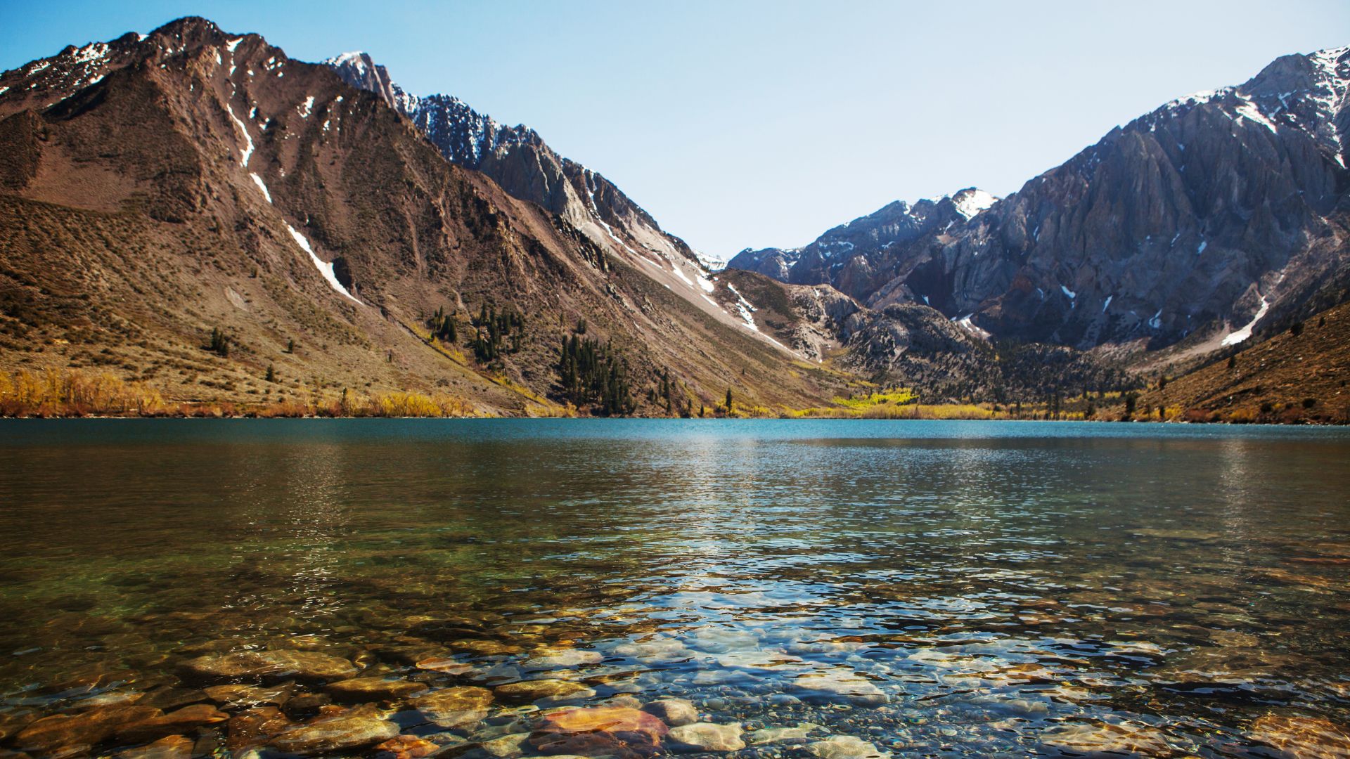
Convict Lake Loop: Scenic Lakeside Hiking and Mountain Vistas
The Convict Lake Loop is a short, sweet 2.5-mile trail that serves up alpine lake views and dramatic mountain backdrops. Convict Lake’s turquoise waters and Mount Morrison’s towering face make it a photographer’s dream.
Convict Lake Loop Trail Guide
Getting there is a breeze—just off Highway 395, south of Mammoth Lakes. The parking lot is next to the marina at the end of Convict Lake Road.
The loop is 2.5 miles with only 180 feet of elevation gain. I walked it in about 90 minutes, stopping plenty for photos.
Trail Features:
- Smooth dirt paths
- A wooden boardwalk over the creek
- Mix of open sagebrush and pine forest
- Beachy spots for taking breaks
The trail stays mostly flat, with just a few gentle hills on the far side. Nothing too tough.
You’ll hit two junctions before the head of the lake—just keep left both times to stay on the main loop. The last stretch is paved and accessible, passing a fishing dock with great lake views.

Views of Mount Morrison and Surrounding Scenery
Mount Morrison absolutely dominates the view, rising straight up from the end of the lake. The granite walls change character as you circle around.
The best photo ops are along the trail’s first half, where the shoreline is open and the mountain looms over the water. Early mornings are especially magical.
Every turn gives you a new angle on the lake and mountains. Looking back toward the outlet, you’ll get a totally different scene.
Notable Scenery:
- Bright turquoise water
- Sheer granite peaks
- Aspen groves (stunning in the fall)
- Wildflower meadows
- Rocky beaches
Pine and aspen trees frame the lake at several spots. The contrast between dark rock and blue water just pops in photos.
Summer Activities and Alpine Lake Atmosphere
Summer rolls in and Convict Lake turns into a lively playground. I watched families casting lines from the shore while kayakers glided across the glassy water.
The beaches here practically beg you to swim or just sprawl out and relax. Even when the sun is high, the water stays brisk—perfect for cooling off after a hike. You’ll find plenty of boulders and old logs to claim as your own little seat.
Summer Activities Available:
- Swimming in alpine waters
- Fishing for trout
- Kayak and paddleboard rentals
- Picnicking on beaches
- Photography
The marina rents out gear and stocks the basics if you forgot something. Convict Lake Resort, just up the road, serves up meals and extra services when the crowds roll in.
Wildlife seems to love summer too. I spotted all kinds of birds swooping around and chipmunks darting through the trees. Even with the popular trail, the whole place feels surprisingly peaceful and untouched.
More Memorable Hikes: Exploring Varied Terrains and Hidden Gems
Mammoth Lakes has so much more than just famous lakes and waterfalls. The trails here wind through everything from volcanic craters to high alpine passes. Some are mellow enough for families, while others push you into full-on mountain adventure mode in the heart of Inyo National Forest.
Sherwin Lakes Trail Experience
Sherwin Lakes Trail really stood out as a favorite moderate hike. It’s about five miles round trip with 880 feet of elevation gain, leading you to two gorgeous alpine lakes.
I started out at the parking area off Sherwin Creek Road on the east side of town. The trail snakes through pine and aspen forests, with switchbacks that never feel too punishing.
Trail Highlights:
- Lower Sherwin Lake: 2.2 miles from trailhead
- Upper Sherwin Lake: Another half mile beyond the first lake
- Views: Sweeping panoramas of the Sherwin Range and Mammoth Crest
Lower Sherwin Lake stopped me in my tracks with its clear water and perfect mountain reflections. Upper Sherwin Lake sits tucked beneath rocky cliffs and towering peaks. Both lakes offer fishing, but the water is icy cold from all that snowmelt.
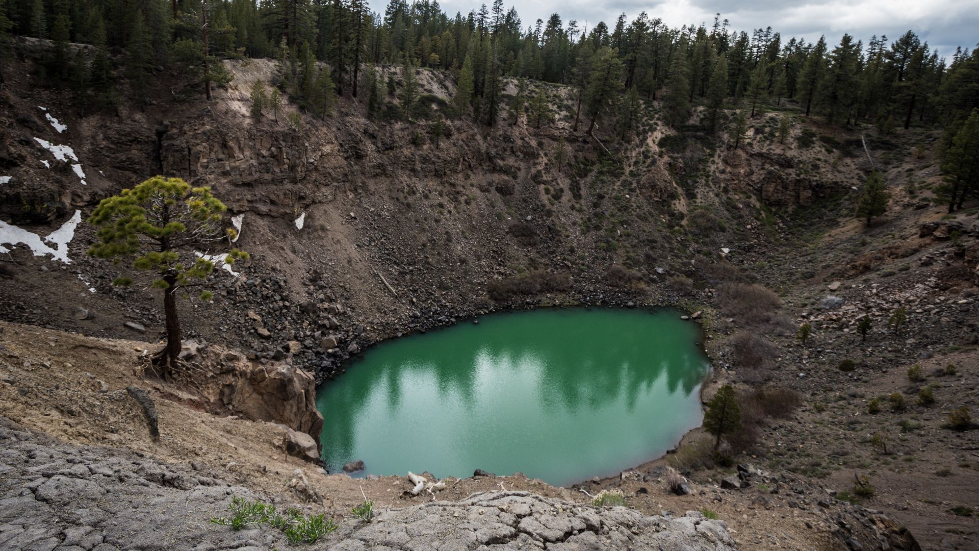
Inyo Craters Trail and Volcanic History
If you want a taste of Mammoth’s wild volcanic side, check out the Inyo Craters Trail. It’s a short 1.5-mile walk, but you get to peer into two dramatic volcanic craters that only formed about 600 years ago.
I found the trailhead off Inyo Craters Road, north of town. The path crosses open ground with big views of the nearby peaks.
Volcanic Features:
- South Crater: Has a small lake inside
- North Crater: Larger, with a more pronounced rim
- Formation: Born from explosive volcanic eruptions
Standing at the rim, I could see the raw power that shaped this land. The hike barely gains any elevation, so almost anyone can enjoy it.
Horseshoe Lake Recreation and Easy Walks
Horseshoe Lake is perfect for an easy stroll—a 1.8-mile loop with barely 100 feet of elevation change. The trail starts at the end of Lake Mary Road.
One thing that caught my eye: all the dead trees along the shore. Turns out, underground volcanic gas (CO2) seeps up and kills them off. It’s a little eerie, honestly, but fascinating.
Safety Notes:
- Stick to marked trails
- Steer clear of gas seep areas
- Pay attention to warning signs
You’ll walk through pine forest and catch some nice mountain views. There’s fishing, picnic spots, and that strange landscape shaped by the earth’s restless energy.
Duck Pass Trail for High Alpine Adventures
Duck Pass Trail is a real challenge—eight miles round trip and a solid 1,000-foot climb. This one leads you deep into the John Muir Wilderness, all the way to Duck Pass and Pika Lake.
I set out from the Coldwater Campground trailhead. The trail climbs through forest, then suddenly breaks open to reveal sweeping alpine scenery.
Key Destinations:
- Pika Lake: Sparkling alpine lake just below the pass
- Duck Pass: High up, with endless views
- Elevation: Over 10,000 feet at the top
Along the way, you’ll pass smaller lakes and find great spots for fishing. Pika Lake hides in a dramatic granite bowl, and the view from Duck Pass stretches for miles across wild, untouched country.
Essential Tips for Summer Hiking in Mammoth Lakes
Hiking here in summer takes a bit of forethought. The trails climb high, the weather can turn on a dime, and parking disappears fast at the most popular trailheads. Above 8,000 feet, afternoon storms are just part of the deal.
Trailhead Access and Parking
I try to hit the trail early—parking lots usually fill up by 8 AM when it’s busy.
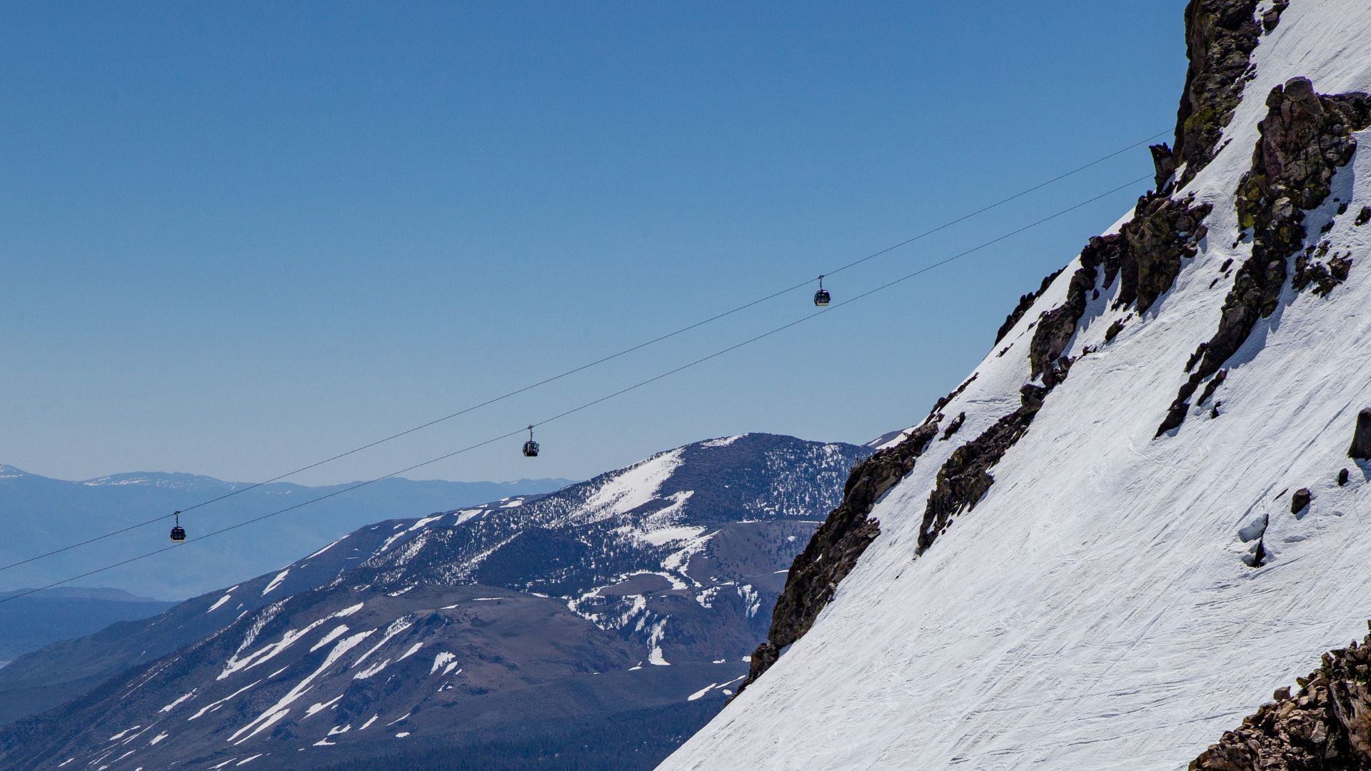
The Lakes Basin Trolley is a lifesaver in summer. It’s free, runs every half hour from the Village at Mammoth, and drops you at all the main trailheads.
If I’m heading to McLeod Lake or nearby trails, I park at Mammoth Mountain Inn and hop on the trolley from there.
Tioga Pass usually opens late May or early June, but I always double-check road conditions before heading toward Yosemite National Park.
Devils Postpile gets crowded, so they only let shuttles on the access road from 7 AM to 7 PM. If you’re driving, plan around that.
Safety, Preparation, and Weather Considerations
Elevation sneaks up on you. Mammoth Lakes itself is at 7,880 feet, and some trails climb above 9,000.
I never leave without these basics:
- Extra water (at least a liter every two hours)
- Warm layers (it cools down 3-5°F for every 1,000 feet you climb)
- Rain jacket (those afternoon storms are no joke)
- Sunscreen and a hat (the sun is brutal up here)
Weather flips fast in the mountains. I check the forecast and hit the trail early to dodge afternoon downpours.
Trail conditions change with the seasons. Snow hangs on north-facing slopes into July some years. I bring snowshoes for early season hikes at higher elevations.
Cell service is spotty at best. I always let someone know where I’m going and when I expect to be back.
Environmental Preservation and Leave No Trace
These mountains get crowded in the summer. I always try to follow Leave No Trace principles to help keep them wild.
Pack out all trash—that means every wrapper, food scrap, even toilet paper. I’ve seen what happens when animals start relying on human food, and it’s not pretty.
I stick to the trails, no matter how tempting that shortcut looks. When people cut switchbacks, they tear up delicate alpine plants, and honestly, those little guys might not recover in my lifetime.
Camp only in designated spots if you’re spending the night. Fires? Usually a no-go in dry months, so I leave the s’mores for another time.
If I bring my dog, I keep her leashed where the rules say so. June Lake and Mammoth are pretty dog-friendly, but keeping wildlife safe matters more.
Water sources? I treat them like treasure. I make sure to camp and wash at least 200 feet away from lakes and streams.
When nature calls, I dig catholes 6-8 inches deep, again at least 200 feet from water. It’s not glamorous, but it’s part of keeping these places beautiful for everyone.