Death Valley National Park overflows with natural wonders that always leave me a little stunned. If you’re chasing the park’s most jaw-dropping landscapes, here’s my personal list of five spots you just can’t skip. Each one reveals a different, unforgettable side of Death Valley—there’s really nowhere else quite like it.
I’ve wandered salt flats that seem to go on forever, climbed wild, technicolor hills that look almost alien, and hiked across sunlit sand dunes that feel otherworldly. Every place on this list has surprised me, and honestly, each visit leaves me a little more in awe. If you’re after sights that stick with you, these are the landscapes to see.
Why Death Valley National Park Is a Landscape Lover’s Dream
Death Valley flips the script on what you’d expect from a desert. I never get tired of the variety—there’s always something new to discover, from wild geology to places shaped by time and weather.
Vastness and Diversity of Desert Landscapes
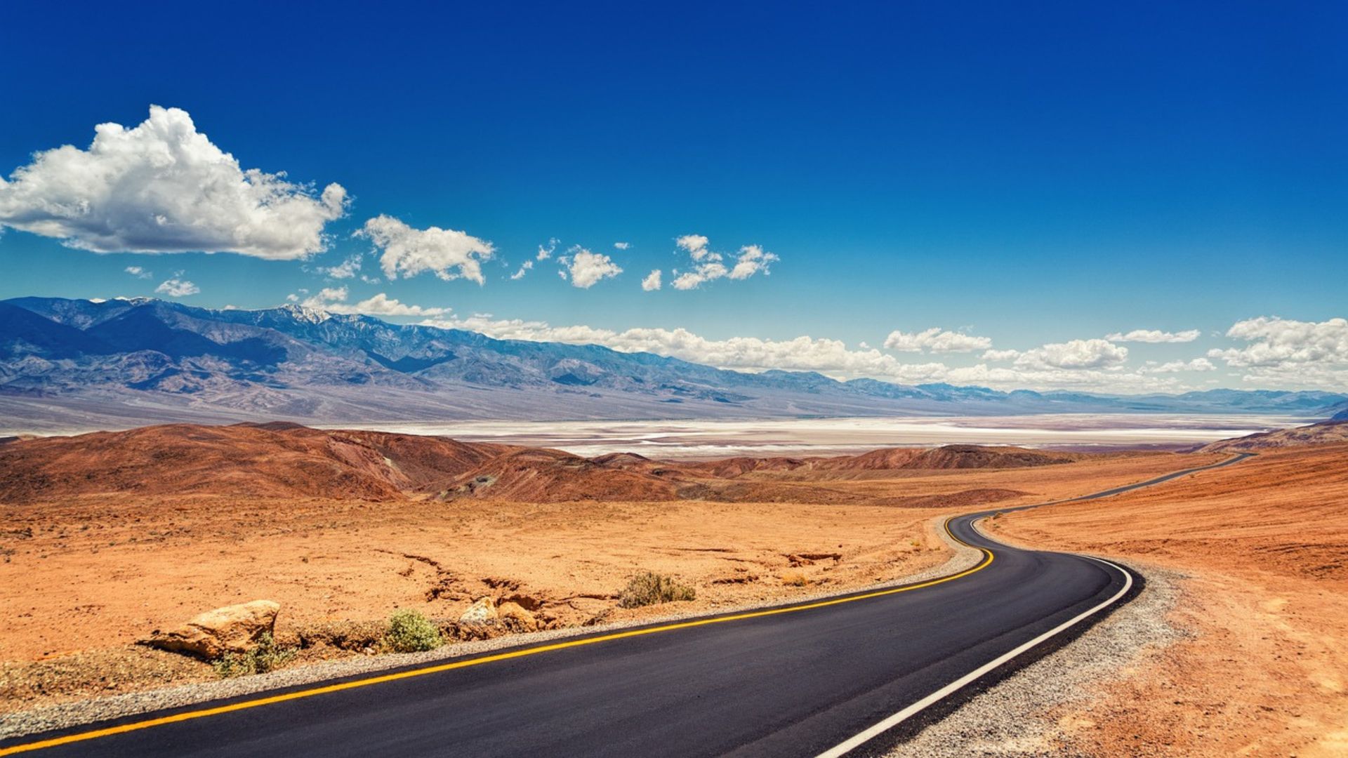
Death Valley is the biggest national park in the lower 48. When I first rolled in, the endless views nearly knocked me over. You’ll find salt flats, sand dunes, rocky canyons, mountains, and even the occasional oasis. That mix makes Death Valley totally different from anywhere else in the Mojave.
The elevation swings are wild—Telescope Peak towers high, while Badwater Basin drops to 282 feet below sea level, the lowest spot in North America.
Each zone supports its own plants and critters. Sometimes, after a rare rain, wildflowers explode across the desert, lighting up the normally muted landscape.
The light here changes everything. At sunrise and sunset, the rocks and sand glow with deep, shifting colors. The night sky is so dark that stargazing feels almost unreal.
Standout Natural Wonders
Some spots in Death Valley keep pulling me back. Badwater Basin’s salt flats look like a white ocean, stretching out forever. Mesquite Flat Sand Dunes rise in big, rolling waves, easy to reach and always fun to explore.
Dante’s View sits high above the valley, letting me see for what feels like forever. Ubehebe Crater is a massive volcanic scar, a reminder of the raw power underfoot. Zabriskie Point’s colorful badlands are especially striking when the light hits just right. Each spot has its own vibe and beauty.
Unique Geology and Landforms
Death Valley’s geology stands out everywhere I look. Layers of stone tell stories of ancient seas and shifting earth. Jagged mountains, deep canyons, mud hills, and those endless salt flats all show off nature’s handiwork.
I’ve watched erosion and earthquakes carve out places like Golden Canyon and Mosaic Canyon, where narrow passages and polished walls draw your eye. At Badwater, salt polygons form from cycles of water and sun. It’s a wild, ever-changing mix of colors and shapes.
Special wildlife calls these landforms home. Even in the heat, I’ve spotted rare fish in springs and watched hardy animals dart between rocks. The blend of geology and life keeps Death Valley feeling fresh every time I visit.
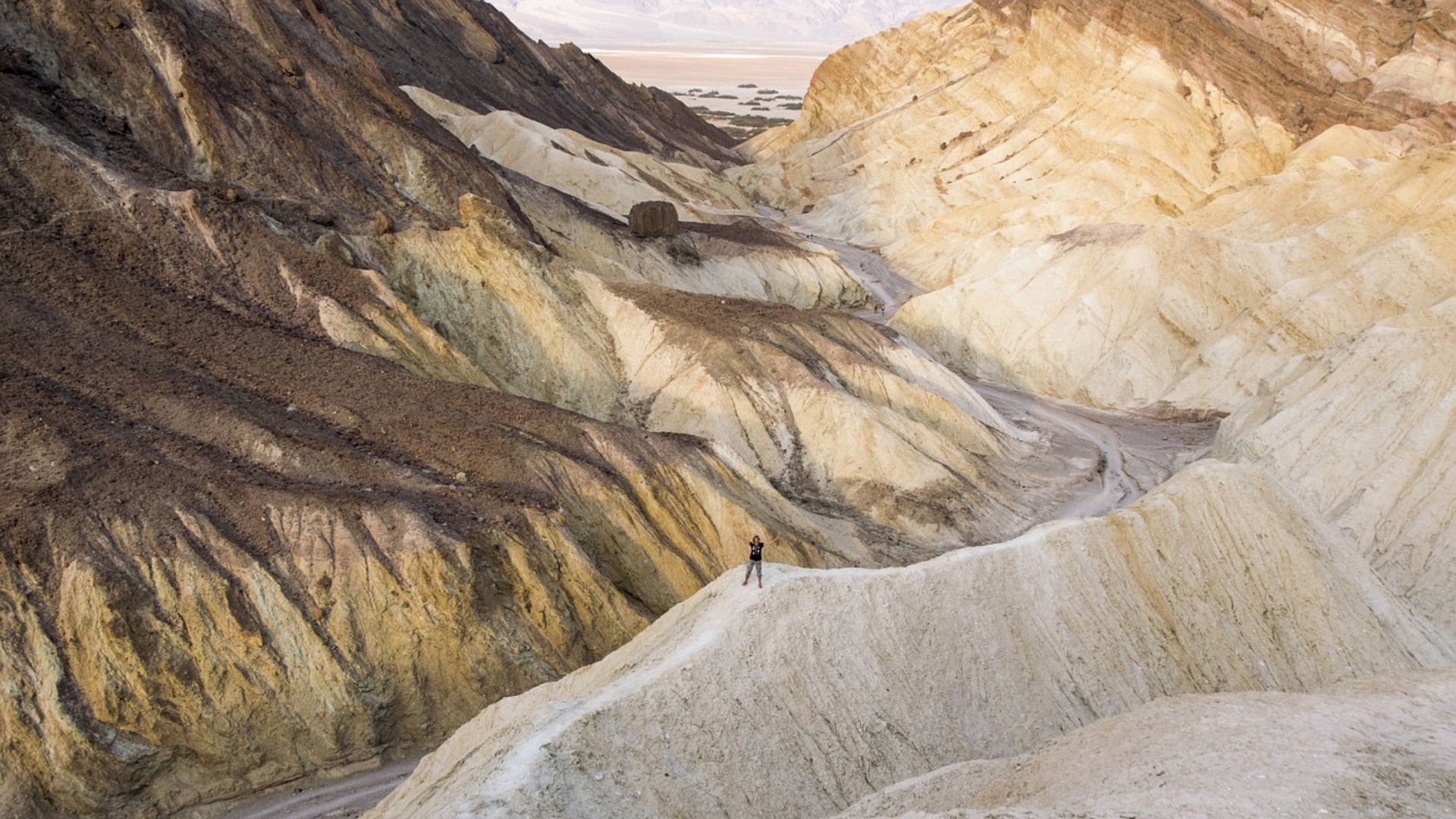
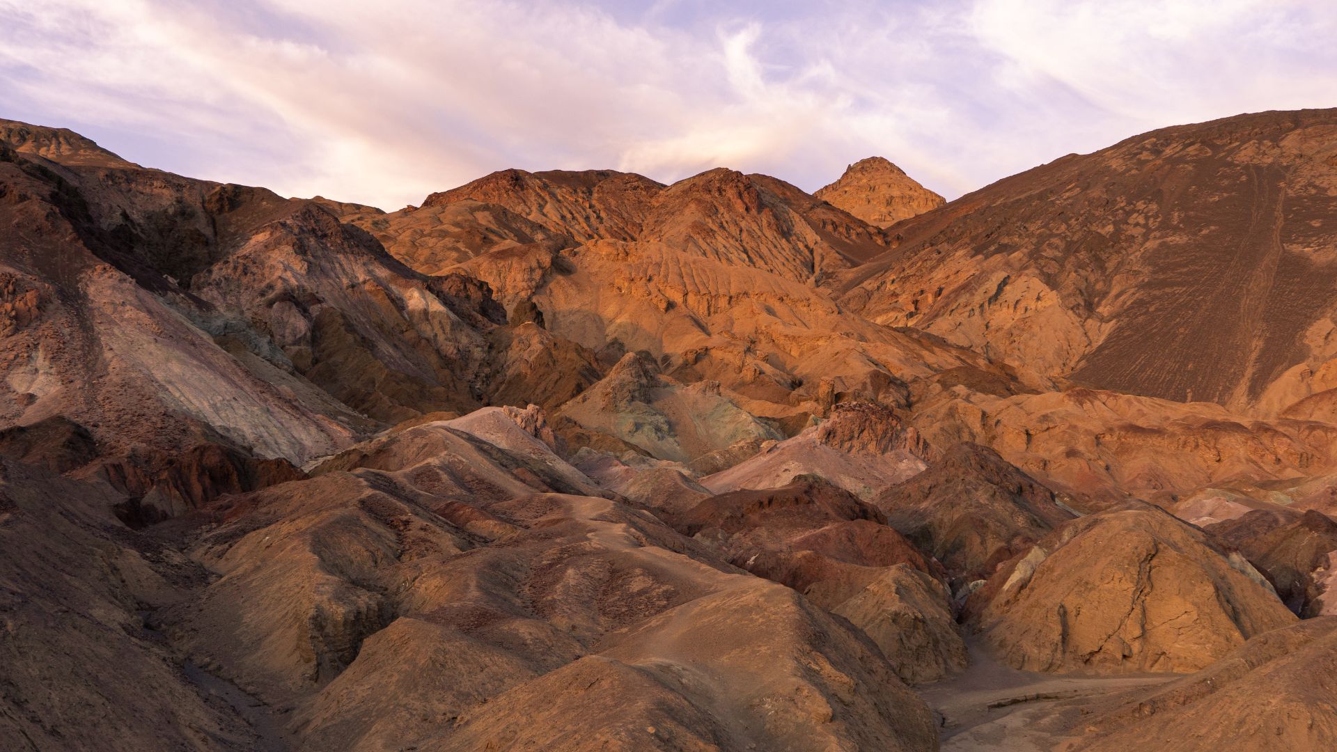
Zabriskie Point: Surreal Badlands and Sunrise Views
Zabriskie Point never fails to impress—it’s one of the most dramatic, photogenic places in Death Valley. Famous for its eroded hills, sweeping viewpoints, and easy access, it’s an absolute must for anyone who loves wild scenery or photography.
Sweeping Panoramic Views
The first thing I notice at Zabriskie Point is the view—those wild, colorful badlands look like they belong on another planet. Yellows, browns, and golds swirl in layers, shaped by centuries of wind and rain.
From the main overlook, I can see tight ridges and twisting gullies stretching out for miles. The Amargosa Mountains rise in the distance, making every photo feel epic. The viewpoint sits just five miles from Furnace Creek, so it’s a breeze to reach by car.
A paved path leads up from the parking lot, so most people can get there easily. Benches let you sit and just take it all in. Along the way, signs share quirky facts about the area’s mining history and geology.

Golden Hour and Photography Tips
Sunrise at Zabriskie Point is magic—honestly, the colors and shadows feel unreal. I always aim to arrive at least half an hour before the sun comes up.
For photos, I grab a wide-angle lens to capture those sweeping hills. The golden hour right after sunrise brings soft light and long shadows, perfect for showing off details in the rock. A tripod helps if you’re shooting before the sun’s fully up.
Clouds add drama, so I cross my fingers for a partly cloudy morning. At sunset, the hills cool down in color, but the views are still gorgeous.

Badlands Loop and Gower Gulch
If I want to get closer, I hike the Badlands Loop Trail starting right at Zabriskie’s parking lot. The 2.7-mile loop connects to Gower Gulch, letting me wander deeper into the twisted landscape.
Along the trail, I walk through washes and rolling hills, up close with the striped rocks. There’s almost no shade, so I always carry water and wear a hat—midday heat here is no joke.
The Gower Gulch extension adds a bit more distance and winds through a narrow canyon. It offers new views back toward Zabriskie and the wild geology that makes this spot stand out. For me, it’s the best way to really feel the landscape.
The Mesquite Flat Sand Dunes: Iconic Desert Experience
The Mesquite Flat Sand Dunes, just outside Stovepipe Wells, are classic Death Valley. Their sweeping curves, endless sand, and surprising details give a real taste of the park’s desert magic.
Dune Formations and Landscape Features
When I wander the Mesquite Flat Sand Dunes, I’m struck by how far the ridges stretch—waves of sand rolling across the valley floor. The tallest dune climbs about 100 feet, but most are smaller and easy to explore. In the afternoon, the sand feels warm underfoot, almost soothing.
Different types of dunes mix together here—crescent-shaped barchans, star dunes, and more. Wind constantly reshapes them, blowing sand in from the flats. Mesquite trees pop up in clusters, their roots holding the sand and adding a splash of green. It’s wild how these trees thrive with so little water.
Morning and evening light transforms the dunes, casting sharp shadows and deepening the golds and reds. Photographers love it here, but honestly, anyone can appreciate the quiet beauty at sunrise or sunset. The views of distant mountains just add to the vibe.
Sandboarding and Adventurous Activities
Smooth slopes and gentle curves make these dunes perfect for sandboarding. I’ve seen folks bring boards or sleds and zip down the bigger hills. Climbing back up, though? That’s a workout, especially in the heat.
There aren’t any marked trails, so I just pick a direction and wander. Lots of people trek out to the tallest dune, which takes about an hour round trip. The sand heats up fast, so I pack water and try to avoid the midday sun.
At night, the dunes become an awesome spot for stargazing. With no city lights, the stars pop out like nowhere else. Sometimes I’ll see people with telescopes or just lying back to catch a meteor shower.
Wildlife and Natural Phenomena
Even here, if I’m patient, I spot wildlife darting across the sand. Lizards and beetles leave tiny tracks, perfectly adapted to this tough environment.
During cooler mornings or in winter, I sometimes catch sight of kangaroo rats or jackrabbits. They hide from the heat, coming out at dusk or dawn.
Around the mesquite trees, life clusters—birds perch in the branches, chasing insects and shade. After a rare rain, wildflowers sometimes bloom at the base of the dunes, drawing bees and butterflies. The landscape changes fast after a storm, so every visit feels a little different.
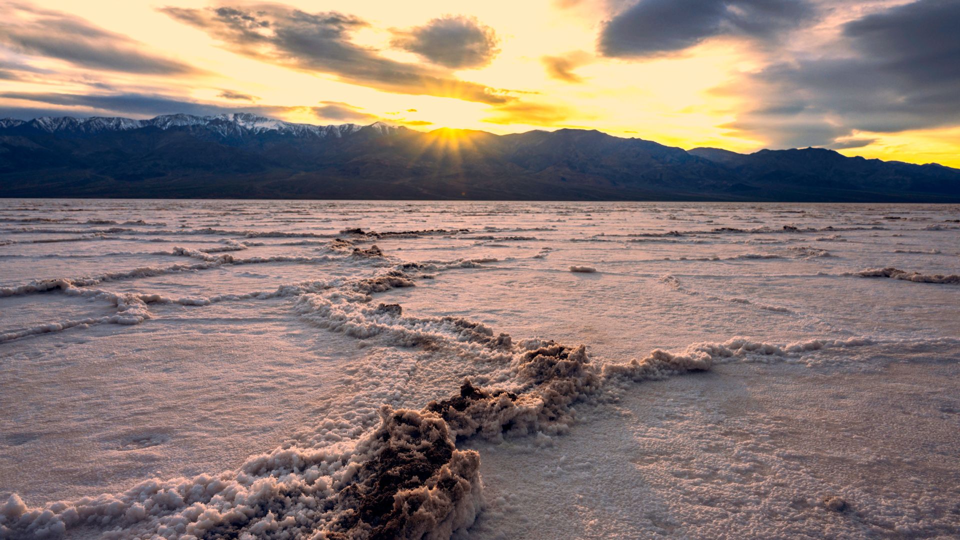
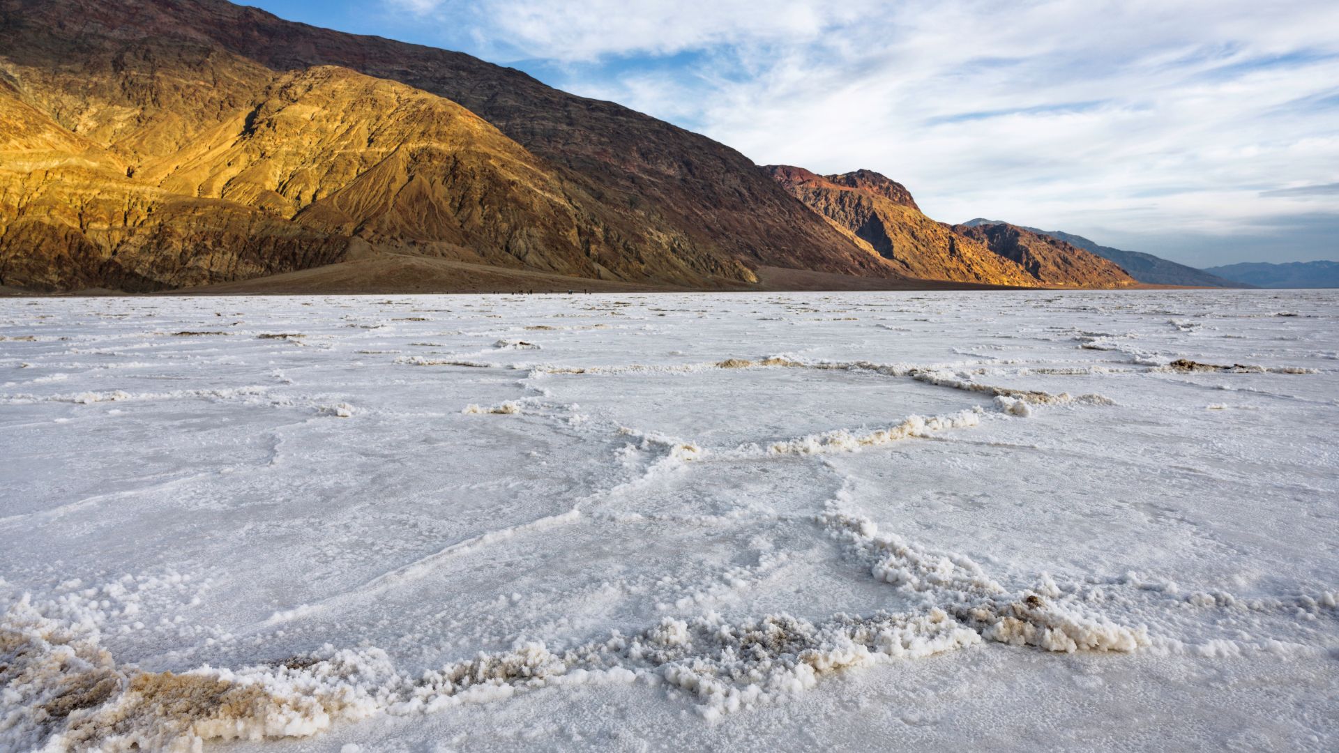
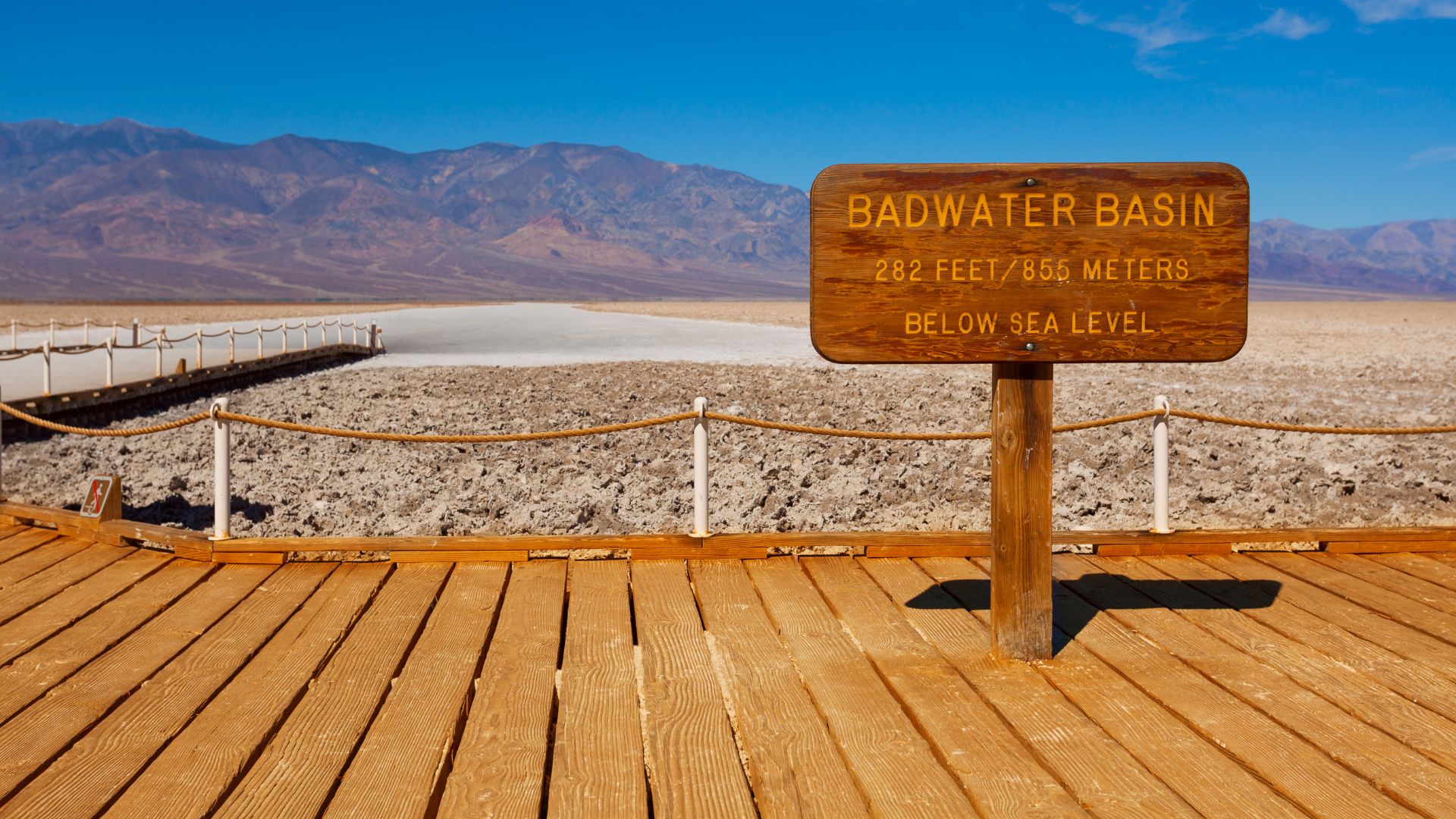
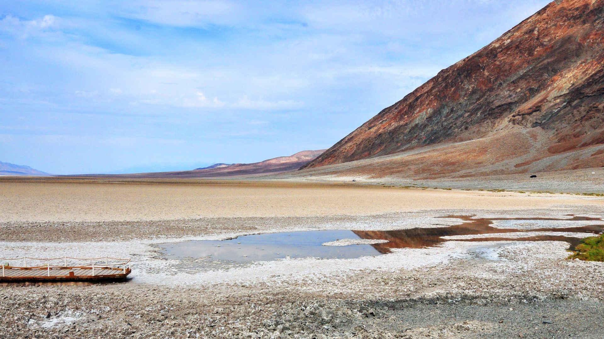
Badwater Basin: The Lowest Point in North America
Badwater Basin is something else—salt, sun, and time have made it unforgettable. Sitting at 282 feet (86 meters) below sea level, it’s a place where extreme conditions create sights you won’t find anywhere else.
Salt Flats and Stunning Vistas
The first time I set foot in Badwater Basin, the endless white salt flats blew me away. The ground looks like snow, but it’s crunchy and hot underfoot. Salt crusts stretch for nearly 200 square miles, making this one of the biggest protected salt flats on Earth.
Patterns in the salt form from cycles of rain, evaporation, and crystal growth. Polygons spread out as far as I can see, each one unique. The colors shift through the day—sunrise and sunset bring soft pinks, golds, and purples.
From here, Telescope Peak rises in the distance, nearly two miles above the basin. That contrast between the lowest and highest points is something I haven’t seen anywhere else.
Understanding the Extreme Environment
Badwater Basin is notorious for heat and dryness. It’s not just the lowest point in North America—it’s also one of the hottest spots on the planet. In summer, ground temps can easily top 120°F (49°C). The sun bounces off the salt, making it feel even hotter.
Most of the time, the basin is bone dry, but after rare rains, shallow pools form for a little while. As they evaporate, fresh salt crystals appear. I’ve seen signs warning visitors not to drink the salty water—good advice, honestly.
Only the toughest plants and animals survive out here. Most wildlife sticks to the edges, where there’s a bit more shelter.
Tips for Visiting Safely
If you want to explore Badwater Basin, staying safe is key. I always bring at least a quart (about a liter) of water per person—there’s no drinking water at the basin itself.
A wide-brimmed hat, sunscreen, and sunglasses are must-haves, since the glare can be brutal. Early morning or evening is the best time to visit—less heat, better photos. Good shoes help on the rough salt crust.
I stick to marked paths to protect the fragile surface and avoid getting lost. Cell service is spotty, so I let someone know my plans before heading out. Following posted warnings and park rules just makes sense.
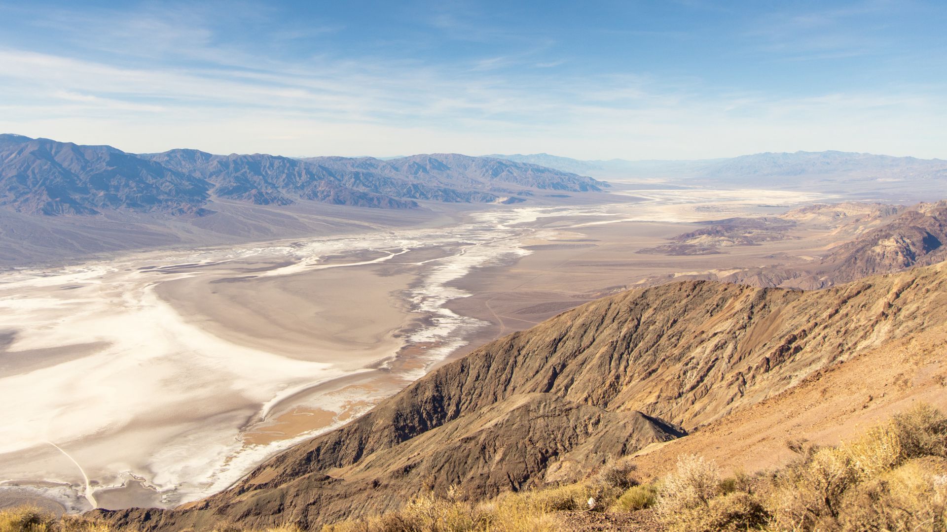
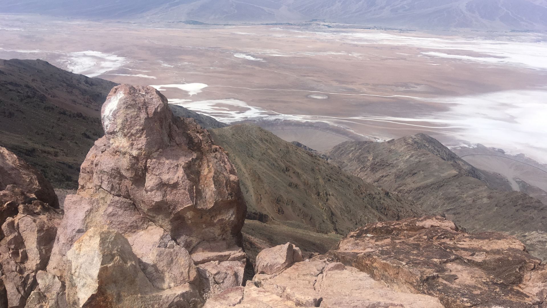
Dante’s View: The Ultimate Panoramic Overlook
Dante’s View rises high above Death Valley, offering some of the wildest views in the park. From up here, I can see both the lowest and some of the highest points in the lower 48 all at once.
The Overlook and What You Can See
Dante’s View sits way up at about 5,476 feet above sea level, right on the crest of the Black Mountains. When I arrive at the viewpoint, I can look straight down at Badwater Basin—282 feet below sea level and honestly, it’s wild to think that’s the lowest spot in North America.
From up here, the salt flats twist and turn like a winding white river. On a really clear day, I might even spot Mount Whitney far off to the northwest. That’s the tallest point in the lower 48, soaring up to 14,505 feet.
So, in just one sweep of my eyes, I catch the greatest elevation difference in the whole country. It’s a bit mind-boggling.
The landscape stretches endlessly. I see colorful hills, jagged ridges, and those flat, endless valley floors.
Clouds rush by at this height, and the shifting light and shadows keep the valley below in constant motion.
Best Conditions for Visiting
I always get the best views from Dante’s View on crisp, clear mornings. Early mornings usually bring cooler air and sharp, detailed scenery—especially from late fall to early spring when that annoying heat haze stays away.
Midday? I usually skip it. The light gets harsh and flat, and the magic kind of disappears. Sunrise and sunset are the real showstoppers, though. Long shadows stretch across the valley, and the salt flats glow gold and pink. I always check the weather before heading up—dust or low clouds can totally block the views.
Don’t let the heat in the valley fool you. Up here, it can turn windy and surprisingly cold, so I always toss a jacket in my bag. Spring and late autumn feel just right to me. Even summer can be chilly at this elevation, and winter sometimes brings a dusting of snow.
Connecting to Telescope Peak and the Sierra Nevada Mountains
One thing I love about Dante’s View? That unbeatable sightline to Telescope Peak and, if the sky’s clear, the distant Sierra Nevada range. Telescope Peak stands across the valley, almost 11,049 feet high, and when it’s got a cap of snow in winter or spring, it really pops.
If I look west, I can trace the outline of the Sierra Nevada Mountains. Sometimes, if I’m lucky, I’ll pick out the shape of Mount Whitney. It’s a cool reminder of how Death Valley sits among California’s highest peaks.
There aren’t any direct hiking trails from Dante’s View to Telescope Peak. Their connection is all about the view across the valley. The scale of the park hits you here, and it’s hard not to feel a bit small in the best possible way.
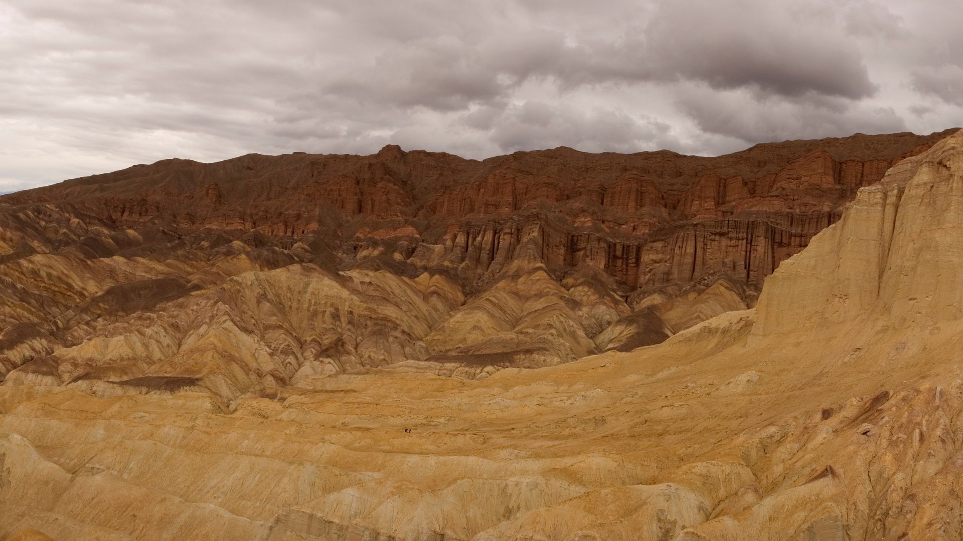
Artist’s Palette and Golden Canyon: Vibrant Colors and Dramatic Trails
Death Valley’s geology is just wild—bands of color, sharp rock formations, and tight passageways. I never get tired of exploring these spots on foot, and they’re always a treat for the eyes.
Exploring Artist’s Palette
Pulling up to Artist’s Palette, I always feel like I’ve stumbled into a painter’s workshop. The hills are streaked with pink, green, purple, and gold—almost unreal. Those colors come from minerals in the rocks, all baked and transformed by the desert’s heat.
I always take the one-way Artist Drive, which winds through the hills for about 9 miles. There are a few pull-offs, but the main event is the Artist’s Palette parking area.
Late afternoon or sunset is when this place really comes alive. The colors get bold and almost electric. A short walk from the parking lot gets me closer to the rock formations. The breeze is usually gentle, and it’s perfect for snapping photos or just soaking it all in.
Tips:
- Length of drive: 9 miles (one-way)
- Best light: Late afternoon to sunset
- Parking: Available at Artist’s Palette viewpoint
Golden Canyon Trail and Red Cathedral
Golden Canyon is hands-down one of my favorite trails in Death Valley. The canyon walls glow with gold and orange, and the trail itself is clear and easy to follow. I always start at the Golden Canyon parking lot, just off Badwater Road.
The main trail is roughly 2 miles roundtrip, leading right up to the Red Cathedral. This towering formation has deep red walls and sharp spires that look almost otherworldly. If I’m in the mood for more, I’ll keep going past the Red Cathedral up a rocky path for even better valley views.
Water is a must—there’s almost no shade out here. I usually finish in about 1.5 hours, depending on how many times I stop for photos. And honestly, I stop a lot.
Trail key points:
- Trailhead: Golden Canyon parking off Badwater Road
- Length: 2 miles round trip to Red Cathedral
- Difficulty: Easy to moderate
- Best time: Early morning or late afternoon
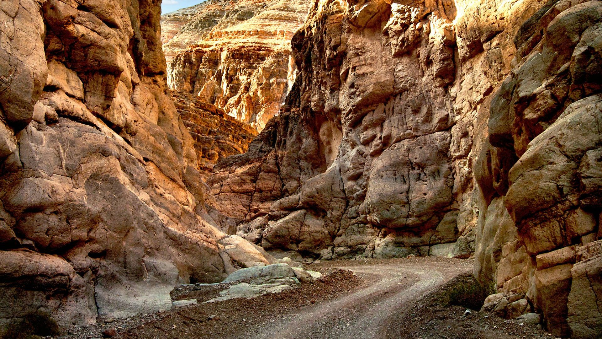
Mosaic Canyon and Slot Canyon Adventures
Mosaic Canyon always surprises me with its striking, narrow passageways. You walk in through a wide entrance, but it quickly squeezes down into these polished marble walls with wild, mosaic-like stone patterns.
I keep an eye on my footing here, especially if it’s rained recently. The first half mile feels pretty easy—smooth rock, gentle walking.
Then the canyon walls start twisting around, forming hidden passageways that almost feel secret. Sometimes I have to turn sideways and squeeze through, just enough space for one person at a time. That’s the real magic of a slot canyon.
Usually, I’ll hike as far as feels right, maybe up to 2 miles each way. The trail gets rougher, but honestly, the changing colors and wild rock textures keep me curious.
Quick facts:
- Trailhead: Mosaic Canyon Road, near Stovepipe Wells
- Length: Up to 4 miles round trip (go at your own pace)
- Highlights: Slot canyon narrows and patterned rock walls