Most folks end up stuck on Yosemite Valley’s busy main roads, missing out on some of the High Sierra’s jaw-dropping drives. Over the years, I’ve wandered California’s mountain highways and stumbled onto some routes that are honestly way more peaceful and, in my opinion, even more beautiful—think granite peaks, sparkling alpine lakes, and forests that feel like ancient cathedrals.
These five scenic drives let you soak in the High Sierra’s secret beauty. I’m talking about lesser-known passes and backcountry roads where the views are huge and the crowds are tiny.
Each drive gives you a different slice of the mountains—maybe it’s a sweeping overlook, a quiet lakeside cruise, or a gateway into untouched wilderness.
I picked these based on how stunning they are, how easy it is to get there, and how well they capture the Sierra’s wild side.
Some cross the highest passes, others wind through valleys where you’ll barely see another car. If you love mountain driving, this region really is California’s best-kept secret.
Criteria for Selecting the Most Scenic High Sierra Drives
The best High Sierra drives? They’ve got to have those epic mountain views, fewer people, and be open most of the year.
I always look for routes that mix up the scenery and stay mindful of seasonal closures.
What Defines a Scenic Drive in the High Sierra
For me, the top drives show off the Sierra Nevada’s wild granite and those blue-green alpine lakes.
Elevation changes are key—you get new ecosystems and surprises around every bend.
Mountain Views always top my list. I’m drawn to roads with clear views of peaks over 10,000 feet.
Yosemite-area routes have those classic domes and icy summits.
Water Features make a drive memorable. If a road skirts a lake, river, or waterfall, I’m probably pulling over for a photo.
Forest Diversity adds to the magic. I love drives that shift from oak woodlands up into pine or even giant sequoia groves.
Crowd Levels can make or break a trip. I avoid the packed areas and hunt for those quiet, lesser-known roads. The High Sierra’s full of them if you know where to look.

Best Seasons and Weather Considerations
Spring (April-May) brings wildflowers, but snow blocks the high passes.
I stick to under 6,000 feet until things melt out.
Summer (June-September) is prime time—most passes open by late June.
Weekdays are less crowded, so I try to plan around that.
Fall (October-November) is underrated. Aspen leaves go gold and crowds thin out, but weather turns fast after October.
Winter (December-March) shuts down a lot of roads. I stay lower, sticking to what’s still open.
| Season | Best Elevation Range | Road Conditions | Crowds |
|---|---|---|---|
| Spring | Below 6,000 ft | Snow above 7,000 ft | Moderate |
| Summer | All elevations | Generally clear | High |
| Fall | Below 9,000 ft | Early snow possible | Low |
| Winter | Below 5,000 ft | Chains required | Very low |
Permits, Reservations, and Park Regulations
Yosemite Region asks for day-use reservations in peak season.
I book online early—May through September fills up fast.
National Forest Roads are way easier—no permits for just driving, and you can improvise your route.
Some parking areas still fill up, though.
Campground Reservations are a must for the popular spots.
I use Recreation.gov for national parks and forests, but private campgrounds can be more flexible.
Vehicle Restrictions pop up on narrow byways. Big RVs can’t always make those tight turns.
I always double-check road widths and grades before heading out.
Fire Restrictions sometimes close roads during dry spells.
I keep an eye on park websites for red flag warnings or sudden closures.
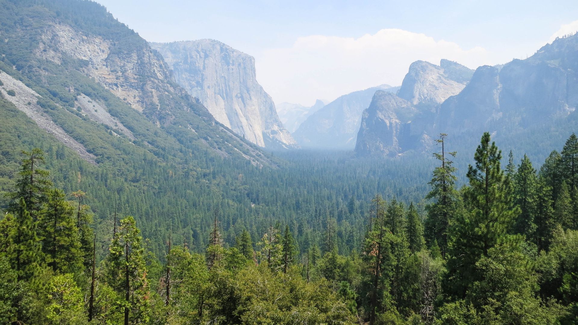
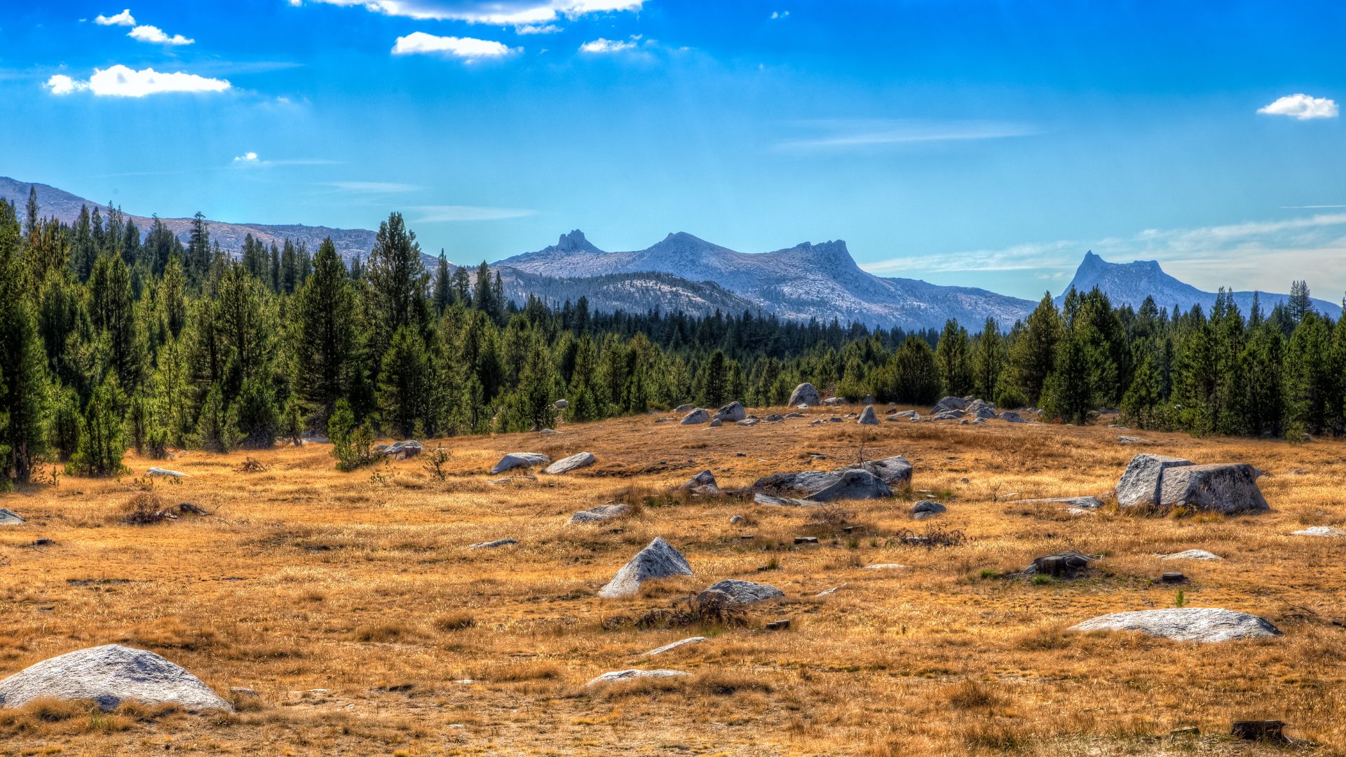
Tioga Road and Pass: Gateway to Yosemite’s Alpine Wonders
Tioga Road winds for 47 miles through Yosemite’s high country, topping out at a wild 9,945 feet. It’s actually the highest highway pass in California.
This drive links granite domes, sprawling meadows, and jewel-like lakes, all while opening up the Eastern Sierra.
Highlights: Tuolumne Meadows, Tenaya Lake, Olmsted Point
Tuolumne Meadows sits at 8,600 feet and, honestly, feels like the heart of Tioga Road.
I love wandering the easy trails along the Tuolumne River or the Soda Springs Trail.
It’s just 1.6 miles roundtrip and barely climbs, so you can really soak in the scenery.
In summer, wildflowers explode across the meadows.
Tenaya Lake is one of the easiest alpine lakes to reach.
It’s ringed by smooth granite and sits at 8,150 feet, with plenty of pullouts for parking.
The Tenaya Lake Trail hugs the shore for about 3.4 miles roundtrip—no road noise, just mountain reflections.
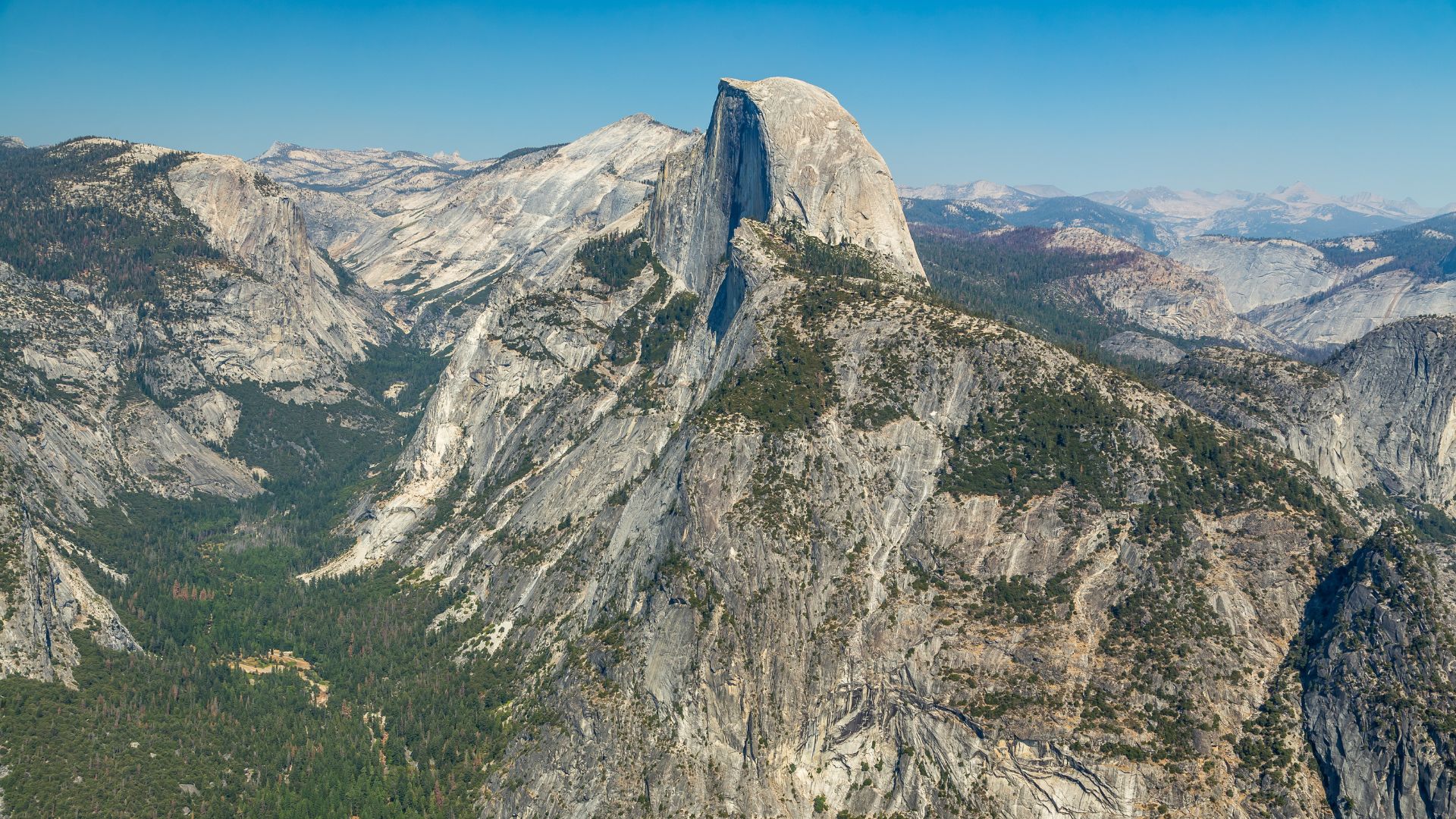
Olmsted Point is the spot for a wild view of Half Dome’s backside.
You don’t need to hike; just park and take it all in.
The granite here is polished smooth by ancient glaciers—a real reminder of the Sierra’s icy past.
Navigating Tioga Pass: Tips for Travelers
Tioga Road usually opens in late May and closes by November. Snow can change things fast.
I always check conditions right before heading up.
Here’s what I always do:
- Fill up on gas at Crane Flat—there’s nothing up high
- Pack extra water, since the altitude can sneak up on you
- Plan for slow speeds (35-45 mph) and lots of curves
- Use the turnouts—locals and speedsters will thank you
Steep drop-offs and rockfall zones keep me on my toes. I try to stay focused and avoid distractions.
Tuolumne Grove is my go-to for giant sequoias without the crowds.
It’s a 2-mile roundtrip hike (paved, but 400 feet down and back up).
Services are sparse along Tioga Road. Only Tuolumne Meadows has basics, and that’s just in summer.
Side Trips: Mono Lake and Lee Vining
Lee Vining sits at the eastern end of Tioga Road (6,837 feet). It’s tiny but has gas, food, and a laid-back vibe.
I always stop at Whoa Nellie Deli—yes, it’s in a gas station, but the food is surprisingly great after a day on the road.
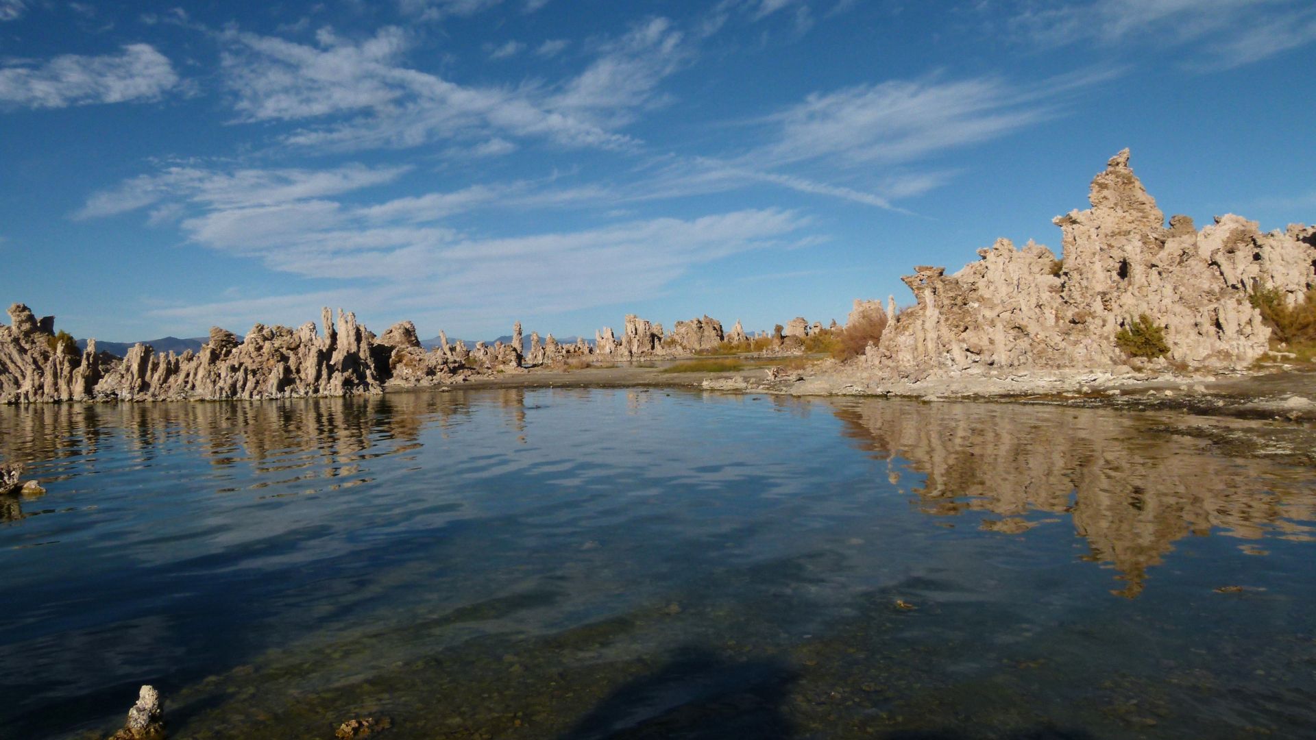
Mono Lake is just minutes away and looks like another planet.
Those tufa towers are wild—formed by underwater springs over centuries.
The South Tufa Area is a must for photos, and the boardwalk trail gets you right up close.
Millions of migratory birds flock here, so you might spot something rare if you’re lucky.
Early morning or sunset? That’s when the light is magic on the water and towers.
From Lee Vining, you can keep rolling south on Highway 395 toward the Alabama Hills, or go north for more Eastern Sierra adventures.
Glacier Point Road: Panoramic Views and Iconic Yosemite Landmarks
This 16-mile scenic drive climbs out of Yosemite Valley and leads you to some of the park’s most famous viewpoints.
You’ll get those classic shots of Half Dome and Yosemite Falls, plus plenty of pullouts for spontaneous hikes or photo stops.
Tunnel View to Washburn Point: Top Scenic Pullouts
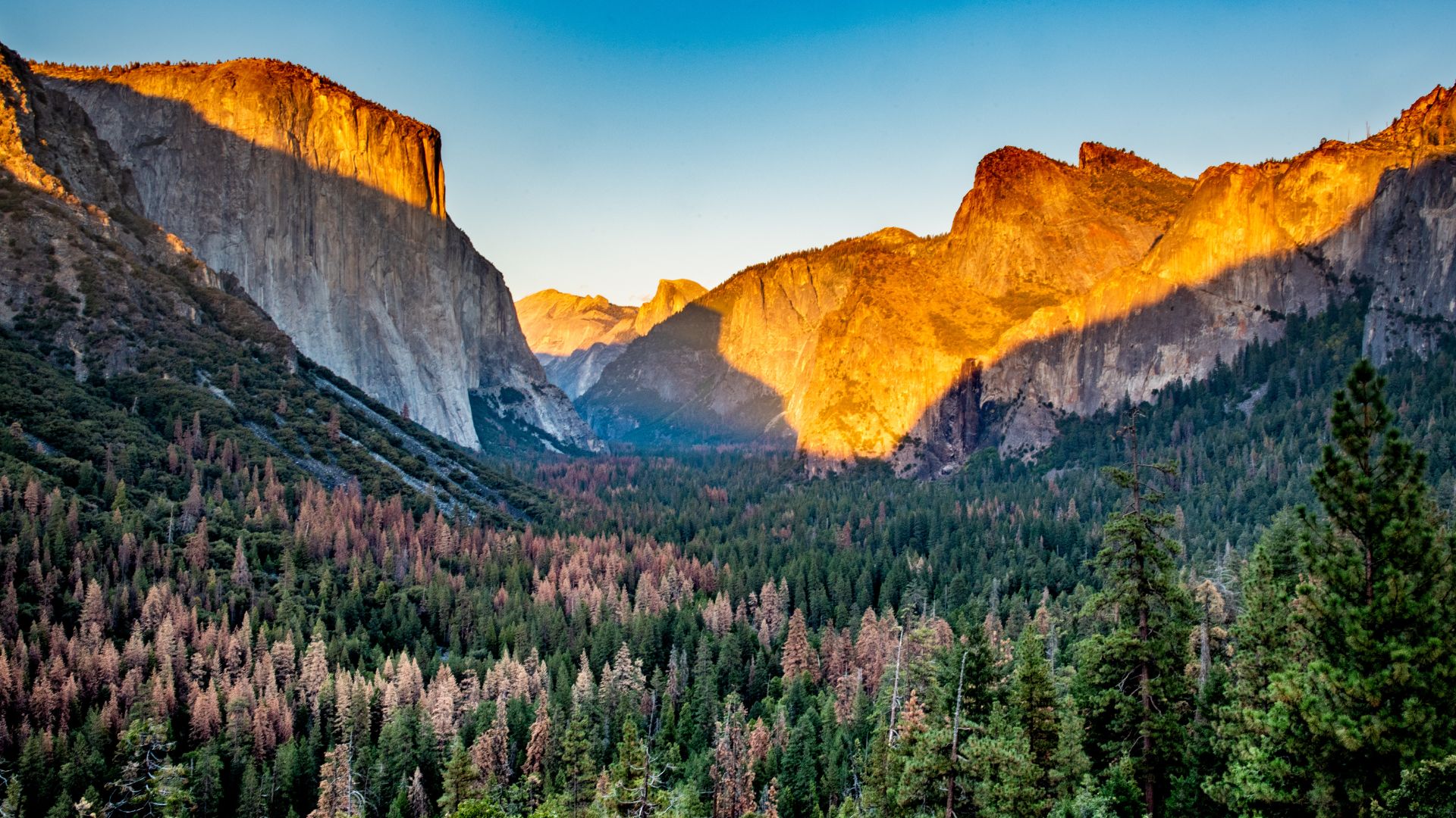
I always kick off Glacier Point Road at Tunnel View, just past the Wawona Tunnel.
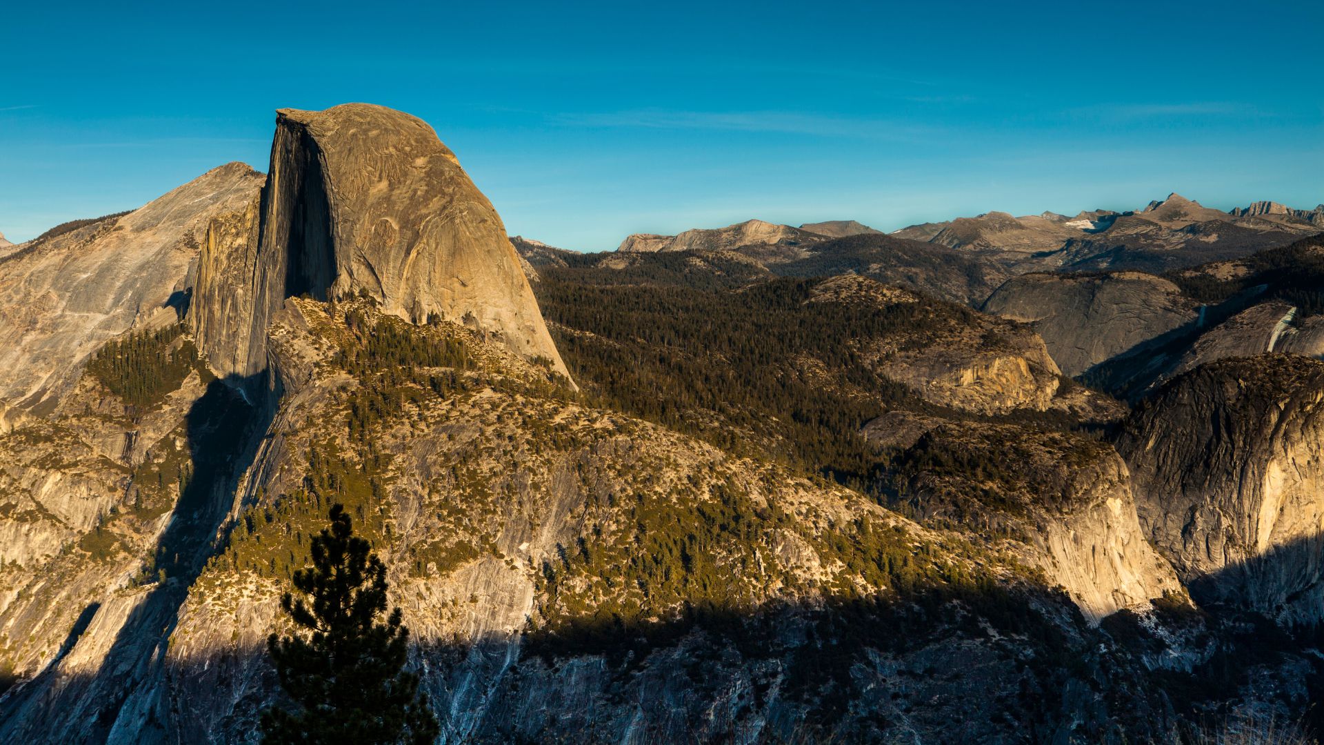
It frames Yosemite Valley perfectly—El Capitan to the left, Bridalveil Fall to the right, and Half Dome looming in the back.
Key Pullouts:
- Tunnel View: The iconic valley shot
- Olmsted Point: Quieter, with a unique angle on Half Dome (quick 0.2-mile walk)
- Washburn Point: Killer views of Vernal and Nevada Falls
- Glacier Point: The big one—panoramic High Sierra vistas
Washburn Point actually gives clearer waterfall views than Glacier Point, so don’t skip it.
You can see both Vernal and Nevada Falls pouring down the cliffs.
Each stop shows a new side of the landscape, and the drive itself is part of the fun as you climb 3,200 feet above the valley.
Exploring Sentinel Dome and Glacier Point
Glacier Point sits 3,214 feet above Curry Village.
The short, paved trail from the parking lot makes it accessible for everyone.
It’s my favorite Yosemite viewpoint—Half Dome dominates the horizon, and Yosemite Falls drops straight down to the north.
From Glacier Point, you’ll spot:
- Half Dome’s sheer face
- Yosemite Falls (tallest in North America)
- High Sierra peaks stretching out forever
- The entire valley floor way below
Sentinel Dome is a quieter alternative.
It’s a 2.2-mile roundtrip hike, mostly flat except for the final scramble up the dome.
Bring water and start early if you can—the sun gets intense.
From up top, you get 360-degree views, including El Capitan and the Mariposa Grove area.
It really puts Yosemite’s scale and geology in perspective.
Glacier Point Road Essentials: Closures and Access
Glacier Point Road usually opens in late May and closes by November, depending on snow.
Access by season:
- Summer (June-October): Drive right up
- Winter (December-March): Only open for cross-country skiing (10.5 miles)
- Spring/Fall: Always check conditions—weather changes fast
I always check the park website before heading out.
The drive from Yosemite Valley takes about an hour, turning onto Glacier Point Road at Chinquapin from Highway 41.
Things to remember:
- No gas stations along this route
- Pack water and snacks
- Parking fills up fast in summer, sometimes by mid-morning
- Tour buses run when the road’s open
Winter trips take planning—cross-country skiers can reach Glacier Point, but it’s a 21-mile round trip from Badger Pass.
The road links up with Wawona to the south, so you can easily combine it with other High Sierra stops.
Hetch Hetchy Road: Untamed Backcountry and Reservoir Scenery
This 16-mile drive winds to Hetch Hetchy Reservoir through quiet country—think towering waterfalls like Wapama Falls and the old O’Shaughnessy Dam.
You’ll pass through pine forests and find trailheads to giant sequoia groves.
Driving to Hetch Hetchy Reservoir: What to Expect
I usually enter via the Big Oak Flat entrance, then turn onto Evergreen Road (about a mile west of the entrance station).
After 7.5 miles, I stay on Hetch Hetchy Road for the last stretch to the reservoir.
The whole trip from Evergreen Road to the water takes about an hour and fifteen minutes from Yosemite Valley.
Most of the year, the road stays open, though snow can close it in winter.
Hours match the entrance station—usually after 8 am.
The views of the reservoir tucked in its glacial valley are stunning.
I always notice how few people are here. It’s a peaceful break from the Valley’s crowds.

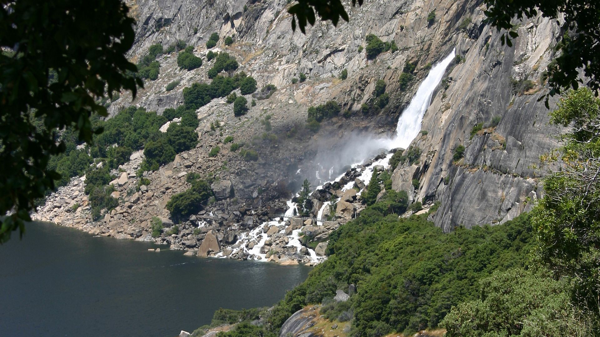
Wapama Falls and O’Shaughnessy Dam
O’Shaughnessy Dam holds back the Tuolumne River, creating the reservoir.
You can walk across the dam and check out interpretive signs that tell the area’s story since 1913.
Wapama Falls drops 1,200 feet right into the reservoir.
The hike out is about four miles roundtrip, and you’ll also see Tueeulala Falls (an 880-foot drop).
If you’re feeling ambitious, the trail keeps going to Rancheria Falls—13 miles roundtrip.
Spring and early summer are the best times, when snowmelt turns the falls into roaring torrents.
Secluded Trails, Pine Forests, and Giant Sequoias
Tall pine forests shade the road, letting sunlight filter through in shifting patterns.
I’ve found a few unmarked pullouts that are perfect for photos or just a quiet moment.
Several trailheads lead to groves of giant sequoias—those ancient trees tower over the pines and really put time in perspective.
If you like fishing, you’ll find brook, rainbow, and brown trout in the reservoir and the upper Tuolumne River.
Most days, I have whole stretches of trail to myself—so different from the busy Yosemite paths.
You can’t help but feel like you’ve discovered a hidden side of the Sierra.
Sierra Vista Scenic Byway: Hidden Gems of Central California’s High Country
This 83-mile loop winds through the Sierra Nevada, revealing massive granite domes, ancient sequoia groves, and pristine mountain lakes. It’s a route that feels a little wild and untouched, especially compared to the busier highways.
Key stops like Nelder Grove and Globe Rock pop up along the way, plus there are camping spots at Mammoth Pool if you want to linger.
Key Stops: Nelder Grove and Globe Rock
When I first wandered into Nelder Grove, I couldn’t believe how quiet it was. Most folks head to Mariposa Grove in Yosemite, but here, you get peaceful trails winding through ancient giants.
More than 100 mature sequoias tower overhead. The Shadow of the Giants Trail—just a 1.1-mile loop—makes it easy to get up close to these incredible trees.
Globe Rock is another stop that really stands out. This huge granite dome just begs you to stop for photos, and honestly, it shows off the Sierra Nevada’s quirky geology.
Best visiting times:
- Early morning for photography
- Late afternoon for softer lighting
- Weekdays if you want some real solitude
Since the grove sits at 5,000 feet, the air feels refreshingly cool, especially in summer.
Mile High Overlook and Mammoth Pool
The Mile High Overlook absolutely lives up to its name. I remember standing there, just staring at endless granite peaks and forested valleys.
From this spot, you can see for miles—deep canyons, rugged ridges, and forests that seem to go on forever. The overlook perches at about 5,280 feet above sea level.
Mammoth Pool is a sprawling reservoir tucked into a dramatic granite canyon carved by the San Joaquin River.
You can fish for trout, launch a boat, swim in designated spots, or just snap photos of those wild granite formations.
Getting to Mammoth Pool means driving winding mountain roads, but there are scenic pullouts everywhere. Each one offers a new angle on the peaks and valleys.
Camping and Outdoor Adventures Along the Byway
Camping along the Sierra Vista Scenic Byway feels like a real escape. Nelder Grove Campground sits right among the giant sequoias and keeps things simple with basic amenities.
There are seven sites, all first-come, first-served. The elevation is 5,300 feet, and you’ll find vault toilets and fire rings—nothing fancy, but that’s part of the charm.
Mammoth Pool Campground sits lakeside with 47 sites and a few more comforts, like potable water and a boat launch.
If you’re after higher elevation and trail access, Clover Meadow Campground is a great launch point for backpacking into the Sierra Nevada backcountry.
Outdoor adventures are everywhere. You can hike up to Fresno Dome, fish in mountain streams, snap wildlife photos, or just lay back and stargaze under that high-altitude sky.
Campgrounds usually open from May to October, though snow sometimes changes the schedule.
Lake Tahoe, Donner Pass & Ebbetts Pass: Northern High Sierra Scenic Routes
The northern High Sierra packs in three very different drives. There’s Lake Tahoe with its impossibly clear water and Emerald Bay, historic mountain towns near Donner Pass, and the wild, winding Ebbetts Pass National Scenic Byway.
Emerald Bay and Lake Tahoe’s Alpine Beauty
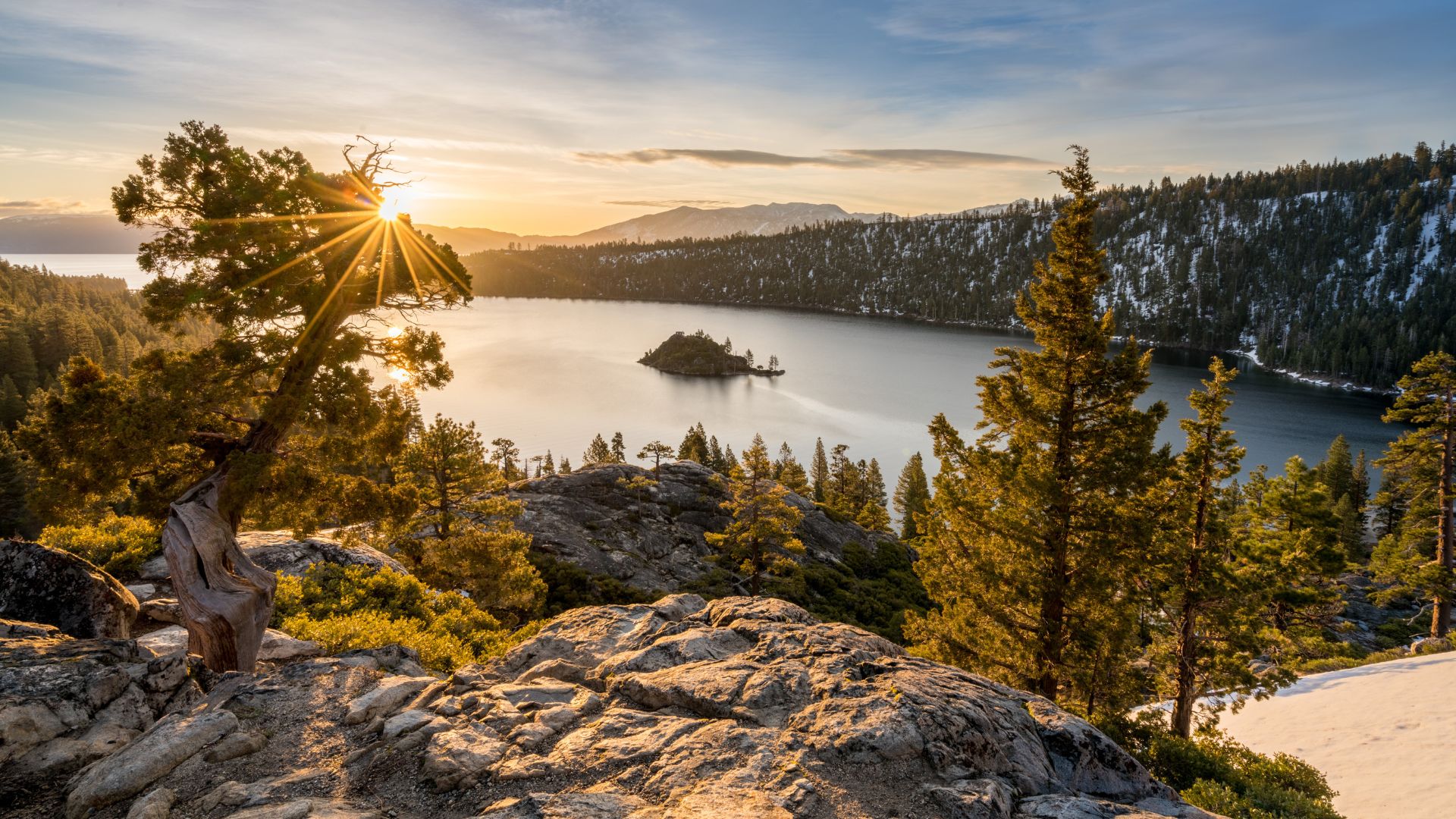
I’ll just say it—Emerald Bay really is Tahoe’s crown jewel. Highway 89 gives you a perfect overlook of that bright blue water, with Fannette Island right in the middle.
Driving the full loop around Lake Tahoe covers 72 miles. I like to start at South Lake Tahoe and head north on Highway 89.
Stops I wouldn’t miss:
- Emerald Bay State Park for those postcard photos
- Eagle Falls trailhead if you want a quick hike
- Sand Harbor Beach over on the Nevada side
The water stays cold—always—but the views never disappoint, no matter the season. Spring brings roaring waterfalls, and in fall, the aspens go gold. It’s gorgeous.
Donner Lake and Historic Mountain Towns
Donner Pass rises to 7,085 feet along Interstate 80. The drive up is surprisingly easy from either direction.
On calm days, Donner Lake mirrors the peaks above. After your drive, the historic town of Truckee is a fun place to grab a bite or browse the shops.
Why I love this route:
- It’s easy to reach from major highways
- There’s real history here, especially about the Donner Party
- You get those classic alpine lake views
- Truckee just feels like a true mountain town
Definitely stop at Donner Memorial State Park. The museum tells the area’s story, and the lake has a small marina for boating if you’re feeling adventurous.
Ebbetts Pass National Scenic Byway
This 61-mile stretch along Highways 4 and 89 links Arnold to Markleeville. Honestly, I found it way more remote and untamed than the other Sierra passes—almost like you’ve stumbled onto a secret.
Pacific Creek near Hermit Valley totally blew me away. The water just crashes through these wild granite canyons, especially when the snow starts melting in spring.
They close the pass for winter, and it doesn’t usually open up again until May. Lake Alpine sits right at the top, and sometimes, even in summer, you’ll see chunks of ice floating around.
Here are a few highlights I stumbled across:
- Mosquito Lakes—perfect if you want to cast a line and just chill
- Cape Horn Vista, which serves up some killer mountain views
- Silver Creek, winding right alongside the road
- A handful of old cabins and mining sites that hint at the area’s rough past
The road really tightens up near the summit and gets pretty twisty. I’d say slow down and pull over whenever you can—those photo ops are worth it.