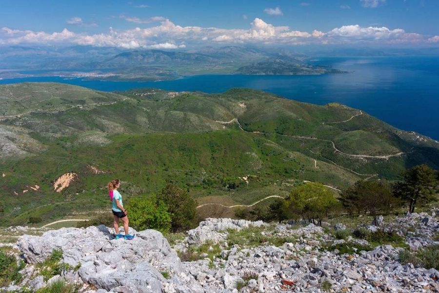
I’ll never forget the moment I reached the summit of Mount Pantokrator. The whole island of Corfu just sprawled out beneath me, almost like someone had unrolled a living map at my feet.
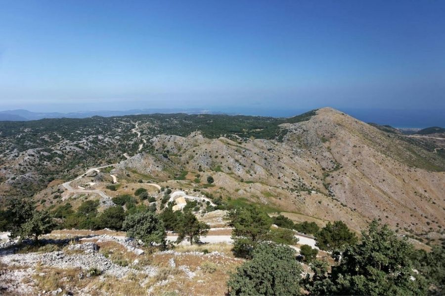
Getting there wasn’t just about the destination. The drive itself winds up through tiny villages and along mountain roads that seem to climb forever, twisting higher and higher until you wonder if the car will just sprout wings.
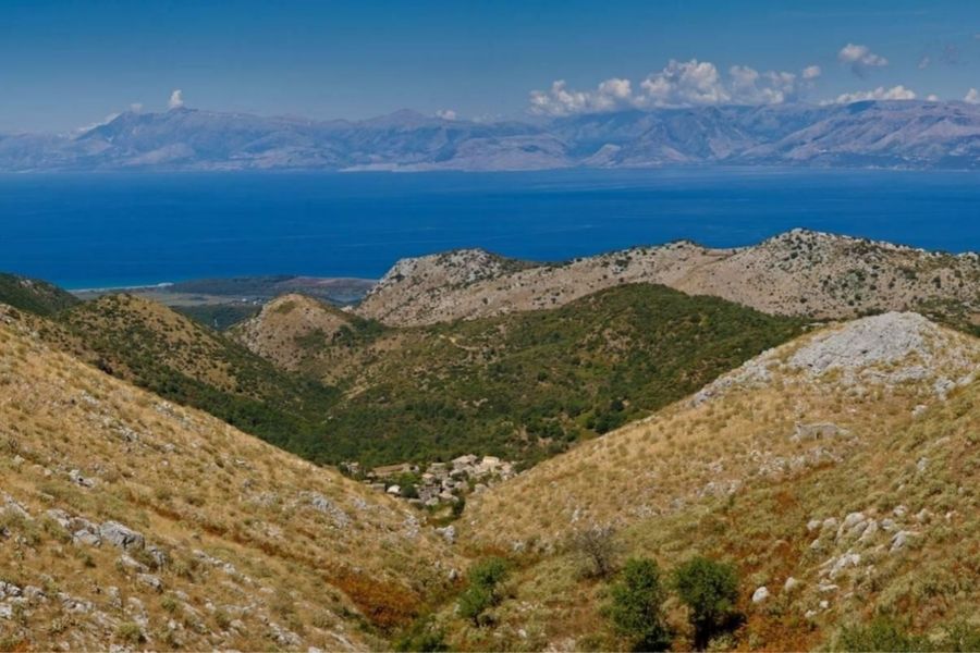
Mount Pantokrator rises 906 meters above sea level and, honestly, the views from up there are absolutely wild. On a clear day, you can spot Albania, Italy, and pretty much every inch of Corfu. What started as a low-key day trip somehow turned into one of my top memories on the island—complete with that weird ear-popping sensation that comes from real elevation.
I learned pretty quickly that the best adventures often happen when you just go for it and take the scenic route. I picked up some useful driving tips, stumbled across hidden gems, and realized why this drive really should be on every Corfu itinerary.
Essential Facts About Mount Pantokrator
Mount Pantokrator towers over Corfu at 906 meters, making it the highest peak in the Ionian Islands. There’s a ton of history up here, with a centuries-old monastery, sweeping views, and a sense of cultural importance that you can actually feel.
Mount Pantokrator’s Location and Elevation
You’ll find Mount Pantokrator in the island’s northeast corner. It really stands out—no matter where you are on Corfu, you can spot its silhouette dominating the skyline.
The mountain tops out at 906 meters (2,972 feet), which is plenty high for those jaw-dropping vistas.
Because of its position, you get these incredible sightlines. On a clear day, I could see the coast of Albania, tiny islands like Othoni, Erikoussa, and Mathraki, and—if you squint—Italy about 130 kilometers away.
Names and Historical Background
Locals call it a few different things: Mount Pantokrator, Pantocrator, or Mount Pantokratoras.
The name means “ruler of all” in Greek, which fits considering the monastery that sits right at the summit.
The current monastery stands where an older Angevin monastery was built back in 1347. That first building didn’t make it past the early 1500s, but the local villages pitched in to rebuild starting in 1689. The church facade was added in the 19th century.
Why Mount Pantokrator Is Famous
People come up here for three main reasons. First, there’s the Monastery of Pantokrator at the peak—a real working religious site, not just a relic.
There’s also a big telecommunications station, which, while not exactly picturesque, does its job for the island.
And then there’s the annual Pantokrator Festival. Locals and visitors gather for traditional music, dancing, and food—if you time it right, you’ll get a real taste of Greek culture.
But honestly, the biggest draw is the view. I stood there and saw the whole island, the Albanian mountains, and even a hint of Italy when the weather played nice.

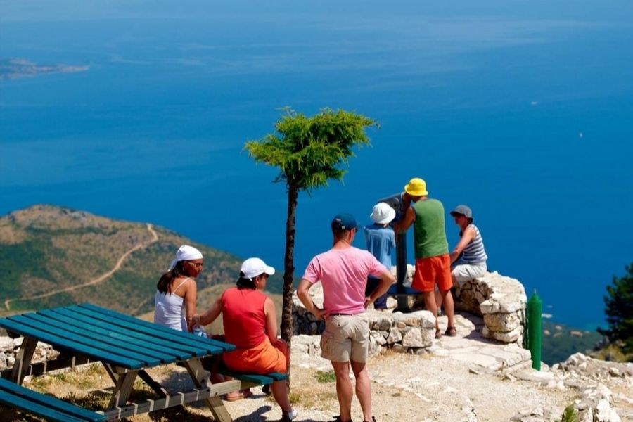
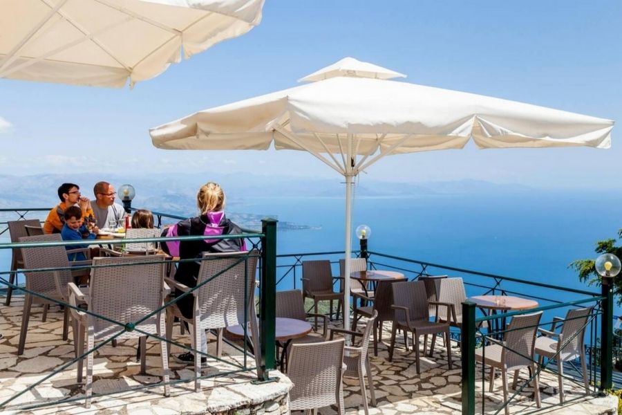
There’s a small café at the summit, but parking is a bit of a scramble, especially in peak season.
Preparing for the Drive to the Summit
Driving up to Pantokrator’s 906-meter peak takes some planning if you want to enjoy it instead of stressing out. The trip from Corfu town clocks in at about 40 minutes, but timing and road conditions can make a big difference.
Best Routes and Road Conditions
For me, the most straightforward route started in Corfu town and headed north through Dassia. It takes about 40 minutes and the coastal views along the way are just—wow.
As you get closer to the summit, the roads narrow and twist. The last bit is especially tight and can be a challenge if you’re in anything bigger than a compact car.
Road Surface Types:
- Lower sections: Smooth, paved roads.
- Mid-elevation: Narrower, still paved, but those turns get sharper.
- Final approach: Some dirt patches near the monastery.
I always check road conditions before heading out, especially if it’s rained recently. Wet mountain roads in Greece can get slick fast.
When to Visit for Panoramic Views
If you want those crisp, clear views, go early. I’ve found that between 8 and 10 AM is prime time—after that, haze starts creeping in.
Seasonal Tips:
- Spring/Fall: Cooler, with great visibility.
- Summer: Hazy, but you get longer days.
- Winter: Air is clearest, but sometimes roads close.
I always peek at the weather forecast before setting out. There’s nothing worse than driving all that way and finding the summit socked in with clouds.
Driving Tips and Safety Considerations
Those narrow mountain roads demand your full attention. I keep my speed low, especially on the hairpin bends, and pull over to let locals zip by.
Some practical safety tips:
- Top off your gas tank before you start climbing.
- Bring water and some snacks—trust me, you’ll want them.
- Double-check your brakes before heading back down.
- Use low gears on steep descents.
Cell coverage gets spotty up high, so I always let someone know my route and when I plan to be back.
There aren’t many guardrails in places. I focus on the road and save the sightseeing for when I’m safely parked.
Time Required and Parking Options
Set aside 3-4 hours for the whole thing—drive up, explore, and head back down.
Rough breakdown:
- Up to the summit: 40 minutes
- Wandering the summit: 60-90 minutes
- Drive back: 35 minutes
Parking at the monastery is tight—maybe 20 spots if you’re lucky. I try to arrive early during busy times.
If the lot’s full, you can park in Strinilas village, the highest settlement on Corfu. From there, it’s about a 90-minute hike to the top. Not a bad Plan B if you’re feeling energetic.
Experiencing the Panoramic Views
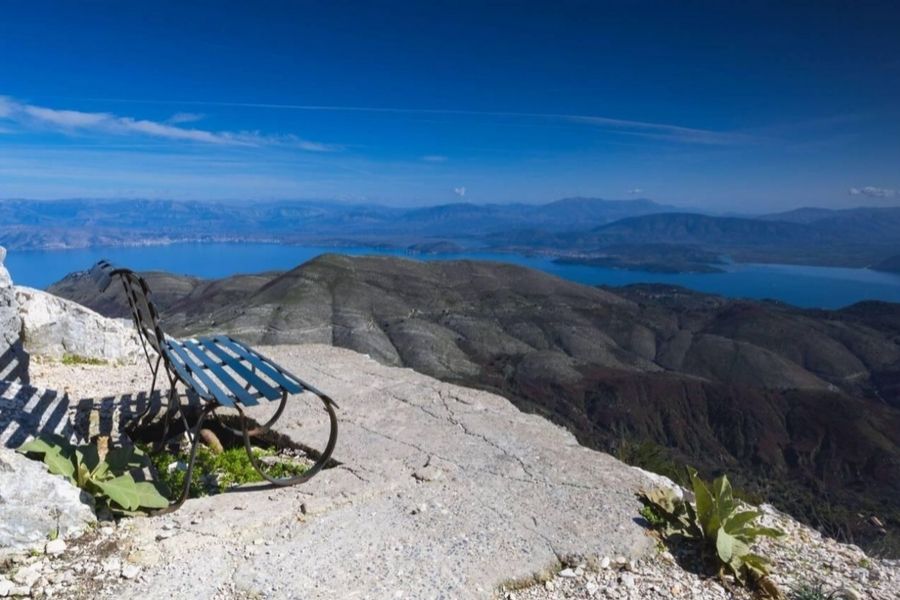
Standing at the 906-meter summit, I felt like I could see half the world. The Ionian Sea stretches forever, and on a good day, you’ll spot coastlines and islands way beyond Corfu.
Summit Vistas: What Can You See?
From the peak, Corfu’s shape suddenly makes sense. The whole island unfurls below you, every beach and bay in plain view.
Here’s what caught my eye:
- All of Corfu’s coastline and those famous beaches.
- The Old Town of Corfu—tiny from up here.
- Neighboring Ionian islands.
- The mountain ridges of Albania to the east.
- Italy’s outline, if the air is crystal clear.
The 14th-century Pantokrator Monastery anchors the summit, adding this quiet sense of history to the wild scenery.
Morning is best for visibility. Once the haze rolls in, the views get a bit muted.
Highlights of the Ionian Sea and Corfu Island
To the west, the Ionian Sea looks endless. The deep blue water pops against Corfu’s green hills.
Some standout features:
- Both eastern and western coasts of Corfu at once.
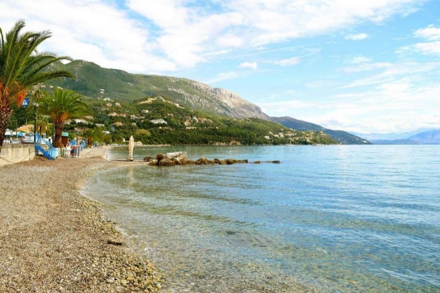
- Popular beaches like Paleokastritsa and Sidari.
- The narrow channel separating Corfu from mainland Greece.
- Fishing villages scattered along the shore.
- Terraced hillsides dotted with olive trees.
From up here, you really see how diverse Corfu’s landscape is. Olive groves blanket the interior, while sandy beaches and coves ring the island.
I could pick out the bigger towns easily. The contrast between busy resorts and untouched countryside was pretty striking.
Observing Albania, Lake Butrinto, and Beyond
Looking northeast, Albania feels incredibly close—just a couple kilometers across the water at the narrowest point.
What’s visible over there:
- The city of Saranda.
- Lake Butrinto, with its wetlands.
- Mountain ranges stretching inland.
- Traditional Albanian villages hugging the coast.
The Albanian mountains rise up dramatically, a sharp contrast to Corfu’s rolling hills.
On especially clear days, I could spot boats moving between the two countries and even see buildings along the shore.
It’s wild how close Greece and Albania are here. From this height, you really sense the connection between the two.
Points of Interest at the Summit
The top of Mount Pantokrator isn’t just about the view. You’ll find a historic monastery, a small café, and—whether you like it or not—a big telecommunications tower that’s hard to miss.
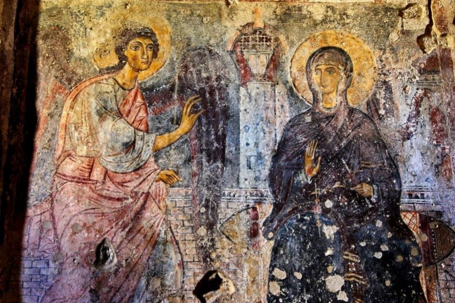
Pantokrator Monastery History and Architecture
The Monastery of the Ipsilos Pantokrator is the heart of the summit. It’s small, built in classic Greek Orthodox style with sturdy stone walls and a red tile roof.
This place has stood for centuries and still welcomes worshippers. Locals come up for ceremonies and festivals.
The architecture is simple and solid—Byzantine lines, built to handle mountain weather.
Inside, I found religious icons and traditional artwork. It’s humble, more focused on spirituality than showiness.
Stone paths wind around the grounds, leading to quiet corners and viewpoints.
Key features:
- Stone construction
- Red clay roof tiles
- A small, icon-filled chapel
- Courtyards for reflection
- Materials suited to mountain life
The Summit Café and Facilities
There’s a tiny café near the monastery, usually open in peak season. After the drive, I was grateful for a hot coffee and a snack.
They serve Greek coffee, soft drinks, and some pastries—nothing fancy, but it hits the spot.
Amenities you’ll find:
- Hot and cold drinks
- Greek pastries
- Restrooms
- Shaded seating
- A few souvenirs
Parking handles cars and small tour buses, though it fills up quickly. The paved area keeps your car safe while you wander.
Opening hours change with the seasons, but summer is your best bet for full service.
Telecommunications Station and Local Features
You can’t miss the big telecommunications tower at the summit. It’s not exactly pretty, but it’s vital for the island’s communications.
That metal giant handles cell and radio signals for all of Corfu. Multiple antennas crowd the tower.
Other summit sights:
- Stone markers showing the elevation
- Weather gear
- Viewing platforms
- Info boards about Pantokrator
- Trail markers for hikes
The mix of old monastery and modern tech is a bit odd, but both matter to the locals in their own way.
Exploring Mount Pantokrator’s Surroundings
The summit is just the start. Around Mount Pantokrator, you’ll find ancient villages and hiking trails that reveal a whole different side of Corfu. This corner of the Ionian Islands is packed with authentic Greek culture and outdoor adventures.
Traditional Villages: Palia Perithia and Spartilas
Palia Perithia claims the title of Corfu’s oldest inhabited village, dating back to the 14th century. Wandering its stone lanes, I felt like I’d stepped into another era.
Perched high on the mountain, the village was once a safe haven from coastal raiders. Its narrow streets and stone houses have hardly changed.
Several tavernas serve up hearty local dishes. If you want a real taste of mountain life, this is the place.
Spartilas is known as the “Window on Corfu,” and it lives up to the name. The views stretch across the island’s northern coast—absolutely stunning.
It’s a bit more accessible than Palia Perithia but still keeps its traditional charm.
Local shops here sell handmade crafts and regional goodies. The village square is a great spot to catch your breath and soak up the mountain air.
Hiking and Outdoor Adventure Opportunities
The Mount Pantokrator Loop kicks off from Strinilas village, winding its way up to the summit. This circular trail weaves through forests and rocky stretches, so you’re in for a bit of everything.
I found the path pretty well-marked, though a few sections definitely tested my legs. Depending on how many stops you make (and how many photos you can’t resist taking), you’ll probably need 3 to 4 hours to complete it.
You’ll notice alternative hiking paths branching off from the main loop. These side trails lead to unexpected viewpoints and some hidden corners around the mountain—if you’re feeling adventurous, it’s worth a detour.
The whole area feels like a playground for nature photography. I spotted several bird species and quite a few native plants that you won’t find anywhere else but the Ionian Islands.
Trail Difficulty Levels:
- Easy: Strolls through villages or short nature paths
- Moderate: The Pantokrator Loop trail
- Challenging: Off-trail exploring and those steep, heart-pounding ascents
Cultural Events and Local Festivals
The mountain villages scattered around Pantokrator throw some pretty lively festivals all year long. Most of these celebrations tie into Greek Orthodox holidays or cherished local traditions.
During the summer, you’ll find villages like Spartilas and Strinilas buzzing with live music, traditional dancing, and tables groaning under the weight of local food. There’s a real sense of community at these gatherings.
At the very top, the Monastery of Pantokrator holds special religious ceremonies on certain dates. Locals and travelers alike make the climb for these events.
Villages mark their own feast days with processions and big communal meals. I’ve felt the warmth of Greek hospitality most during these moments—there’s nothing quite like it.
Don’t miss the wine festivals if you’re around in the right season. The mountain slopes are dotted with vineyards, and these events really highlight the area’s agricultural roots.
How to Reach Mount Pantokrator from Corfu Town
Reaching Mount Pantokrator from Corfu Town takes about 40 minutes by car. The drive itself is half the fun, with sweeping coastal views that make it hard not to pull over for photos. If you don’t have a car, public buses and a short taxi ride will get you there too.
By Car: Rental Tips and Directions
Honestly, renting a car felt like the easiest way to get to Mount Pantokrator. The 40-minute drive from Corfu Town is packed with jaw-dropping views of the coastline.
Car Rental Tips:
- Any standard car handles the drive—no need for a 4×4 unless you just want one
- Book ahead if you’re visiting during peak season
- Double-check your insurance covers mountain roads
You’ll head northeast from Corfu Town, passing through Ipsos village. After that, just follow the signs pointing toward Spartilas and Strinilas.
The last stretch turns into a dirt road. It’s in good shape but gets narrow, so drive slow and let others pass when you need to.
Key stops along the way:
- Dassia – for those classic coastal views
- Ipsos – your last big village before heading up
- Spartilas – a mountain village with a panorama you won’t forget
I like to set out early in the morning. The lighting’s perfect for photos, and you’ll dodge most of the crowds at the summit.
Public Transportation and Alternative Routes
Buses run from Corfu Town to Ipsos village. From there, you’ll need to hop in a taxi or, if you’re up for it, hike up the steep road to the mountain’s base.
Bus Route:
- Catch the blue bus from Corfu Town to Ipsos
- The ride takes about 20-30 minutes
- Bus times change with the seasons, so check ahead
Taxis from Ipsos can cost a bit, especially for the uphill ride. Some travelers team up with others to split the fare.
If you prefer something organized, you can join a tour from Corfu Town. These usually include transport and stops at picturesque villages like Old Perithia.
The hiking route from Strinilas village is another solid option. This circular trail takes you right to the monastery at the top and usually takes 3-4 hours at a moderate pace.
On a budget? You can combine the bus to Ipsos with a bit of hitchhiking. Locals are often friendly and happy to give you a lift if they’re heading your way.
Frequently Asked Questions
People ask me about Mount Pantokrator all the time. Most want to know how to drive there and what to expect on the way up to that 906-meter summit.
What are the driving directions to reach Mount Pantokrator’s summit?
From Corfu Town, I usually drive north for about 40 minutes. The route first takes me through Ipsos village.
After that, I follow the coast road north, then turn inland toward Barbati or Nissaki.
The road climbs through mountain villages like Strinilas. Signs along the way make it easy to stay on track.
The final section is a dirt road that leads straight to the summit. I just keep it slow and steady until I reach the monastery at the top.
Can you hike to the top of Mount Pantokrator, and if so, what is the difficulty level?
You can absolutely hike to the summit. Several trails start from different villages.
The most popular path begins in Strinilas and stretches about 3 kilometers. For me, it usually takes 1-2 hours, depending on how many photo stops I make.
I’d call the difficulty moderate. There are some steep bits and rocky patches, but nothing too wild.
The Pantokrator Loop trail offers a longer, circular hike that brings you right back to where you started.
If you’re feeling ambitious, the Corfu Trail also passes through Mount Pantokrator. That one’s a much bigger commitment, though.
Are there specific visiting hours for driving up to Mount Pantokrator?
There aren’t any official hours for driving up. I can go up the mountain whenever I want.
The monastery at the summit sometimes keeps limited hours. I usually stick to daylight visits—it’s safer and the views are unbeatable.
Early mornings and late afternoons give you the best visibility. Plus, it’s much cooler during the summer.
I avoid heading up if the weather’s bad. The dirt roads can get slick and risky during heavy rain.
What kind of vehicle is recommended for the drive to Mount Pantokrator’s summit?
I’d suggest a car with decent ground clearance for that last dirt stretch. Most of the way, any regular car does fine.
The paved roads to the villages are easy for all vehicles. Just slow down and watch for potholes on the dirt part near the top.
If you have an SUV or 4WD, the final part feels a bit easier, but honestly, I’ve seen plenty of compact cars make it up.
No matter what you drive, take it easy on the dirt road. There’s loose gravel and a few rough patches.
Is there an entrance fee or parking charge at Mount Pantokrator?
No entrance fee here! Visiting the summit is completely free.
Parking at the top doesn’t cost a thing either. There’s a small lot next to the monastery where you can leave your car.
The monastery itself doesn’t charge admission. You’re free to wander the grounds and soak in the views.
If you join a guided tour, you’ll pay for the service, but if you go on your own, your only real expense is fuel.
What should I bring with me for a trip to Mount Pantokrator’s summit?
Whenever I head up to Mount Pantokrator, I toss a bottle of water and a few snacks in my bag. Trust me, you won’t find many places to grab a bite at the summit, so it’s better to come prepared.
I never leave my camera behind. The views from the top are unreal—on a clear day, it almost feels like you could reach out and touch Albania or maybe even spot Italy in the distance.
Footwear matters more than you’d think. I always go for comfy shoes with decent grip since the monastery grounds and the lookout spots can get pretty uneven.
Even when the sun’s blazing in summer, I bring a light jacket. It can get surprisingly chilly up there at 906 meters, especially if the wind picks up.
Don’t forget sunscreen and a hat. The sun can be relentless, and there’s barely any shade around midday. You’ll thank yourself later!