California’s Lost Coast Trail is honestly one of the wildest, most remote backpacking trips you can take in the lower 48. You get 25 miles of rugged coastline up in Northern California, untouched enough that Highway 1 just gave up and veered inland. The result? An untamed stretch where black sand beaches crash into cliffs and the ocean almost feels like it might swallow you whole.
You need a permit, solid tide planning, and must pack a bear canister—no exceptions. But if you come prepared, the Lost Coast rewards you with a wilderness experience that’s second to none on America’s longest undeveloped shoreline.
I spent three days backpacking the King Range National Conservation Area, and wow, it taught me a lot. Prepping right, timing those tides, and respecting the wild made all the difference. I’ll walk you through what worked (and what didn’t), from snagging permits to dodging bears and finding water.
Trail Overview & Uniqueness
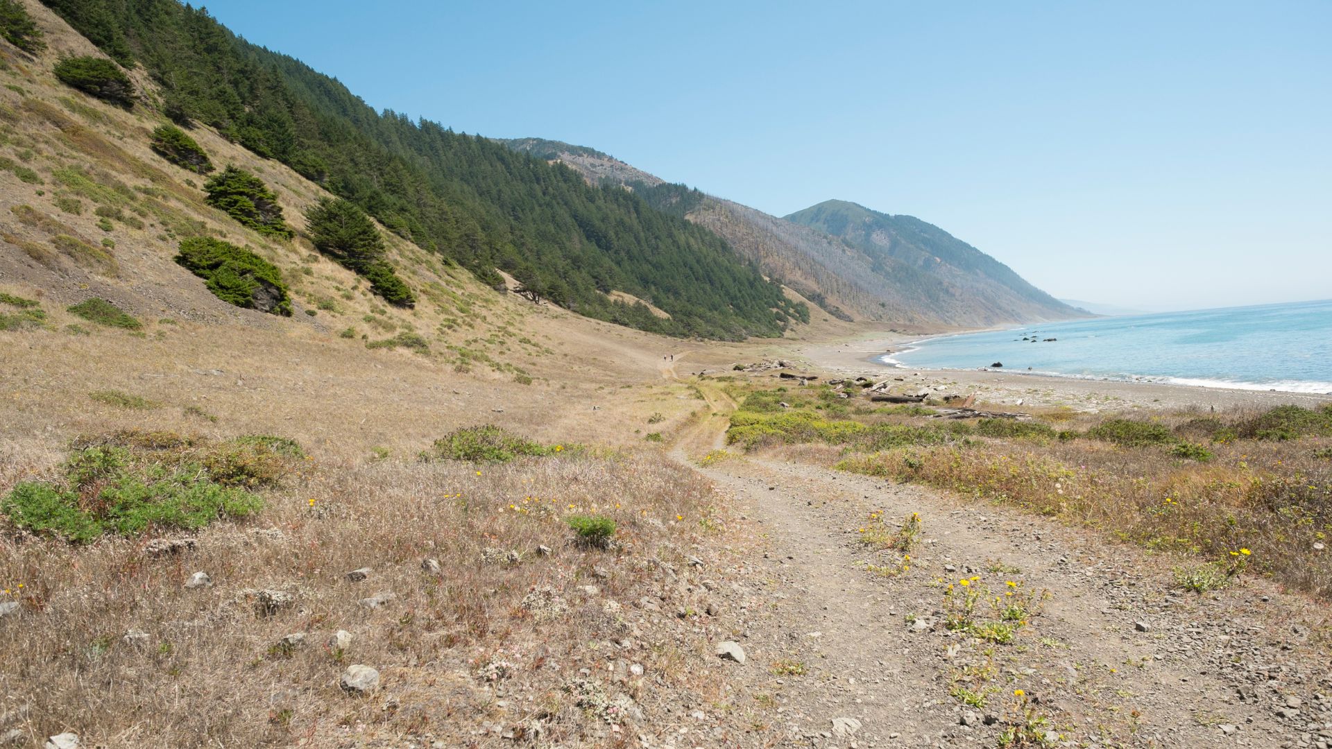
The Lost Coast Trail runs for 25 miles through the King Range National Conservation Area. It’s California’s longest stretch of wild coastline, and you feel it with every step.
This route links up iconic black sand beaches with epic cliffs and old-growth forests. You’ll spend most of your time right along the ocean, sometimes just feet from the waves.
What Makes the Lost Coast Special
The Lost Coast stands apart as California’s most remote coastal wilderness. I’m not exaggerating—Highway 1 literally couldn’t handle the terrain.
No roads slice through here. The King Range National Conservation Area keeps this place wild, and for long stretches, I saw nothing but nature.
Wildlife is everywhere. I caught glimpses of Roosevelt elk, black bears, and plenty of seals lounging on the rocks. The trail weaves through everything from scrubby bluffs to ancient forests.
Where the mountains slam into the Pacific, you get these jaw-dropping views. Cliffs drop straight into the water. Honestly, some of the most dramatic coastline I’ve ever seen.

Classic Route: Mattole Beach to Shelter Cove
Most folks hike from Mattole Beach in the north to Black Sands Beach by Shelter Cove in the south. The 25 miles usually take two or three days.
Starting at Mattole just feels right—the terrain flows better, and you’re less likely to get battered by headwinds. You’ll hug the coastline, so you have to keep an eye on the tides.
Key spots along the way:
- Mattole Beach (northern trailhead)
- Punta Gorda Lighthouse
- Cooski Creek
- Buck Creek
- Black Sands Beach (southern endpoint)
I’d suggest giving yourself three days if you can. That way, you get to soak in the scenery instead of just grinding out miles.

Black Sand Beaches and Rugged Terrain
Those black sand beaches? They’re unreal. Volcanic rock and river sediment create a landscape that feels almost otherworldly.
Walking on black sand isn’t easy. The ground shifts and pulls at your feet, so every mile feels longer. Trekking poles saved my knees and kept me upright.
The trail throws a bit of everything at you—boulder fields, creek crossings, steep climbs, and even some scrambling if you hit the tides wrong. Weather can turn on a dime.
You’ll face:
- Soft, shifting black sand
- Rocky tide pools
- Unbridged creek crossings
- Steep cliffside paths
It’s tough, but that’s what makes it stick in your memory. Every mile brings something new.

Permits, Regulations & Planning Essentials
You need a permit for any overnight trip here, and the Bureau of Land Management doesn’t mess around. Plan ahead—permits sell out, especially during the busy season.
How to Secure a Permit
I always book through Recreation.gov. You’ll need a backcountry permit for any overnight stay.
Permits drop online, and they go fast. Check the King Range Wilderness Permits page on Recreation.gov and be ready when your dates open.
Types of permits:
- Backcountry Permit: Overnight trips only
- Day Use Permit: For day hikes
If you’re feeling lucky, the King Range Visitor Center hands out three walk-up permits daily via a lottery at 8am. On weekends, Friday’s lottery covers the whole weekend.
Spring and summer weekends fill up in a blink. I always keep a few backup dates in mind.
Bureau of Land Management Rules
The BLM has some pretty strict rules for the King Range Wilderness. I always check tide charts before booking since some trail sections disappear at high tide.
Some key rules:
- No camping at Black Sands Beach Trailhead
- Camp only north of Telegraph Creek
- Wear sturdy hiking boots
- Check the marine forecast before heading out
The northern route runs 24.6 miles from Mattole to Black Sands Beach. The southern bit covers 9 miles from Hidden Valley to Needle Rock.
I always check the King Range website for current conditions. The roads in are narrow and winding, so budget extra time.

Leave No Trace Requirements
Leave No Trace isn’t just a suggestion here—it’s required. I pack out all my trash and waste. This place is fragile, and it needs all the help it can get.
What I do:
- Pack out everything, even toilet paper
- Use established campsites if possible
- Keep fires below the high tide line
- Don’t mess with wildlife or plants
There’s water along the beach, but I always treat it. I avoid camping in dunes and stick to spots that are already impacted.
Rangers do check. I’ve seen them out there, making sure folks follow the rules and teaching about waste disposal.
Route Logistics & Timing Your Trek
This trail takes some real planning—tides, shuttles, even the season matter. Most people hike the 25-mile route from Mattole Beach to Black Sands Beach in three or four days, but you have to time those tidal crossings right or risk getting stranded.
Trail Access and Shuttle Options
You’re dealing with two trailheads, two hours apart on winding roads. I always hike southbound (SOBO) from Mattole to Black Sands Beach. It just makes everything easier.
Why southbound?
- The wind pushes you along
- Shuttle logistics are simpler
- It’s a quicker drive from the Bay Area
Getting there:
Lost Coast Adventure Tours runs two shuttles daily—7 AM and 12:30 PM. It’s about a two-hour ride and costs $95 per person.
The road is no joke—rough, twisty, and slow. I get carsick, so I always grab the front seat and pop some Dramamine.
There’s also the key swap method. Meet another hiker going the other way, swap car keys in Garberville, and trade back on the trail. The Lost Coast Trail Facebook group is the best place to set that up.
Navigating Tides and Tidal Charts
You can’t ignore the tides here. Three sections become impassable at high tide, and you really don’t want to get caught.
The tricky spots:
- Punta Gorda Lighthouse: Cross only below 5 feet
- Sea Lion Gulch to Randall Creek: Below 2.5 feet
- Big Flat to Gitchell Creek: Below 3 feet
NOAA’s tide chart for Shelter Cove is my go-to. Set the interval to one minute and plug in your threshold. Look for green bars—those are your safe windows.
My advice:
- Make sure low tide lines up with daylight
- Plan for a slow pace (1 mph) in tidal zones
- Start crossings as the tide is dropping
- Some days just don’t work—be flexible

Best Seasons to Backpack
I like hiking here between May and October. Summer just gives you the best shot at good weather, long days, and calm surf.
Why summer rocks:
- Less rain and storms
- More daylight for tricky crossings
- Smaller surf
- 60-person daily permit quota
Winter’s a different beast:
- More rain and big surf
- Shorter days make planning tough
- Some streams get too dangerous to cross
- Only 30 permits per day
The King Range doesn’t get snow, so winter hiking is possible. Just be ready to change plans if things get sketchy.
June through September has always been the sweet spot for me, especially if you’re new to the Lost Coast.
Backpacking Preparation & Gear
The Lost Coast is no place to wing it. The weather’s unpredictable and you’re far from help, so your gear really matters.
Essential Packing List
Clothing and Layers
I brought two moisture-wicking shirts, one insulated jacket, and a shell. The weather flips fast, so I kept both light and warm layers handy.
I wore long pants every day—shorts just aren’t worth the risk with all the poison oak and ticks. I treated everything with Permethrin before the trip.
Footwear Strategy
Broken-in hiking boots are a must. I also used lightweight ankle gaiters to keep sand out. After a long day, camp shoes felt like heaven.
Sleep System
A 30-degree sleeping bag worked for me on chilly nights. My sleeping pad had an R-rating of 3—just enough insulation from the cold ground.
Water and Hydration
I carried a 3-liter water bladder. It was enough to get me between water sources without feeling like a pack mule.
| Essential Items | Weight Priority |
|---|---|
| Sleeping bag (30°F) | High |
| Water bladder (3L) | High |
| Hiking boots | High |
| Ankle gaiters | Medium |
| Camp shoes | Low |

Rain Gear and Weather Prep
Waterproof Layers
A breathable, waterproof jacket with a hood saved me from the wind and rain. It fit over all my layers.
Rain pants went over my hiking pants. I picked lightweight ones that packed down small but still kept me dry.
Staying Dry
I lined my pack with a heavy trash bag and used dry bags for my electronics, sleeping bag, and spare clothes.
Even on dry days, the coastal fog soaks everything. Quick-dry fabrics are the way to go—leave the cotton at home.
Bear Canisters and Wildlife Safety
Bear Canister Requirements
I rented a bear canister from the ranger station. It fit three days of food for me when I packed smart.
I stashed all my food, trash, and toiletries in the canister and kept it at least 100 feet from my tent. Don’t put it near a cliff unless you want to watch it roll into the ocean.
Wildlife Precautions
I always keep a tidy camp—no food left out, ever. Black bears roam this area, and sloppy food storage just causes problems for everyone.
I use unscented toiletries and toss them in the canister, too. Even toothpaste and deodorant can attract critters.
Navigation Tools and Trekking Poles
Trekking Poles
Trekking poles saved my knees and kept me steady on loose rocks and creek crossings. I brought collapsible poles that I could adjust for any terrain.
The sand is deep and uneven, so poles really help keep you upright.
Navigation Equipment
I carried a topo map in a waterproof case and a compass, just in case my GPS died. The fog can roll in fast and make everything look the same.
My phone’s GPS worked most of the time, but I downloaded offline maps before I left. I brought a battery charger to keep things running.
Tide charts are a must. I studied them before the trip and kept a waterproof copy on me.
Trail Highlights & Wildlife Encounters
The Lost Coast Trail is a wildlife lover’s dream. Marine mammals show up everywhere—I spotted seals, sea lions, and tons of seabirds. Tide pools teemed with colorful marine life, and every turn brought something new to discover.
Marine Life: Seals, Sea Lions, and Sea Otters
I kept spotting harbor seals sprawled out on rocky ledges as I wandered along the trail. They really come alive during low tide, hauling themselves up to soak in the sun and just lounge around.
Sea lions kept popping up in the surf. I watched them body-surfing the waves, diving after fish right by the shore. Their barking carried down the beach—especially if you’re up early, you can’t miss it.
Catching a glimpse of sea otters felt like a treat. I saw a couple floating on their backs in the kelp, using rocks to smash open sea urchins and shellfish. They hung out about 50 yards offshore, close to Big Flat Creek.
Low tide and those quiet early hours gave me the best chances to see all this marine action. I always stayed at least 150 feet away from the animals—no exceptions, since that’s the law.

Tide Pools and Coastal Scenery
The tide pools along the Lost Coast totally blew me away with their variety. I found purple sea urchins, neon-orange sea stars, and green anemones clinging to the rocks like little jewels.
Mussels blanketed most of the rocks in thick, blue-black clusters. When I got close, tiny hermit crabs darted between the pools. I even stumbled across some bright sea lettuce and other quirky marine algae.
Between Big Flat and Gitchell Creek, the scenery just went wild. Giant sea stacks shot up from the surf, and waves thundered against the black sand—honestly, it’s a little surreal.
Timing matters here. I planned my tide pool adventures for the lowest tides, which opened up parts of the coast that disappear under water when the tide rolls in.
Wildlife Safety and Observation
I always kept a good distance from wildlife during my hike. Federal law says you need to stay at least 150 feet away from marine mammals.
Don’t even think about walking right up to seals or sea lions. They’re surprisingly fast on land, and if they feel threatened, they might bite. I brought along my binoculars—honestly, it’s the best way to get a close look without causing any trouble.
Tide pool ethics really matter out here. I made sure to look, not touch. Walking only on bare rock helped me avoid harming the delicate creatures living in those pools.
Even though black bears don’t show up often, I still stashed all my food in bear canisters. Roosevelt elk roam these parts too, and I spotted their tracks near some freshwater streams.