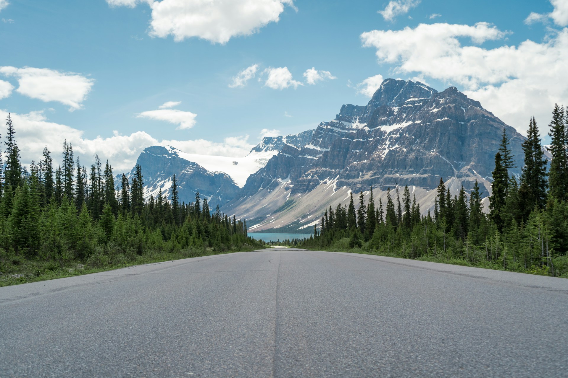
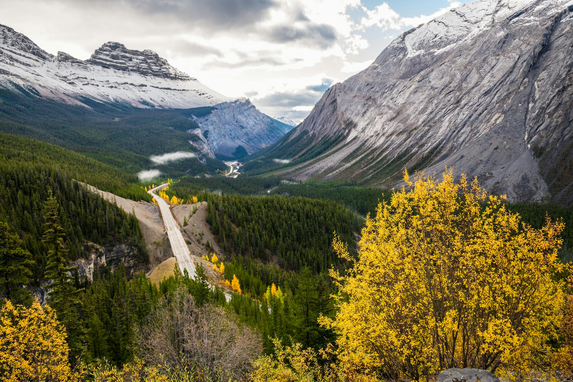
Driving through the Canadian Rockies on Alberta’s Highway 93, I finally understood why travel experts rave about this route. The Icefields Parkway runs 144 miles between Lake Louise and Jasper, and honestly, it’s a jaw-dropping parade of glaciers, turquoise lakes, and rugged peaks.
National Geographic once called it a “Drive of a Lifetime,” and I can see why. Every few miles, the scenery shifts—one moment, you’re gazing at a glacier, and the next, a turquoise lake appears around the bend.
This scenic highway links Banff and Jasper National Parks. The landscapes change constantly, and it’s the kind of drive you want to take slow.
The 232-kilometer route technically takes about three hours, but I promise, you’ll want to stop. Pull over at viewpoints, stretch your legs on a waterfall hike, or just sit quietly and watch for elk wandering the valleys.
Millions of travelers make this journey every year. I’ve picked up a few tips about planning, choosing the best stops, and finding cozy places to stay along the way.
Let’s get into what makes every mile of the parkway unforgettable.
Why the Icefields Parkway Captivates National Geographic Travelers
National Geographic keeps highlighting this 232-kilometer stretch as one of the world’s most spectacular drives. I’m not surprised—they know a good thing when they see it.
Glacier views you can actually reach, wildlife that seems to appear out of nowhere, and those mountains—wow. If you love photography (or just want to impress your friends on Instagram), this place is a goldmine.
Global Recognition as the Most Beautiful Drive
National Geographic officially named the Icefields Parkway “One of the World’s Most Spectacular Drives.” It sits along the Continental Divide, right between Banff and Jasper.
The parkway cuts through multiple UNESCO World Heritage sites. That means you can cross four national parks and three provincial parks on a single drive.
Key Recognition Highlights:
- Featured in National Geographic’s “Drives of a Lifetime”
- Consistently lands on top scenic drive lists worldwide
- Part of the Canadian Rocky Mountain Parks World Heritage site
- Winds through 181 miles of protected wilderness
Travelers flock here every year, all chasing that National Geographic moment. Writers and photographers keep coming back, always hoping to catch the parkway in a new season or spot a grizzly in the wild.
National Geographic Moments: Scenic Grandeur & Photogenic Stops
Certain spots along the parkway just scream “take a photo.” The Athabasca Glacier lets you get up close to ancient ice—how often do you get to do that?
Prime Photography Locations:
- Athabasca Falls: Mossy canyon walls and thunderous water
- Sunwapta Falls: A dramatic, multi-tiered waterfall
- Weeping Wall: A sheer limestone cliff with waterfalls streaming down
- Lake Louise: Iconic turquoise water backed by towering peaks
The Columbia Icefield offers those wild ice explorer vehicles that drive you right onto the glacier. It’s probably the easiest way to stand on real glacier ice in North America.
Peyto Lake is that classic Canadian Rockies shot—the one shaped like a wolf’s head, glowing turquoise. The contrast between the lake and the mountains is unreal.
Overview of Unique Natural Wonders Along the Route
The parkway weaves through habitats for mountain goats, bighorn sheep, elk, and even the occasional caribou. If you’re hoping to spot wildlife, try early mornings or evenings.
Natural Features by Region:
| Section | Key Features | Best Viewing Times |
|---|---|---|
| Northern | Athabasca Glacier, Sunwapta Pass | June-September |
| Central | Saskatchewan Crossing, Graveyard Flats | Early morning |
| Southern | Bow Lake, Peyto Lake | Sunrise/sunset |
Sunwapta Pass is where Atlantic and Arctic watersheds split. It’s a cool bit of geography that adds a story to your drive.
Ancient glaciers carved out those classic U-shaped valleys you’ll see everywhere. As you drive, the scenery shifts from glaciers to alpine lakes to thick forests—sometimes all in a single hour.
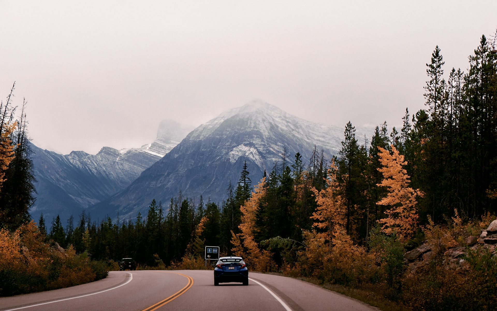
Essential Planning for Driving the Icefields Parkway
Highway 93 runs 232 kilometers through Banff and Jasper National Parks. You’ll need a Parks Canada pass and a little planning to get the most out of the trip.
Maps, Road Tips, and Travel Timing
The Icefields Parkway follows Highway 93 from Lake Louise to Jasper. If you drive straight through, it’s about three hours, but who does that?
I always grab the official Parks Canada map and bring a GPS. Cell service is spotty at best.
Key driving tips:
- Hit the road before 8 AM if you want the viewpoints to yourself
- Fill up your tank before you start—gas stations are rare
- Only pull over at designated spots, not on the highway shoulder
- Use winter tires from October to April
- Pack water, snacks, and warm layers—mountain weather is fickle
The highway’s usually in great shape, but weather can change in a flash. I always check conditions on the Parks Canada site before heading out.
Plan for lots of stops. The best moments happen when you park the car and wander a little.
Park Entry Fees, Passes, and Practical Information
You’ll need a Parks Canada pass for the parkway since it runs through Banff and Jasper. Daily passes are $10.50 CAD per adult, or $21 CAD for a group of up to seven in one vehicle.
Kids under 17? They get in free. I like to buy passes online ahead of time, but you can also grab one at the entrance or a visitor center.
Money-saving options:
- Annual Discovery Pass: $72.25 CAD per adult
- Family/Group Annual Pass: $145.25 CAD
If you’re spending a week or more in the parks, the annual pass pays off fast. Just pop the pass on your dashboard and you’re good to go.
Best Times of Year to Visit
Mid-June through September is prime time. July and August offer the best weather, but you’ll also share the road with the most people.
Seasonal considerations:
Summer (June-August): Warmest weather, everything’s open, lots of travelers
Fall (September-October): Cooler, quieter, but some services start closing
Winter (November-March): Harsh conditions, most attractions closed, only for confident winter drivers
Spring (April-May): Weather’s unpredictable, snow still possible, but fewer crowds
I visited in May once—almost no crowds, but we did get a surprise snowstorm. Always check avalanche forecasts and trail updates before hiking in shoulder season.
The Columbia Icefield Centre opens from mid-April to mid-October. If you’re coming in winter, expect limited access.
Travel Resources and Guided Tours
A few extra resources can really upgrade your Icefields Parkway experience. There’s a smartphone audio tour app for $9 CAD—it’s packed with stories and trivia as you drive.
Rental car options:
- Calgary Airport: All the big names like Avis, Hertz, Enterprise
- Downtown Calgary: Sometimes cheaper than the airport
- Campervans: Escape Campervans and Karma Campervans for those who want to sleep under the stars
If you’d rather not drive, guided tours run from Banff, Lake Louise, and Jasper. They’re great for a day trip, but you won’t have as much freedom to linger.
Winter tire packages are available from most Calgary rental agencies. GPS is a must—the mountains can mess with phone signals.

Major Destinations and Iconic Landmarks Along the Parkway
The Icefields Parkway links Lake Louise and Jasper across 143 miles of pure mountain drama. Four big stops anchor the route: Bow Lake with Crowfoot Glacier, the famous turquoise Peyto Lake, and Saskatchewan River Crossing for a break and some basic services.
Lake Louise to Jasper: Route Overview
The parkway starts at Lake Louise in Banff National Park and ends in Jasper National Park. If you drove straight through, it’d take about three hours, but honestly, that’s missing the point.
The road climbs from Lake Louise through mountain passes and valleys. Bow Summit is the highest spot—6,800 feet up.
Key Route Facts:
- Distance: 143 miles (230 kilometers)
- Drive time: 3+ hours, but plan for more
- Elevation gain: Over 2,000 feet
- Season: Open year-round, but best from May to October
At the Columbia Icefield, you’ll cross from Banff into Jasper. That’s about halfway.
Set aside a full day. The views change so much, you’ll want to stop constantly.
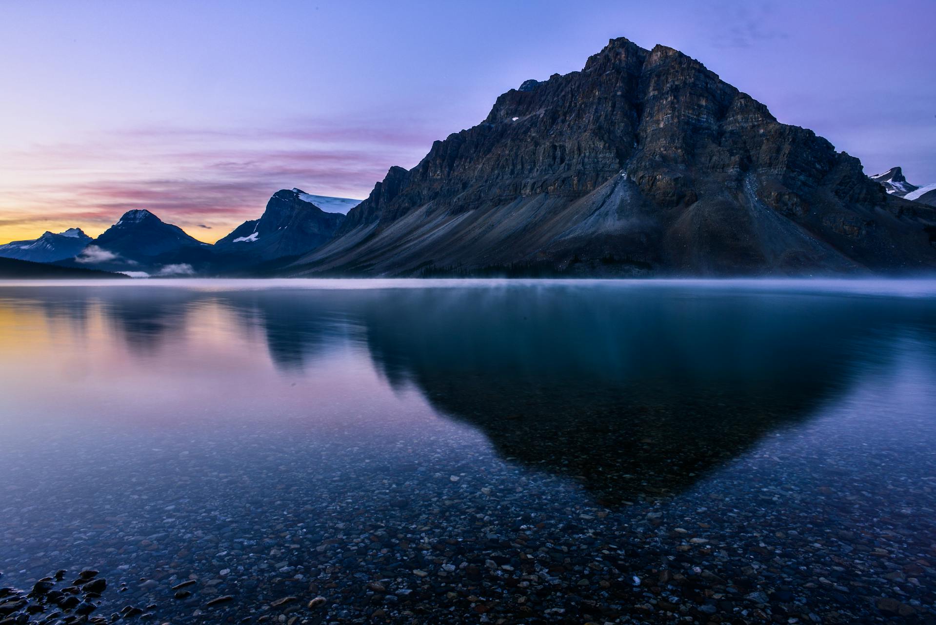
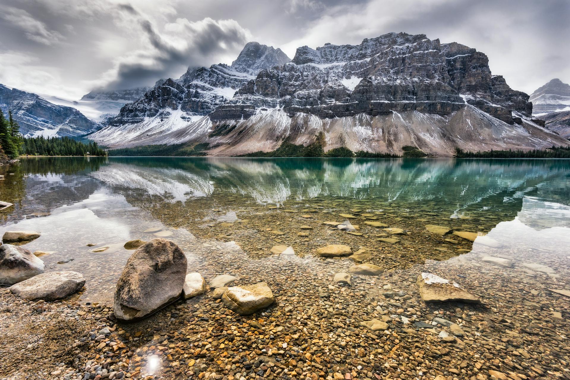
Bow Lake and Crowfoot Glacier
Bow Lake sits right next to the parkway. It feeds the Bow River, which winds all the way down to Calgary and beyond.
Crowfoot Glacier hangs above the lake, perched on the mountainside. It got its name because it used to look like a crow’s foot—three “toes” of ice.
What you’ll see at Bow Lake:
- Crowfoot Glacier on Crowfoot Mountain
- Bow Glacier in the distance
- Mount Thompson looming overhead
- Wapta Icefield stretching across the ridges
On calm days, the lake becomes a mirror for the mountains. There’s a short lakeshore walk if you want a better angle for photos.
A historic lodge sits right at the water’s edge. It’s got that classic alpine vibe and makes a great shelter if the weather turns.
Peyto Lake and Bow Summit
Peyto Lake is probably the most photographed spot in the Rockies. From Bow Summit, a short uphill trail leads to the main viewpoint.
The lake’s unreal turquoise color comes from glacial silt—tiny rock particles suspended in the water.
Peyto Lake Details:
- Viewpoint elevation: 6,800 feet
- Trail length: About half a mile one way
- Best color: June through September
- Peak crowds: July and August
Bow Summit marks the highest point on any public road in Canada. In summer, the parking lot fills up fast.
For the best photos, aim for morning light. The viewpoint faces northeast, so afternoons can cast shadows.
The trail up is paved but steep. In winter, it’s icy and risky, so I stick to summer visits.

Saskatchewan River Crossing and Surroundings
Saskatchewan River Crossing is your only shot at gas and snacks in the middle stretch. Three rivers meet here: the North Saskatchewan, Howse, and Mistaya.
There’s a gas station, a little restaurant, and restrooms—nothing fancy, but it’s a lifesaver after hours on the road. The North Saskatchewan River travels over 1,000 miles east.
Available Services:
- Gas station
- Restaurant
- Public restrooms
- Gift shop
- Tour bookings
If you’re heading to the Columbia Icefield, this is the place to stop, stretch, and refuel.
The views here are all about wide-open valleys and braided rivers. You can see how the water carved its way through the mountains over centuries.
It’s roughly halfway between Lake Louise and Jasper, so it’s a natural place to take a break.
Spectacular Glaciers, Valleys, and Waterfalls
The Icefields Parkway is all about dramatic natural features. Glaciers spill down mountainsides and waterfalls thunder into deep valleys.
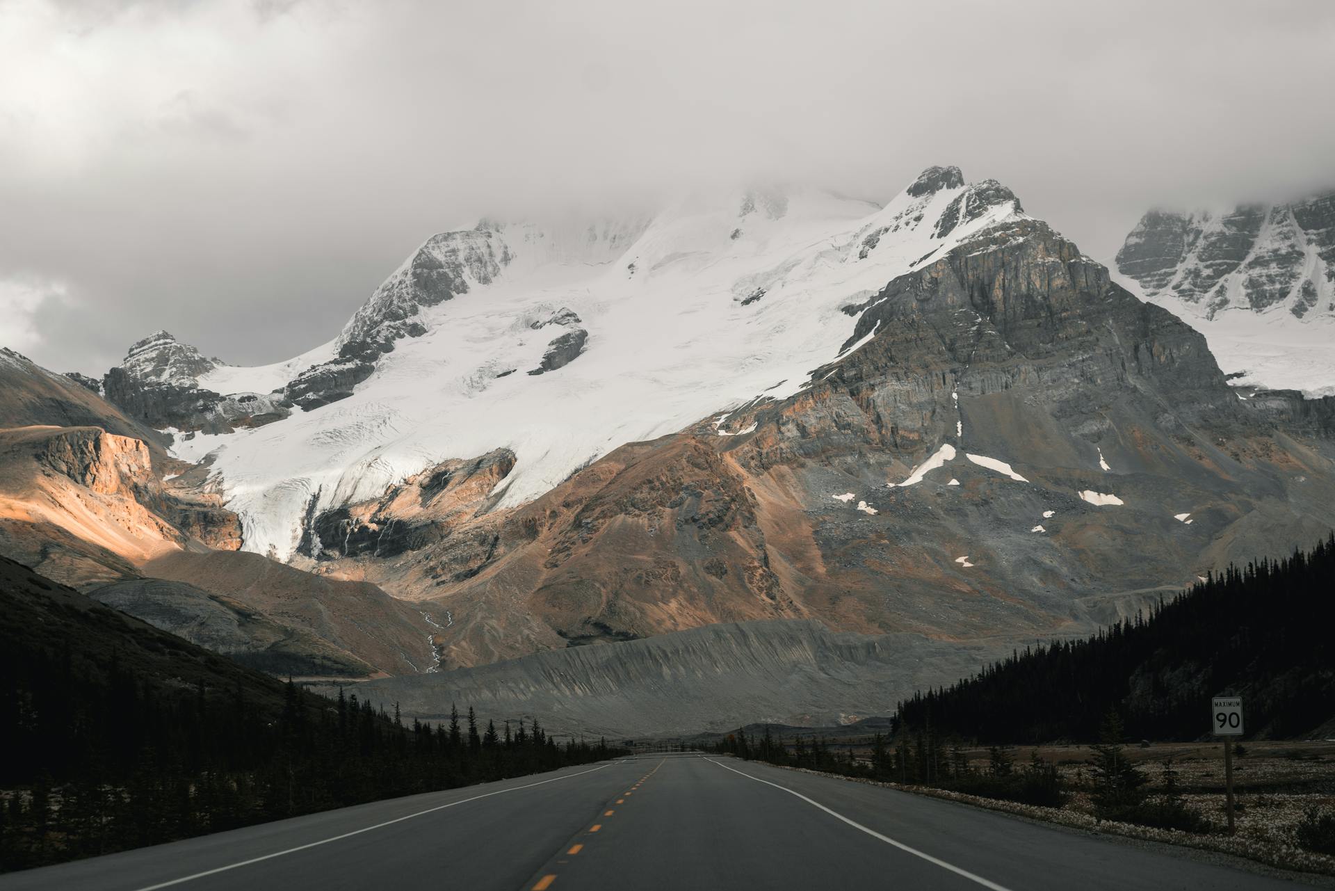
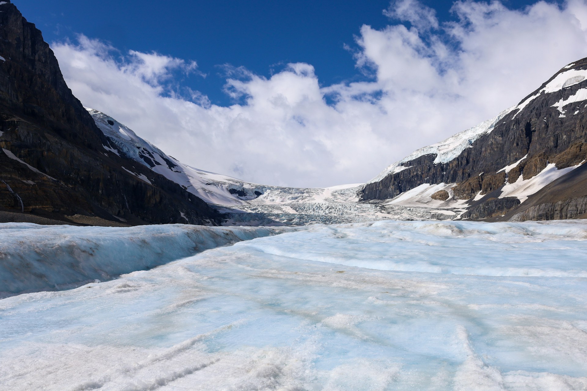
Columbia Icefields and Athabasca Glacier
The Columbia Icefields cover 325 square kilometers. This massive sheet of ancient ice feeds eight major glaciers.
The Athabasca Glacier is the easiest glacier to reach in North America. Just park and walk the short 0.9-mile trail right to the toe of the glacier.
You’ll see markers showing how far the ice has retreated since 1844—over 1.5 kilometers. It’s sobering and impressive at the same time.
Ice Explorer Tours take you right onto the glacier. These massive vehicles handle the slick, steep surface with ease.
The ice here is older than most buildings—over 300 years. You can even taste the meltwater if you bring a bottle.
Key Details:
- Distance from Lake Louise: 130 km
- Trail length: 0.9 miles to the glacier toe
- Tour duration: 3 hours including the Skywalk
- Best time: May through October
Saskatchewan Glacier and Parker Ridge
Saskatchewan Glacier flows from the eastern edge of the Columbia Icefields. The Parker Ridge Trail gives you the best views.
The trail climbs about 305 meters over 2.7 kilometers. It’s well-maintained but has some steep sections.
From the top, you get a sweeping view of the glacier between Mount Athabasca and Mount Andromeda.
What to expect:
- Elevation gain: 305 meters
- Trail difficulty: Moderate
- Round trip time: 2-3 hours
- Views: Saskatchewan Glacier, Castleguard Mountain
The viewpoint sits at 2,135 meters—bring a jacket, it gets chilly.
Early mornings are best for clear views. By afternoon, clouds often roll in and hide the peaks.
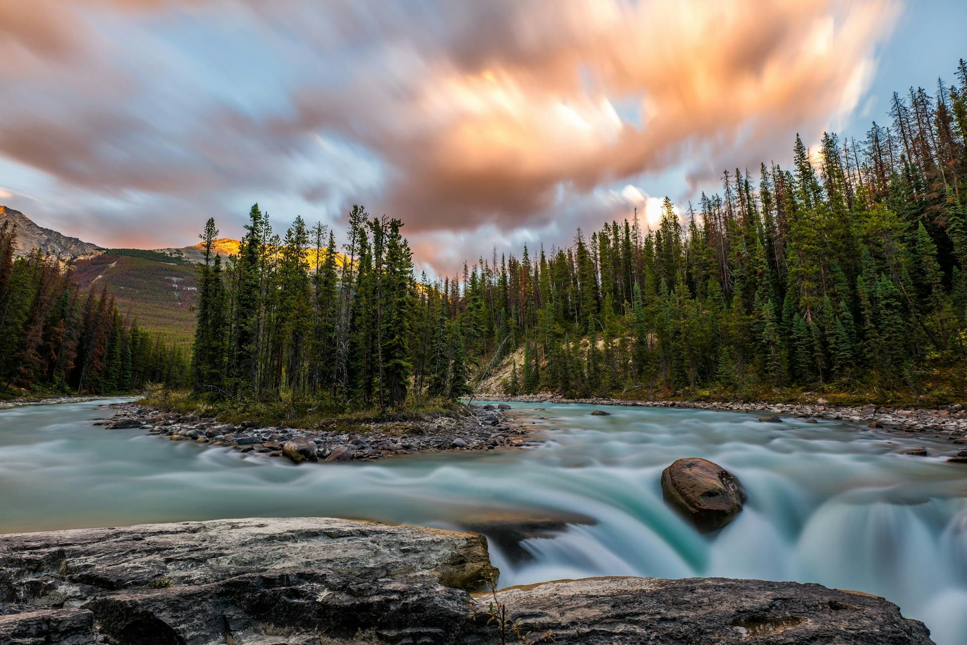
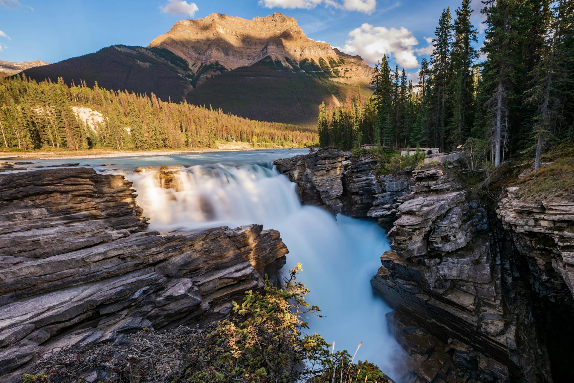
Athabasca Falls and Sunwapta Falls
Athabasca Falls really puts on a show when it comes to raw power. The Athabasca River plunges 23 meters through a tight limestone gorge, and you can hear the thunder before you even see the water.
Over time, the falls have carved out deep potholes in the rock. I love wandering between the different viewpoints—each angle gives you a new perspective on just how wild the water gets.
A paved trail winds its way to several viewing platforms. The main viewpoint sits only 0.3 kilometers from the parking lot, so you don’t have to hike far for that jaw-dropping view.
Sunwapta Falls brings its own magic with two tiers of cascading water. The upper falls are a quick stroll from the parking area, and you can feel the spray on your face if you get close enough.
Trail Information:
- Athabasca Falls: 0.6 miles, 82 feet of elevation gain
- Sunwapta Falls: 2 miles to the lower falls, 469 feet of elevation gain
- Surface: Paved paths to the main viewpoints
- Accessibility: Upper viewpoints are wheelchair accessible
I’ve found both waterfalls at their most powerful in spring, when snowmelt sends torrents of milky blue water over the cliffs. Glacier flour in the water gives it that surreal color—it’s something you have to see in person.
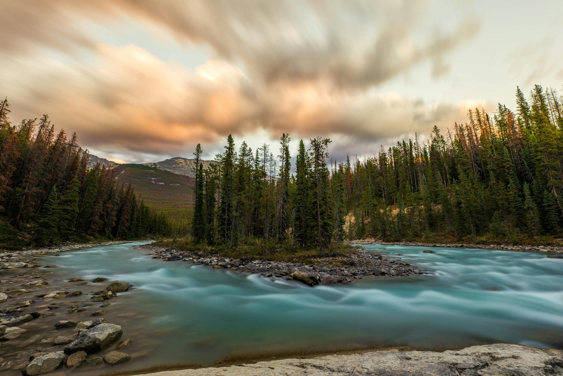
The Sunwapta Valley Experience
The Sunwapta Valley stretches for about 50 kilometers, running between the Columbia Icefields and Jasper. “Sunwapta” means “turbulent water” in the Stoney language, which fits perfectly.
Down on the valley floor, you’re already at 1,800 meters above sea level. Steep mountain walls rise over 1,000 meters on either side, making you feel tiny in the best way.
I always stop at the Goats and Glaciers Lookout for panoramic views. If you’re lucky, you’ll spot mountain goats grazing on the rugged slopes nearby.
The Athabasca River slices right through the center of the valley. Hanging glaciers spill streams down the cliffs, all feeding into the main river.
Valley highlights:
- Length: 50 kilometers
- Width: 2–4 kilometers
- Elevation: 1,800 meters
- Wildlife: Mountain goats, elk, bears
Wildlife uses this valley as a natural corridor, so early morning drives can turn into impromptu safaris. I’ve had elk cross the road right in front of me—always a thrill.
Canadian Rockies National Parks: Protection and Legacy
The Canadian Rocky Mountain Parks make up a UNESCO World Heritage Site that spans seven protected areas across Alberta and British Columbia. These parks keep mountain ecosystems, glaciers, and wildlife habitats safe while inviting travelers to experience the legendary Icefields Parkway.
Banff National Park Wonders
Banff is Canada’s first national park, established way back in 1885. I think its 6,641 square kilometers include some of the most iconic views in all of North America.
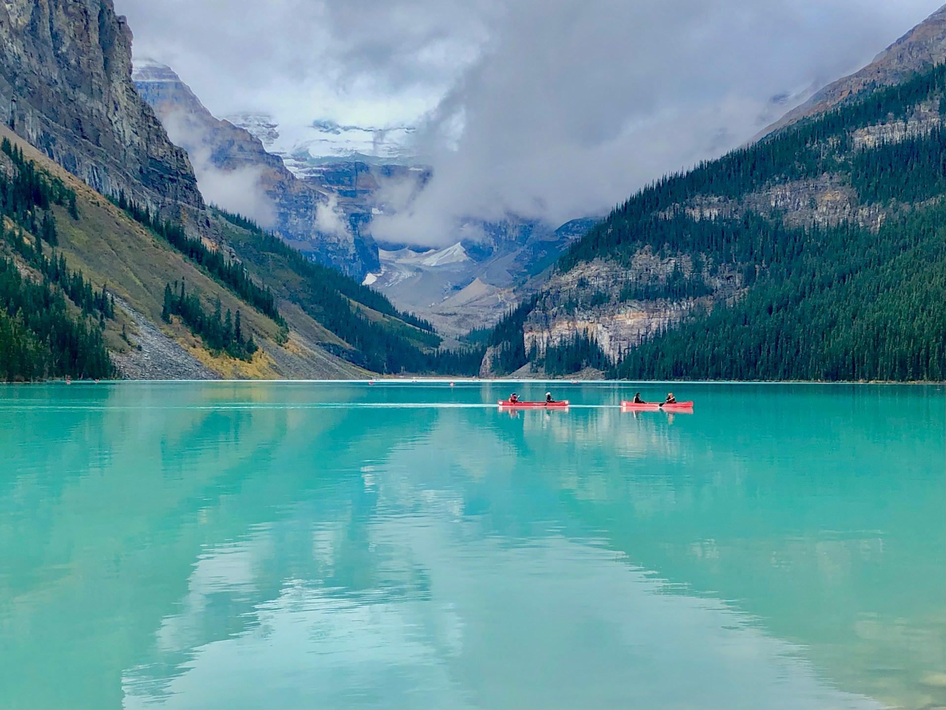
Lake Louise is the star of the show, with turquoise water reflecting snowy peaks year-round. After a 3.5-mile hike, the Plain of Six Glaciers Tea House offers a cozy spot for tea and snacks.
The Bow Valley Parkway winds through prime wildlife territory. Elk, bighorn sheep, and black bears wander here, especially in the early morning if you’re patient.
Johnston Canyon is a favorite for accessible waterfalls and, in winter, magical ice walks. The lower falls are just a 20-minute walk, while the upper falls take about 45 minutes and absolutely reward the effort.
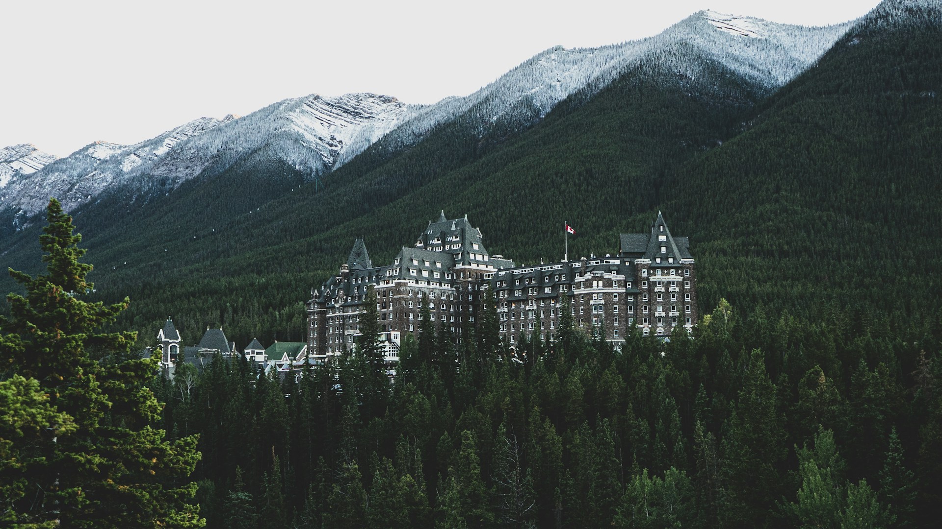
Banff town perches at 1,383 meters. The historic Banff Springs Hotel has been greeting guests since 1888. Hot springs first drew curious travelers to this mountain haven, and they’re still worth a soak.
Jasper National Park Highlights
Jasper covers a whopping 11,228 square kilometers, making it the largest park in the Canadian Rockies. I love how the remoteness preserves its wild, rugged character.
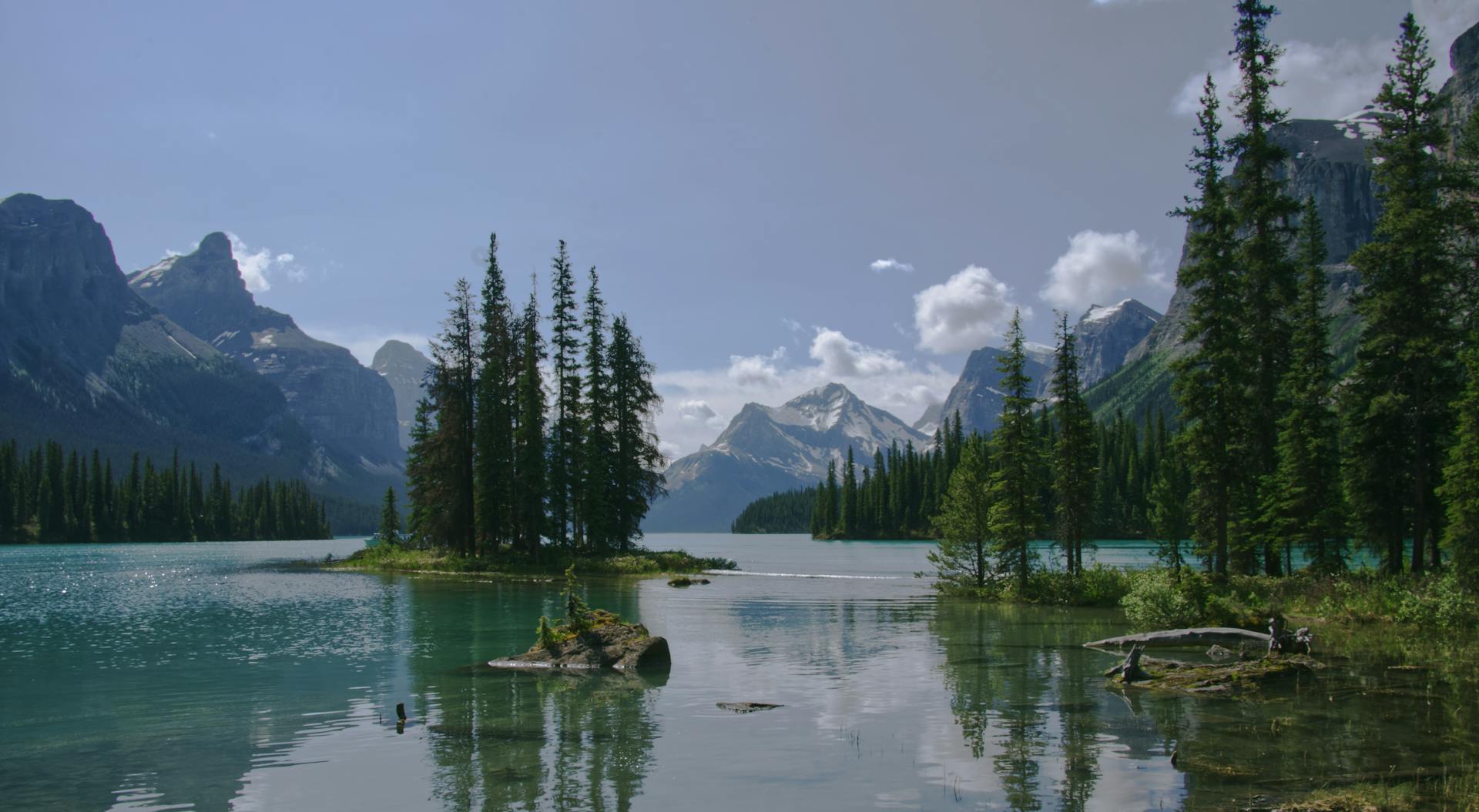
Maligne Lake stretches 22 kilometers and stands as the biggest glacial lake in the region. Spirit Island is probably the most photographed spot—I mean, who could resist? Boat tours run from May through October.
The Columbia Icefield sits on the Continental Divide. You can actually ride an ice explorer vehicle right onto the Athabasca Glacier—talk about a bucket-list experience.
Maligne Canyon slices 50 meters deep through limestone. Five bridges cross the gorge, and in winter, the frozen waterfalls and icy formations make it feel like a different planet.
Mount Edith Cavell towers at 3,363 meters. The Angel Glacier clings to its north face, and a scenic drive takes you right up to the base parking area.
Yoho National Park: Adjacent Treasures
Yoho National Park protects 1,313 square kilometers on the British Columbia side. “Yoho” means “awe and wonder” in Cree—and honestly, it fits.
Takakkaw Falls plunges 373 meters from the Daly Glacier. I’d rank it among Canada’s tallest and most dramatic waterfalls. The access road opens from June to October, so plan your trip accordingly.
The Burgess Shale hides 505-million-year-old fossils. Guided hikes take you to these ancient marine life sites—definitely a must for geology buffs.
Emerald Lake glows a vivid green thanks to glacial sediment. There’s a 5.2-kilometer loop trail around the shore, and the historic Emerald Lake Lodge stays open all year.
The Natural Bridge shows how water can carve through solid rock. The Kicking Horse River did all the work over thousands of years, and it’s mesmerizing to see up close.

Contribution of Parks Canada
Parks Canada manages four national parks in this World Heritage area. Since 1911, they’ve balanced conservation with letting people experience these wild places.
Wildlife corridors link habitats across park boundaries, helping animals migrate safely. Overpasses and underpasses prevent a lot of wildlife-vehicle collisions.
Research programs keep an eye on how glaciers and ecosystems are changing. Scientists track glacier retreat and animal populations, and their findings help shape park management.
Indigenous partnerships are vital here. The Stoney Nakoda, Blackfoot, and other nations continue to honor their deep connections to these lands.
More than 2,000 people work for Parks Canada in the mountain parks. Rangers, interpreters, and maintenance crews keep visitors safe and the parks thriving.

Wildlife Encounters, Epic Photography, and Where to Stay
The Icefields Parkway is a dream for wildlife lovers and photographers alike. But heads up—accommodations fill up fast in summer, so book early if you want to stay close to the action.
Wildlife Viewing Tips and Safety
Wildlife roams freely along all 232 kilometers of the parkway. I’ve spotted black bears, grizzlies, elk, mountain goats, and bighorn sheep—all from the comfort of my car.
Dawn and dusk are prime times for sightings. Animals like to feed near the road when it’s cooler, so keep your camera ready.
- Stay inside your vehicle when you see wildlife
- Give bears and wolves at least 100 meters of space
- Keep 30 meters away from elk and deer
- Never feed wild animals
Pull all the way off the road if you stop. Other drivers get distracted, too. I always bring bear spray when hiking, no matter how short the trail.
Mountain goats love the Parker Ridge area, and bighorn sheep hang out near Bow Lake. Park rangers often have the latest wildlife updates, so don’t hesitate to ask.

Top Photo Stops and Hidden Gems
Every few kilometers, the parkway throws another epic photo op your way. Peyto Lake is the classic—it’s shaped like a wolf’s head and the turquoise water is unreal.
Must-Photograph Locations:
- Bow Lake – glacier reflections that are almost too perfect
- Athabasca Falls – thunderous cascades and dramatic spray
- Mount Christie – stunning views right from the Athabasca Falls parking lot
- Sunwapta Falls – the multi-tiered waterfall system
Hidden gems? I’d say the Weeping Wall during spring melt—dozens of temporary waterfalls pour down the cliffs, and it’s easy to miss if you’re not looking.
The Glacier Skywalk lets you step out on a glass platform over the valley. Go early for the best light and fewer crowds.
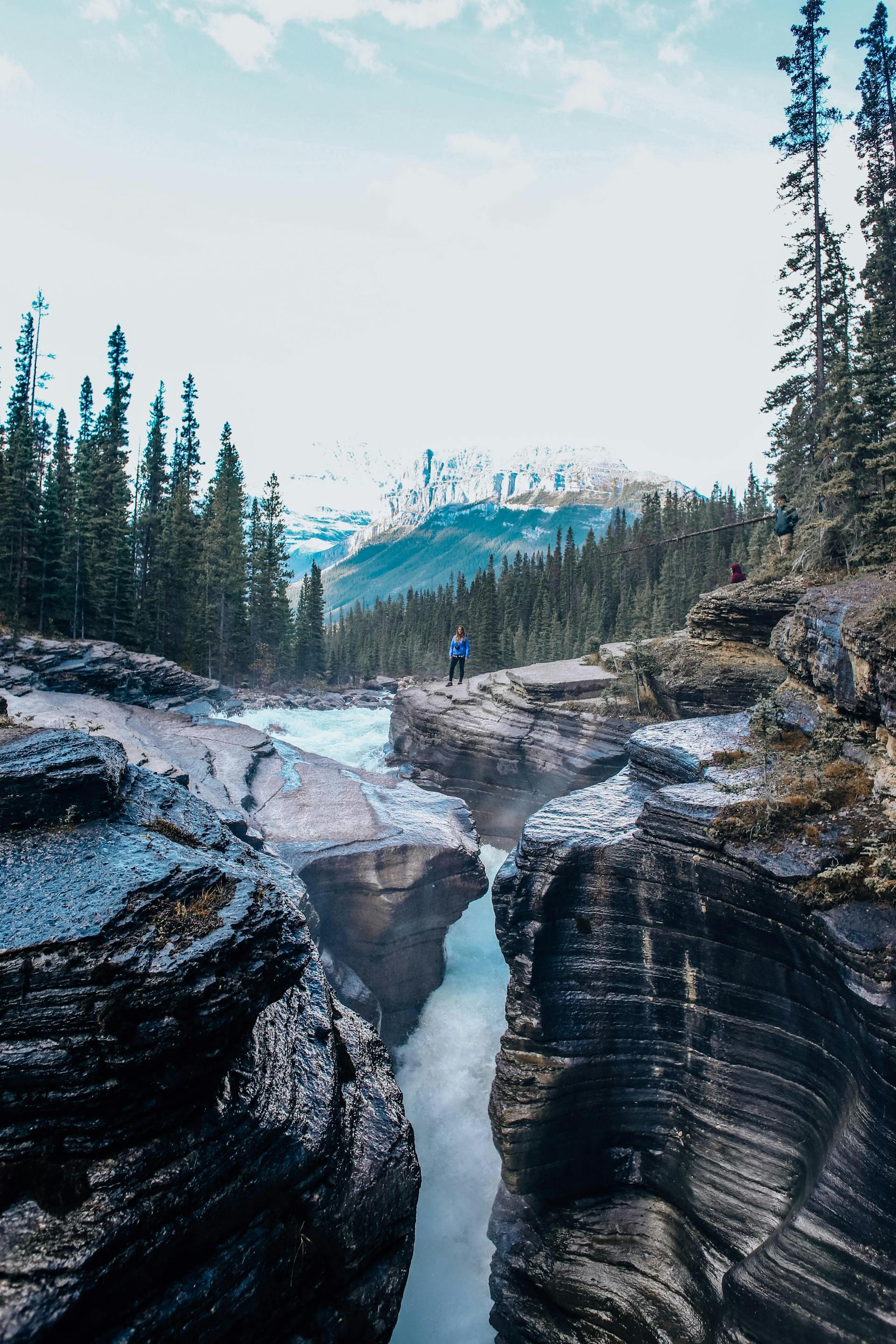
Mistaya Canyon is a quick 10-minute walk but reveals some of the wildest rock formations around. Most people drive right past, but it’s absolutely worth the stop.
Recommended Lodges and Accommodations
So, there are only three main hotels right on the parkway. If you want to visit in summer, definitely book months in advance—trust me, spots go fast.
The Crossing Resort sits smack in the middle between Lake Louise and Jasper. Depending on the season, you’ll pay anywhere from $159 to $379 CAD per night. The best part? You’re just 30 minutes from some of the biggest sights.
Looking for something fancy? Glacier View Lodge gives you luxury rooms with a front-row seat to the Columbia Icefield. Prices start at $220 CAD but can hit $400 CAD during peak times. I always suggest this spot if you’re planning an Athabasca Glacier tour—it’s right at your doorstep.
Sunwapta Falls Lodge opens only from May to October. It’s about 40 minutes south of Jasper, and rooms usually start around $220 CAD per night. The setting feels a bit tucked away, which I love after a busy day exploring.
If you’re on a budget, check out HI Athabasca Falls hostel near Jasper. Shared dorms go for just $27 CAD per person. It’s pretty basic—no showers or flush toilets—but it covers all the essentials for a night or two.
Don’t forget, you’ll need a Parks Canada pass for all these places. It’s $21 CAD per vehicle each day, or $145.25 CAD if you want to grab an annual pass.