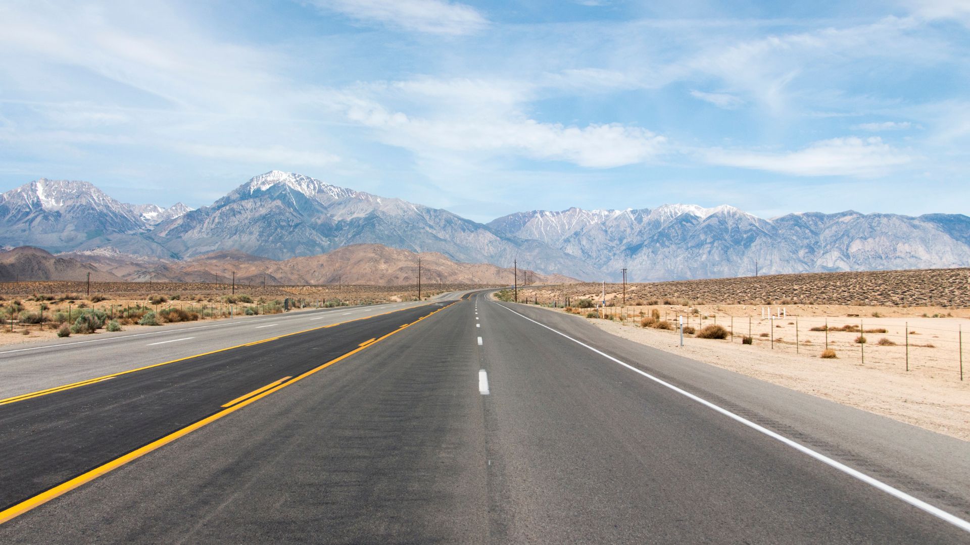
Every fall, Highway 395 in California puts on a show. The Eastern Sierra corridor—about 150 miles from Lone Pine to Bridgeport—turns into a wild parade of golden aspens, cottonwoods, and willows, all set against those rugged Sierra Nevada peaks.
If you love autumn, this drive is honestly one of the best in the American West. I’ve chased the colors here for years, and every season feels a little different. Sometimes the aspens pop early, other times the cottonwoods hang on longer. Elevation and weather keep you guessing!
The best time to catch the fall color in the Eastern Sierra usually lands between late September and mid-October. The timing shifts depending on where you are—higher spots like North Lake or Lake Sabrina go off first, while the lower valleys can hold their gold into October.
Let me walk you through what I’ve learned—how to time your trip, where to stop, and which hidden gems along Highway 395 shouldn’t be missed. I’ll also share some favorite side adventures and practical tips to help you make the most of your autumn road trip.
Essential Fall Color Facts for the Eastern Sierra
Fall in the Eastern Sierra depends on timing, tree types, and how the mountains shape the season. The region’s unique mix of weather and elevation means every bend in the road can surprise you.
Peak Leaf Peeping Periods
The fall color season here runs from mid-September to mid-October, but honestly, it’s all about elevation.
Early Season (Mid-September):
- 8,000-10,000 feet up—think Mammoth Lakes, June Lake, and backcountry aspen groves
Peak Season (Late September to Early October):
- 6,000-8,000 feet, covering most of the Highway 395 corridor
- Bishop Creek Canyon and Rock Creek shine right about now
Late Season (Mid-October):
- Below 6,000 feet—Owens Valley and the cottonwoods in Inyo County
If you’re aiming for the sweet spot, the first week of October usually delivers color across several elevations.
Types of Trees and Hues
Three main trees steal the show here, each with its own flair.
Quaking Aspens are the stars—those bright golden leaves you see in all the photos? That’s them. Big groves at elevations above 7,000 feet turn entire hillsides gold.
Cottonwoods line the creeks and rivers, especially in Mono County and Owens Valley. They show up later, but their deep gold can be just as striking.
Willows add pops of orange and red. They’re smaller and easy to overlook, but they round out the color palette.
You won’t find the blazing red maples of the Northeast, but honestly, the warm yellows, golds, and oranges here feel magical in their own way.

Weather and Elevation Impacts
If you want to time your trip right, pay attention to temperature and elevation. I’ve learned the hard way that a cold snap can change everything overnight.
Temperature Triggers:
- Cool nights (below 45°F) kick off the color change
- Warm days keep leaves hanging on
- Early frost? That’ll cut the show short
Elevation Effects:
- Color starts high and moves lower each week
- Every 1,000 feet in elevation is about 1-2 weeks’ difference
- Lower areas like Inyo County peak after the high country
Weather Patterns:
- Dry spells make colors pop
- Wind storms can strip the leaves fast
- An early snowstorm? Game over
The Sierra’s wild elevation swings mean you can chase color up or down the mountains for weeks. It’s part of the fun—and the challenge.
Mapping the Ultimate Highway 395 Autumn Road Trip
If you want to catch the best of Highway 395 in autumn, start with a good plan. I usually recommend beginning in either Los Angeles or Topaz, and giving yourself at least 3-5 days.
Best Starting Points: Los Angeles and Topaz
Los Angeles is the obvious pick if you’re coming from SoCal. It’s about five hours to Mammoth Lakes on US 395.
Leave before sunrise if you can. There’s nothing like rolling into the Eastern Sierra with the afternoon light hitting those aspens.
Topaz is my go-to if I’m coming from the north. It’s right on the California-Nevada border and puts you close to the first bursts of color.
From Topaz, you can head south and hit June Lake and Mammoth Lakes before the crowds.
Both routes work—pick based on where you live and whether you want to drive north or south through the Sierra.
Recommended Route Planning
I always map my route by elevation. Higher spots like June Lake and Mammoth Lakes light up first, usually late September.
Key stops from north to south:
- June Lake Loop (7,600 feet)
- Mammoth Lakes (7,800 feet)
- Convict Lake (7,600 feet)
- Rock Creek Canyon (7,000 feet)
Start high, then work your way down. That way, you have the best shot at catching peak color.
Give yourself extra time at June Lake Loop. I never rush it—it’s worth a half-day, at least.
Don’t forget to plan your gas stops. There’s a long stretch between Mammoth Lakes and Bishop with not much in between.
Suggested Trip Length and Itineraries
3-Day Trip:
- Day 1: June Lake Loop and Mono Lake
- Day 2: Mammoth Lakes and Convict Lake
- Day 3: Rock Creek Canyon and McGee Creek
5-Day Trip:
- Add Bodie State Park and more hiking
- Stay overnight in different towns
- Flex your schedule for weather or spontaneous photo stops
If it’s your first time, go for five days. The extra time lets you soak it all in without feeling rushed.
Weekend trips are possible, but you’ll spend more time in the car than actually exploring.
Book your hotels or campsites early—late September and early October are busy.
Most Spectacular Fall Color Destinations Along Highway 395
From late September to mid-October, the Eastern Sierra explodes with color. Some spots just hit differently—here are my absolute favorites for unforgettable autumn views.
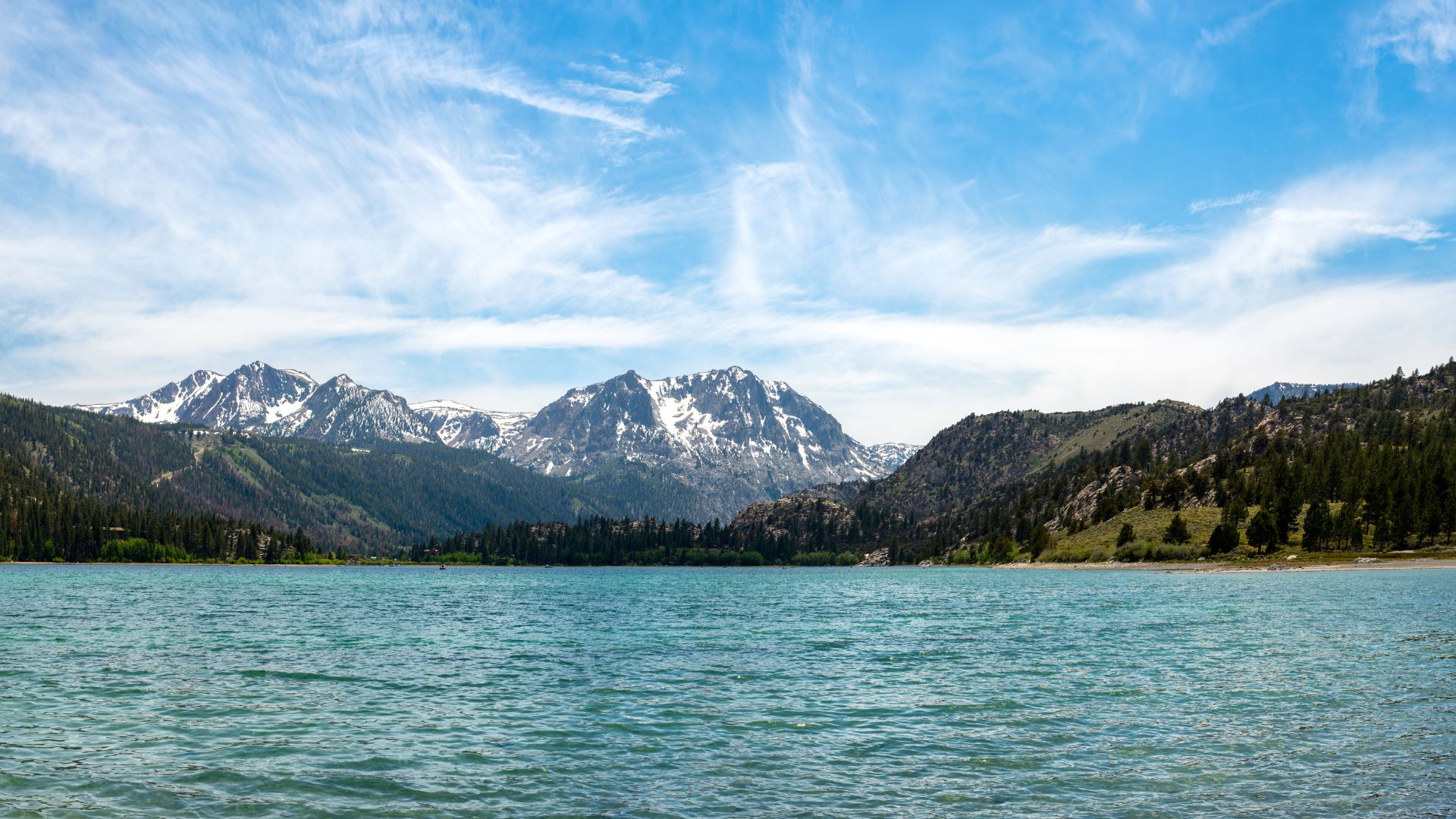
June Lake Loop: Grant Lake, Silver Lake, & June Lake
The June Lake Loop (Highway 158) is a 16-mile circle around four alpine lakes. Each one has its own autumn magic, and I always start here.
Grant Lake anchors the north end. By early October, the hills above it glow gold. I love the view from the dam—look southwest to catch the best aspen groves.
Silver Lake is a photographer’s dream. Mornings are quiet, the water’s still, and the aspens reflect perfectly. The Silver Lake Resort area makes it easy to park and wander.
June Lake sits at the south end. The turquoise water with golden aspens? It’s almost too pretty. Head to the June Lake Marina for the best photo ops.
Colors usually peak in the first two weeks of October. If you’re up for it, catch sunrise for the calmest water and golden light.

Mono Lake and South Tufa Towers
Mono Lake’s weird beauty always surprises me. The South Tufa Area pairs surreal limestone towers with golden willows along the shore.
Those tufa towers rise up like something from another planet. In autumn, willows and aspens frame the scene in gold. The blue-green lake against all that color—there’s really nothing else like it in California.
Lee Vining is your gateway here, right off Highway 395. The South Tufa parking area is easy to find and leads you straight to the best views.
With an elevation around 6,400 feet, colors here usually peak in early October. The alkaline waters support plants that turn wild shades of yellow and orange.

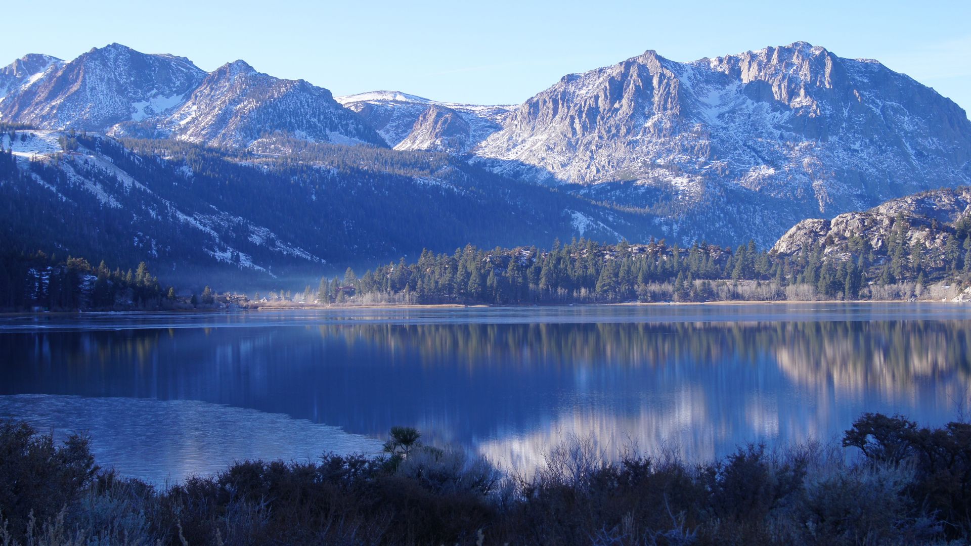
Mammoth Lakes and Environs
Mammoth Lakes packs a ton of fall color into a small area. Twin Lakes is just three miles from town and is super easy to reach.
The Tamarack Lodge area around Twin Lakes is a favorite—golden aspens, calm water, and those Sierra peaks. Lake Mary and Lake Mamie offer different angles and more color.
Mammoth Creek runs right through town, lined with aspens and willows. The Welcome Center is a good spot for a quick walk through the leaves.
Convict Lake sits south of town, dramatic as ever. The golden aspens against granite cliffs are unreal, and the deep blue water makes the colors pop.
These lakes usually peak between late September and early October, thanks to their higher elevation.

Bishop and Big Pine Highlights
Bishop’s area might be the most diverse for fall colors. North Lake is classic Sierra—golden aspens set against granite peaks.
Lake Sabrina and South Lake form a triangle with North Lake, each offering a different take on autumn scenery near the John Muir Wilderness.
Big Pine Creek marks the southern edge of reliable color. The canyon holds secret aspen groves that turn gold in early October.
The Owens River near Bishop is lined with cottonwoods and willows, creating yellow ribbons through the valley. These spots peak a bit later than the lakes.
Aspendell is a tiny village tucked in one of the largest aspen groves around. The Cardinal Village Resort area is a great spot to wander and take in the colors.
Must-See Natural Wonders Beyond the Aspens
The Eastern Sierra isn’t just about fall leaves. The region’s geology and ancient forests add a whole extra layer to your adventure. Seriously, these spots will blow your mind.
Alabama Hills and Mobius Arch
You can’t skip the Alabama Hills if you’re anywhere near Lone Pine. Rounded granite boulders sprawl across the landscape, with the sharp Sierra peaks looming behind.
The main draw? Mobius Arch. It perfectly frames Mount Whitney—the tallest peak in the lower 48 at 14,505 feet.
The short hike to Mobius Arch is about 0.6 miles and takes maybe 20 minutes each way. I always try to visit during golden hour. The light on the arch and Whitney is unbeatable.
Key Details:
- Distance from Lone Pine: 3 miles west
- Hiking difficulty: Easy
- Best viewing time: Early morning or late afternoon
Ancient Bristlecone Pine Forest: Schulman & Patriarch Groves
The Ancient Bristlecone Pine Forest is home to some of the oldest living things on earth. Seriously—these trees have been around for over 4,000 years.
Schulman Grove sits at 10,000 feet and has two main trails. The Discovery Trail is a mellow 1-mile loop, perfect for a quick intro. The Methuselah Trail is 4.3 miles and passes the legendary Methuselah Tree.
Patriarch Grove is even higher, at 11,000 feet, and features the massive Patriarch Tree—36 feet around and the largest bristlecone pine known.
Visiting Information:
- Season: May through October
- Elevation gain: 800-1,000 feet
- Drive time from Big Pine: About an hour on winding mountain roads
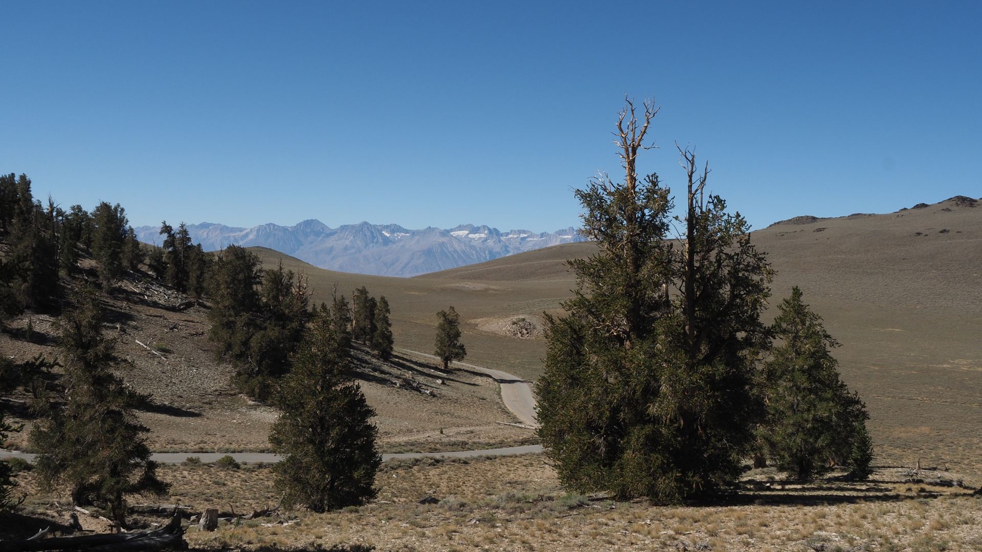
White Mountains and Methuselah Trail
The White Mountains shoot up just east of the Sierra Nevada, pushing past 14,000 feet. Up here, ancient bristlecone pines cling to the rocky slopes, thriving in conditions that would challenge just about anything else.
The Methuselah Trail snakes through Schulman Grove, taking hikers right past trees that started growing before the pyramids even existed. This 4.3-mile loop climbs about 800 feet, so it’s not exactly a stroll, but it’s absolutely worth the effort.
If you’re heading up, pack some warm layers. The temperature drops fast at 10,000 feet, and the thin air can sneak up on you, making the hike feel tougher than it looks.
The visitor center does a great job showcasing these ancient trees and explaining how they survive such extremes.
Scenic Side Trips and Historic Stops
Highway 395 isn’t just about fall colors—there’s a whole world of film history, desert vistas, and old mining towns tucked just off the main road. Honestly, these detours add so much character and variety to any Eastern Sierra trip.
Red Rock Canyon State Park and Mojave Desert
Red Rock Canyon State Park sits about 100 miles south of Lone Pine, so it’s a logical stop if you’re driving the whole Highway 395 stretch. The park’s red cliffs and wild rock shapes make it feel a bit like another planet.
Best Photo Spots:
- Hagen Canyon Nature Trail – An easy mile-long walk weaving through those iconic red rocks.
- Red Cliffs Natural Preserve – Massive sandstone walls, just begging for a photo.
- Scenic Drive – A quick 2.5-mile loop through the park’s most dramatic scenery.
The Mojave Desert around the park changes in fall—cooler temps, golden light, and fewer crowds. If you can, swing by in late afternoon when the rocks practically glow under the setting sun.
Red Rock connects with historic Route 66, so you get a bit of Americana with your desert adventure. If you’ve got time, pairing this stop with the Mojave National Preserve makes for a full day of desert exploring.

Lone Pine’s Movie History: Museum of Western Film History
Lone Pine has been Hollywood’s go-to backdrop for more than 400 films and TV shows since the 1920s. The Museum of Western Film History pulls you right into that legacy, with displays and memorabilia that make you feel like you’ve stepped onto a set.
Museum Highlights:
- Film location maps that pinpoint where the big scenes were shot.
- Props and costumes from classic westerns.
- Interactive displays about the stars who filmed here.
Right outside, the Alabama Hills stretch out—those rounded boulders and jagged peaks look familiar for a reason. I love driving the Alabama Hills Scenic Route after the museum to spot actual filming locations.
Popular filming spots include:
- Mobius Arch (it’s in more westerns than I can count)
- Movie Flat Road (classic chase scenes galore)
- Whitney Portal Road (that epic mountain backdrop)
Fall brings perfect weather for exploring outdoors. The light at golden hour? It’s pure movie magic—those rocks just light up.
California Gold Rush Heritage Drives
The Eastern Sierra played a huge role during California’s gold rush. You’ll find old mining towns and historic sites just a short drive off Highway 395.
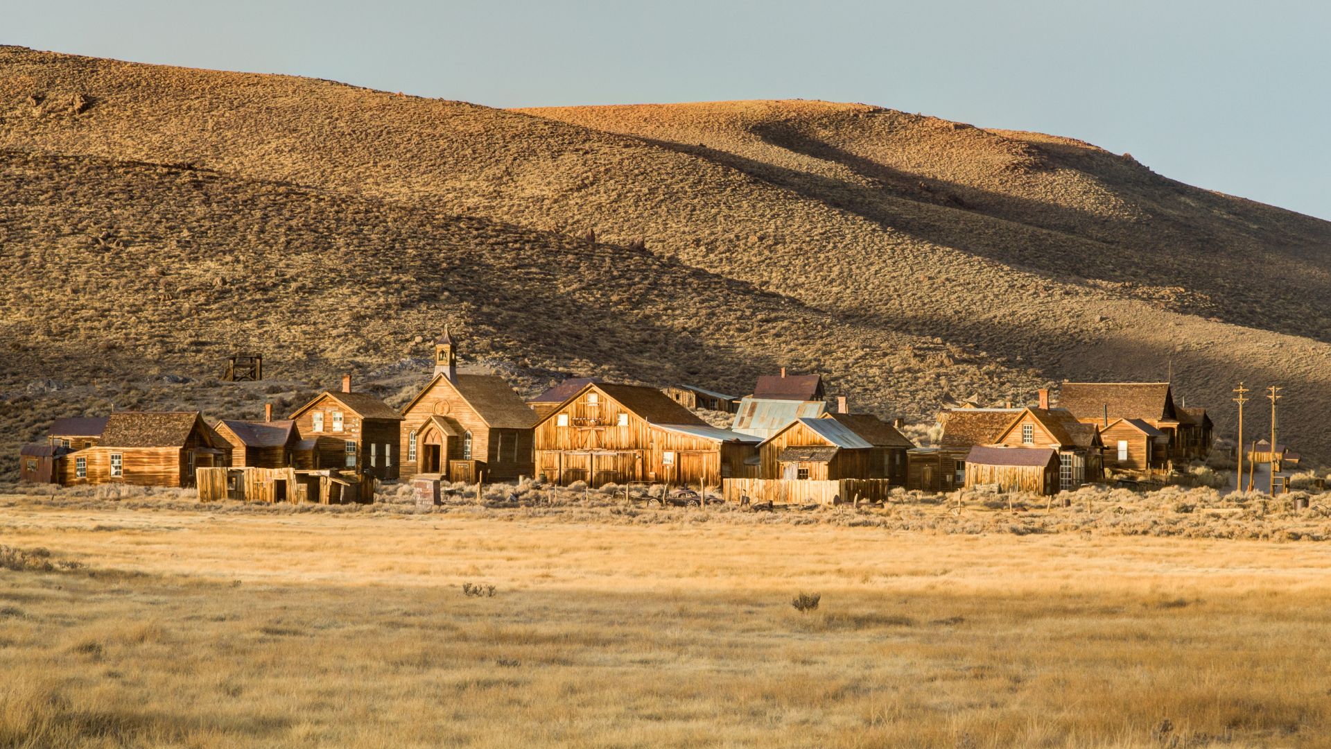
Bodie State Historic Park sits 13 miles east of Bridgeport on Highway 270. This ghost town feels frozen in time, with over 100 buildings from the wild 1880s. It’s open all year, but winter trips can get tricky; chains are often required.
Cerro Gordo near Lone Pine still gives tours of its old silver mining town. Back in its heyday, the place churned out more than $13 million in silver.
Darwin is another mining camp that’s held onto its gritty charm. You’ll need a high-clearance vehicle to get there from Lone Pine, but the mining ruins and desert views make the trek worth it.
These drives pair perfectly with the fall foliage. October’s cooler weather makes wandering ghost towns way more pleasant, and those golden aspens in the canyons are just icing on the cake.
Exploring Whitney Portal Road and Mount Whitney
Whitney Portal Road winds 13 miles west from Lone Pine, climbing 4,000 feet straight up to the Mount Whitney trailhead. The landscape changes fast—one minute you’re in high desert, the next you’re surrounded by pines and granite.
Road Highlights:
- Lone Pine Creek – Brilliant fall colors from cottonwoods and willows.
- Whitney Portal Store – A classic stop for snacks and supplies.
- Trailhead views – Those jagged peaks and alpine scenery never get old.
Mount Whitney towers at 14,505 feet, the highest spot in the lower 48. You don’t have to hike to the top to soak in the views—just hanging out at the portal feels special.
Fall is honestly the best time for this drive. Aspens go gold up high, and the desert below shifts into warm autumn tones. The road usually stays open through October, but check ahead if storms are in the forecast.
Photography tips:
- Catch the morning light on Mount Whitney’s eastern face.
- Afternoon shadows add drama to the Alabama Hills.
- Golden hour ties it all together—desert and mountains in one shot.
Travel Essentials and Local Favorites
If you’re planning a fall color trip along the Eastern Sierra, book your place to stay early. October weekends fill up fast, especially during peak foliage.
Lodging and Campgrounds
Bishop has the widest range of places to stay on Highway 395. I like the old-school motels downtown, but you’ll also find newer hotels near the airport.
For camping, Sabrina Campground and Intake 2 Campground in Bishop Creek Canyon are my favorites. They’re right in the heart of aspen country, but spots go quick during peak season.
Mammoth Lakes is the spot for resort-style digs. It’s about 45 minutes north of Bishop if you’re after more amenities.
Booking Tips:
- Reserve campsites up to 5 months ahead on Recreation.gov.
- Hotels start filling by August for those busy October weekends.
- If you can, stay Sunday through Thursday for better rates and fewer crowds.
Dining Highlights: Erick Schat’s Bakkery
Erick Schat’s Bakkery in Bishop is a must every time I’m in the Eastern Sierra. This Dutch bakery has been a staple since 1938, and it’s easy to see why.
Their sheepherder bread is famous—thick, crusty, and perfect for sandwiches or just tearing off a hunk on the trail. I rarely leave without a loaf (or two) and a sandwich for the road.
Must-try items:
- Original sheepherder bread
- Cinnamon rolls (grab one warm if you’re there early)
- Deli sandwiches stacked on fresh bread
- Dutch apple turnovers
They open at 6 AM, so it’s easy to swing by for breakfast before heading out to chase that morning light on the aspens.
Photo and Safety Tips
When I’m chasing fall colors, I always bring a polarizing filter. It really helps cut the glare on lakes and makes those reds and yellows pop. Cold mountain air seems to eat batteries for breakfast, so I throw a few extras in my bag.
Layers are a lifesaver out here. Mornings can hit 30°F, and then by afternoon, you’re peeling down to a t-shirt at 70°F. The weather never really sits still in the mountains.
If you’re hoping for that perfect shot, aim for golden hour—about half an hour after sunrise feels magical. I’ve found the best light usually falls between 7-9 AM or late afternoon, around 4-6 PM. Midday? The shadows get pretty harsh, so I usually take a break then.
It’s smart to let someone know where you’re hiking, even if you’re just wandering to a nearby aspen grove. And don’t forget water—trust me, even short walks can sneak up on you.